
Tropical system east of Philippines forecast to become Noul and approach Taiwan this weekend
A tropical disturbance east of the Philippines is forecast to strengthen into Tropical Storm Noul and track near Taiwan this weekend, prompting potential sea warnings, while separate tropical storm warnings remain in effect for coastal waters of Alabama, Louisiana and Florida.
Taiwan braces for approaching tropical storm
A tropical system east of the Philippines could strengthen into a tropical storm as early as today, which could affect Taiwan’s coastal waters by the weekend, the Central Weather Administration (CWA) said yesterday. [1] CWA forecaster Cheng Chieh-jen said that the tropical disturbance east of the Philippines had previously been forecast to cross the Philippines before entering the South China Sea. [1] However, the latest forecasts from various countries indicate a more northerly track, making passage through the Bashi Channel the most likely scenario and potentially increasing its impact on Taiwan, he said. [1] As of noon yesterday, the system was 1,600km east-southeast of Taiwan’s southernmost tip at Oluanpi, moving west-northwest at 20kph, Cheng said. [1] The northward shift means the system is less likely to be disrupted by land and would move over warmer ocean waters, conditions that are favorable for further intensification, Cheng said. [1] It was expected to strengthen into a tropical depression as early as yesterday and could become Tropical Storm Noul, the 12th named storm of this year’s Pacific typhoon season, sometime between today and tomorrow, Cheng said. [1] The developing storm is forecast to make its closest approach to Taiwan tomorrow and on Saturday, he added. [1]
Forecast track shifts northward
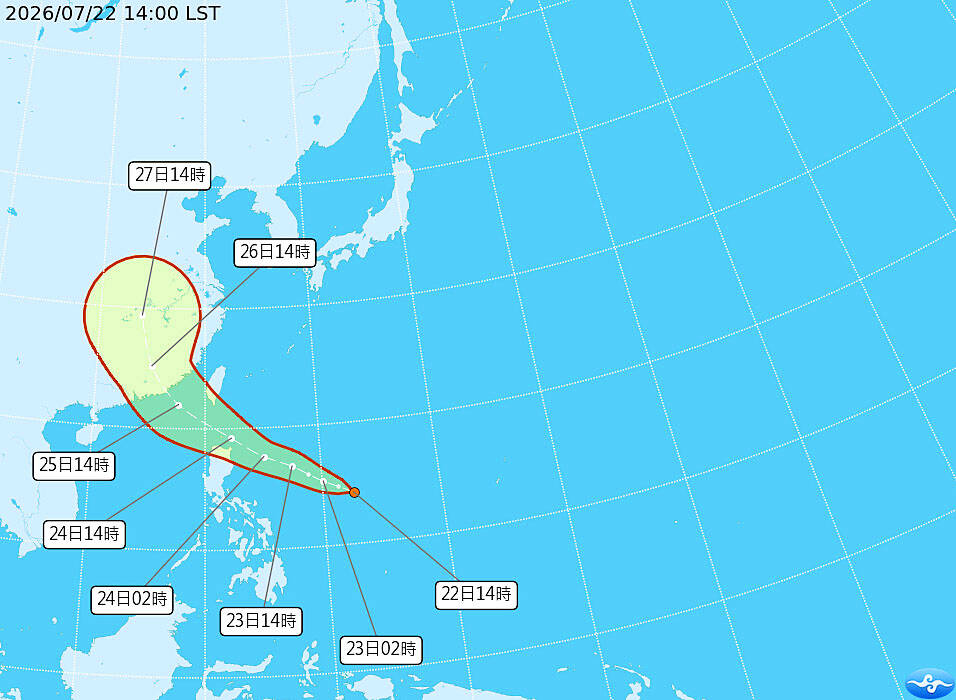
A tropical system east of the Philippines could strengthen into a tropical storm as early as today, which could affect Taiwan’s coastal waters by the weekend, the Central Weather Administration (CWA) said yesterday. [1] CWA forecaster Cheng Chieh-jen said that the tropical disturbance east of the Philippines had previously been forecast to cross the Philippines before entering the South China Sea. [1] However, the latest forecasts from various countries indicate a more northerly track, making passage through the Bashi Channel the most likely scenario and potentially increasing its impact on Taiwan, he said. [1] As of noon yesterday, the system was 1,600km east-southeast of Taiwan’s southernmost tip at Oluanpi, moving west-northwest at 20kph, Cheng said. [1] The northward shift means the system is less likely to be disrupted by land and would move over warmer ocean waters, conditions that are favorable for further intensification, Cheng said. [1] It was expected to strengthen into a tropical depression as early as yesterday and could become Tropical Storm Noul, the 12th named storm of this year’s Pacific typhoon season, sometime between today and tomorrow, Cheng said. [1] The developing storm is forecast to make its closest approach to Taiwan tomorrow and on Saturday, he added. [1] A map shows the projected path of Tropical Storm Noul as of 2pm yesterday. [1]
Potential sea warning and rainfall impacts
A tropical system east of the Philippines could strengthen into a tropical storm as early as today, which could affect Taiwan’s coastal waters by the weekend, the Central Weather Administration (CWA) said yesterday. [1] CWA forecaster Cheng Chieh-jen said that the tropical disturbance east of the Philippines had previously been forecast to cross the Philippines before entering the South China Sea. [1] However, the latest forecasts from various countries indicate a more northerly track, making passage through the Bashi Channel the most likely scenario and potentially increasing its impact on Taiwan, he said. [1] As of noon yesterday, the system was 1,600km east-southeast of Taiwan’s southernmost tip at Oluanpi, moving west-northwest at 20kph, Cheng said. [1] The northward shift means the system is less likely to be disrupted by land and would move over warmer ocean waters, conditions that are favorable for further intensification, Cheng said. [1] It was expected to strengthen into a tropical depression as early as yesterday and could become Tropical Storm Noul, the 12th named storm of this year’s Pacific typhoon season, sometime between today and tomorrow, Cheng said. [1] The developing storm is forecast to make its closest approach to Taiwan tomorrow and on Saturday, he added. [1] As a result, the CWA does not rule out issuing a sea warning as early as today, although that would depend on the storm’s size, he said. [1] The system’s structure has not yet fully developed and requires continued monitoring, Cheng added. [1] If the current forecast track holds, Saturday is expected to bring the heaviest rainfall as the developing storm’s peripheral circulation affects Taiwan, with localized heavy-to-torrential rain forecast for Hualien and Taitung counties in the east and the Hengchun Peninsula in the south, Cheng said. [1]
Tropical storm warnings issued for US Gulf Coast
Tropical Storm Warning remains in effect for North Mobile Bay, where southwest winds of 30 to 40 kt with gusts up to 55 kt and seas 12 to 17 ft are expected. [2] Tropical Storm Warning is also active for Atchafalaya and East Cote Blanche Bays, where southwest winds of 25 to 35 kt with gusts up to 40 kt and seas 7 to 10 ft are forecast. [3] A separate Tropical Storm Warning covers Lake Pontchartrain, featuring southwest winds of 25 to 35 kt with gusts up to 50 kt and seas 7 to 12 ft. [4] Tropical Storm Warning applies to Upper St. Bernard, with locations including Chalmette, Meraux and Violet facing a peak wind forecast of 15-25 mph with gusts to 35 mph and potential for wind 39 to 57 mph. [5] These warnings cover portions of the coastal waters of Alabama and northwest Florida as well as coastal waters from Intracoastal City to Cameron LA out 20 NM and from Lower Atchafalaya River to Intracoastal City LA out 20 NM. [2][3][4] Tropical storm force winds and hazardous seas will capsize or damage vessels and reduce visibility across the warned areas. [2][4]
Current conditions and preparation advice
Tropical Storm Warning remains in effect for North Mobile Bay, where southwest winds of 30 to 40 kt with gusts up to 55 kt and seas 12 to 17 ft are expected. [2] Tropical Storm Warning is also active for Atchafalaya and East Cote Blanche Bays, where southwest winds of 25 to 35 kt with gusts up to 40 kt and seas 7 to 10 ft are forecast. [3] A separate Tropical Storm Warning covers Lake Pontchartrain, featuring southwest winds of 25 to 35 kt with gusts up to 50 kt and seas 7 to 12 ft. [4] Tropical Storm Warning applies to Upper St. Bernard, with locations including Chalmette, Meraux and Violet facing a peak wind forecast of 15-25 mph with gusts to 35 mph and potential for wind 39 to 57 mph. [5] Tropical storm force winds possible over the next few hours in North Mobile Bay, from early this evening in Atchafalaya and East Cote Blanche Bays, and until late this afternoon in Lake Pontchartrain. [2][3][4] The wind threat has remained nearly steady from the previous assessment in Upper St. Bernard. [5] Plan for hazardous wind of equivalent tropical storm force and prepare by protecting property in the affected Gulf Coast zones. [5]
What to watch next: The CWA does not rule out issuing a sea warning as early as today depending on the storm’s size and structure, which requires continued monitoring, while the developing storm is forecast to make its closest approach to Taiwan tomorrow and on Saturday. [1]