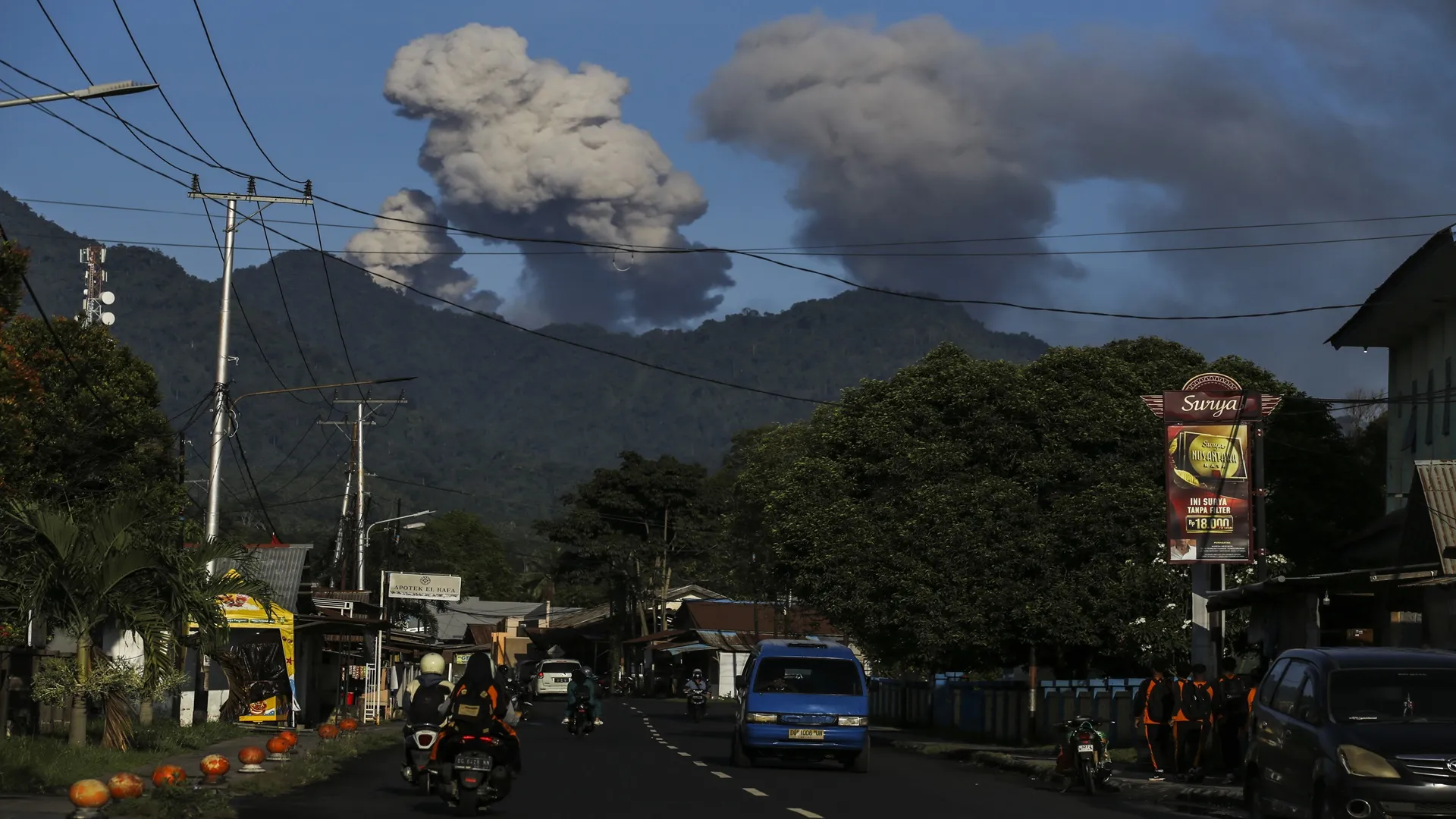

Hurricane Tracker Shows Typhoon Champi Regaining Super Typhoon Strength Before Reaching Philippines
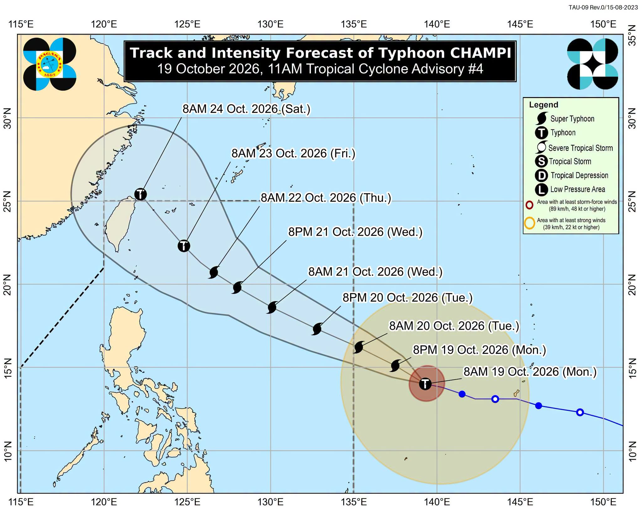
The latest hurricane tracker data indicate that Typhoon Champi has weakened into a typhoon but is forecast to re-intensify into a super typhoon before entering the Philippine Area of Responsibility on Tuesday, October 20, 2026, where it will be named Rosal, with potential impacts on Taiwan and heavy rain in northern Philippines. [1]
Current Status of Typhoon Champi
Champi was located 1,600 km east of southeastern Luzon at 10 am Monday, moving west-northwest at 20 km/h with maximum sustained winds of 175 km/h and gusts up to 215 km/h. [1] As of 8am the storm sat about 2,120 km east-southeast of Taiwan while continuing west-northwest at 21 km/h. [2] The tropical cyclone with the international name Champi weakened into a typhoon on Sunday evening, October 18. [1] Satellite imagery captured the system outside the Philippine Area of Responsibility as of October 19, 2026, 10:40 am. [1] Maximum sustained winds stood at 175 km/h with gustiness reaching 215 km/h at the Monday morning observation. [1]
Forecast Track and Re-intensification
PAGASA expects Champi to regain super typhoon status with winds of 185 km/h or higher on Monday and possibly peak at 205 km/h over the Philippine Sea before weakening from Wednesday. [1] The storm is projected to remain over the Philippine Sea heading toward Taiwan without making landfall in the Philippines but may bring heavy rain to extreme Northern Luzon and prompt tropical cyclone wind signals up to No. 3 or 4. [1] Champi is projected to enter PAR on Tuesday, October 20, where it will be given the local name Rosal. [1] Once maximum sustained winds reach 185 km/h again the system will be upgraded back to super typhoon intensity. [1] Over the Philippine Sea the future Rosal might strengthen further and reach a peak intensity of 205 km/h before gradually weakening starting Wednesday, October 21. [1] The projection for the typhoon's path remained uncertain, with the possibility that Champi may swing northward as it draws closer and miss Taiwan or continue moving westward on a direct path toward the main island. [2]
Impacts on the Philippines
The storm is projected to remain over the Philippine Sea heading toward Taiwan without making landfall in the Philippines but may bring heavy rain to extreme Northern Luzon and prompt tropical cyclone wind signals up to No. 3 or 4. [1] While Champi might spare the Philippines from landfall it is still likely to bring heavy rain to extreme Northern Luzon or the Batanes-Babuyan Islands area. [1] Champi may also prompt the raising of tropical cyclone wind signals for the northern and eastern portions of Northern Luzon and even parts of Bicol as early as Monday evening or Tuesday morning, with signals eventually reaching Signal No. 3 or 4. [1] Moderate to rough waters are expected in the northern and eastern seaboards of Luzon and the eastern seaboards of the Visayas and Mindanao on Tuesday. [1] Starting Wednesday very rough, high, or very high waters may affect the northern and eastern seaboards of Luzon. [1] Most parts of Luzon and the Visayas as well as portions of Mindanao are likely to experience gusty conditions beginning Wednesday. [1] On Monday the intertropical convergence zone and the easterlies continue to affect parts of the country, with the Zamboanga Peninsula, Basilan, Tawi-Tawi, and Palawan seeing scattered rain and thunderstorms due to the ITCZ while Bicol, Quezon, Marinduque, Romblon, and Oriental Mindoro have similar conditions because of the easterlies. [1]
Threat to Taiwan
Outer bands of Champi could affect Taiwan later this week with heavy rain and strong winds; a sea warning may be issued Wednesday night and land warning Thursday, though the track remains uncertain. [2] The outer bands of Typhoon Champi could begin affecting Taiwan later this week as the storm approaches. [2] The Central Weather Administration may issue a sea warning for the storm on Wednesday night and a land warning on Thursday. [2] Independent meteorologist Wu Der-rong said that the possibility of a direct hit on Taiwan could not be ruled out. [2] Although Champi may weaken as it approaches Taiwan the public should stay alert to the potential threats posed by heavy rain and strong winds. [2] Some areas of central and southern Taiwan could expect daytime highs of more than 36°C today as cloud cover disperses. [2]
Other Global Severe Weather Events
Separate severe weather includes an emergency declaration in Chile for a hydrometeorological event from October 18-23 and ongoing river flooding in Florida and Georgia. [3] [4] [5] On Saturday, October 17, 2026, the Director National of the Servicio Nacional de Prevención y Respuesta ante Desastres requested evaluation of a preventive emergency declaration between the regions of Coquimbo and del Biobío for the period from October 18 to October 23, 2026, given the meteorological threat forecast. [3] The Flood Warning continues for the St Johns River near Astor affecting Volusia and Lake Counties in Florida, where minor flooding is occurring and moderate flooding is forecast to reach Moderate Flood Stage early Monday and remain through the end of the week. [4] The Flood Warning also continues for the Satilla River at Atkinson affecting Brantley County in Georgia, where minor flooding is occurring and forecast to continue until further notice. [5]
What to watch next: The Central Weather Administration may issue a sea warning Wednesday night and a land warning Thursday while PAGASA monitors possible Signal No. 3 or 4 upgrades and heavy rain in extreme Northern Luzon.