
Hurricane Tracker Shows Super Typhoon Champi Entering Philippines With 185 km/h Winds
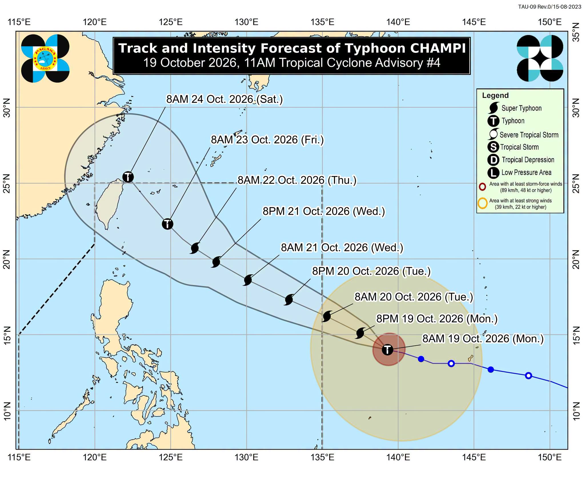
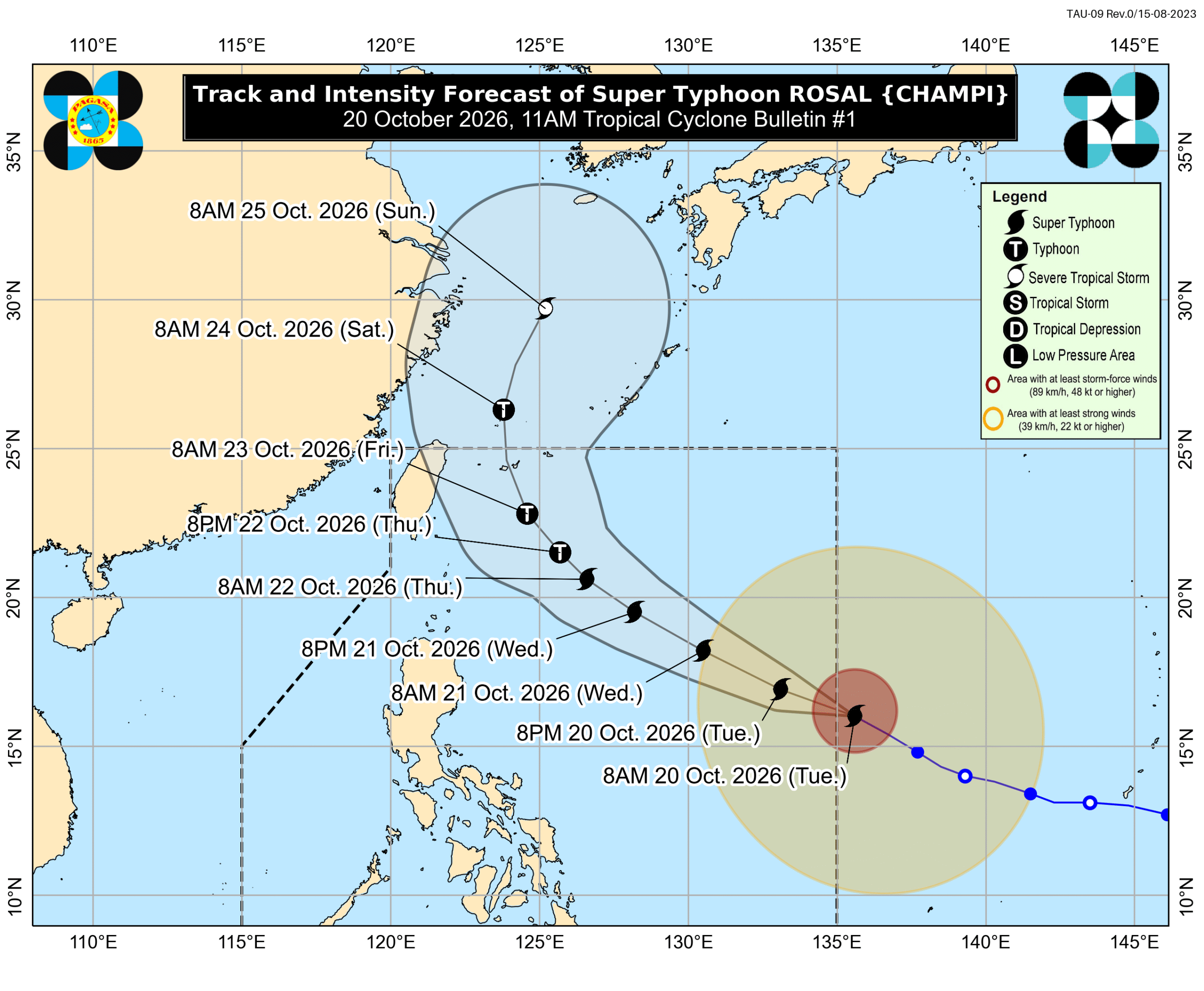
Super Typhoon Champi, locally named Rosal, entered the Philippine Area of Responsibility on October 20, 2026, as the country's 18th tropical cyclone of the year, packing maximum sustained winds of 185 km/h and gusts up to 230 km/h while triggering tropical cyclone wind signals and rough seas across multiple regions. [4] The hurricane tracker update from PAGASA placed the system 1,385 kilometers east of Central Luzon at 10 am, moving west-northwest at 25 km/h. [4]
Hurricane Tracker Shows Super Typhoon Rosal Enters Philippine Waters
Super Typhoon Champi entered the Philippine Area of Responsibility at 10:40 am on Tuesday, October 20, becoming the country’s 18th tropical cyclone for 2026 and receiving the local name Rosal. [4] At the time of entry, the system had maximum sustained winds of 185 km/h and gustiness up to 230 km/h. [4] PAGASA raised Signal No. 1 at 11 am on Tuesday in Batanes, the eastern part of Babuyan Islands including Babuyan Island, Camiguin Island and Didicas Island, the eastern part of mainland Cagayan including Santa Ana, Gonzaga, Lal-lo, Santa Teresita, Camalaniugan, Aparri, Buguey, Gattaran, Baggao and Peñablanca, the northeastern part of Isabela including Maconacon, Divilacan, Palanan, San Pablo, Cabagan, Santa Maria, Tumauini and Ilagan City, and the northeastern part of Catanduanes including Pandan, Bagamanoc, Panganiban, Viga and Gigmoto. [4] The signal provided a 36-hour lead time to prepare for strong winds, with the highest possible escalation listed as Signal No. 2 or 3. [4]
Forecast Impacts and Preparations in the Philippines
Rosal is forecast to move generally west-northwest until Wednesday, October 21, then northwest until Friday morning, October 23, before turning north-northwest to north and leaving the Philippine Area of Responsibility by Friday evening or early Saturday morning, October 24. [4] The super typhoon is unlikely to make landfall in the Philippines, yet its size and intensity will still affect parts of the country through scattered rain, thunderstorms, flash floods and landslides. [4] The northeasterly windflow and outer bands will bring strong to gale-force gusts on Tuesday, October 20, to Batanes, Ilocos Norte, Cagayan, Isabela, Polillo Islands, Camarines Norte, Camarines Sur, Catanduanes, Northern Samar, Eastern Samar, most of Caraga, Camiguin, Misamis Oriental, Sarangani, Davao del Sur and Davao Occidental. [4] On Wednesday, October 21, the gusts are expected across Ilocos Region, Cordillera Administrative Region, Cagayan Valley, Polillo Islands, Bicol, Romblon, Eastern Visayas, Iloilo, Guimaras, Negros Occidental, Siquijor, Bohol, Northern Mindanao, Caraga, Davao Region, Sarangani and Zamboanga del Norte. [4] On Thursday, October 22, most of the country faces the gusts. [4] In the next 24 hours, Rosal will produce up to very rough seas with waves up to 4.5 meters high on the northern and eastern seaboards of Catanduanes and up to rough seas with waves up to 4 meters high on the seaboard of Isabela plus eastern seaboards of Batanes, Babuyan Islands, mainland Cagayan, northern seaboards of Camarines Norte and Camarines Sur, and northern and eastern seaboards of Northern Samar and Eastern Samar. [4] Additional rain sources on Tuesday include the intertropical convergence zone affecting Palawan and the easterlies affecting Batanes and Babuyan Islands. [4]
Deadly Flooding from Extreme Weather Adam in Spain
Extreme weather system Adam produced up to 700 mm of rain in 48 hours in parts of the Valencia region. [5] Four people died, including a 79-year-old woman with reduced mobility found in her home in Oliva, a 64-year-old man who died of cardiac arrest at a campsite in the same municipality, a 55-year-old woman found dead after bathing at Almardà beach in Sagunto, and one person in Benaoján in Málaga struck by a rock. [5] More than 2,100 people were evacuated and 496 were rescued by helicopter. [5] The Guardia Civil deployed 15 helicopters and reported 1,343 personnel involved in operations across Valencia and Alicante. [5] In the Valencia region, 47 regional roads were affected and 22 smaller roads were closed due to flooding or landslides. [5] Train traffic between Valencia and Gandia and Xàtiva was halted. [5] The main airport in Ibiza closed twice after receiving 60 mm of rain in one hour, with 27 flights cancelled and 16 diverted. [5] Over 102,000 pupils in 68 municipalities were affected by school closures. [5] Agricultural organization Asaja estimated around 8,000 hectares of farmland impacted in the Valencia region alone. [5] Prime Minister Pedro Sánchez announced plans to visit the emergency command center in Oliva on Tuesday to meet emergency services and mayors from affected municipalities. [5]
El Niño Flood Warnings Raised in Somalia
Osman Yusuf Oskar, wearing a T-shirt with the letters “SUPER EL NINO,” walks the streets of Mogadishu carrying a megaphone and signs to alert residents of risks from heavy rains during the upcoming rainy season. [3] His solo campaign urges people to heed warnings that El Niño-related floods will threaten millions, primarily children. [3] The Food and Agriculture Organization has warned that strengthening El Niño conditions and forecasts of exceptionally heavy Deyr rains could raise the risk of severe flooding across Somalia, with up to a 90 percent probability of above-normal rainfall in parts of central and southern Somalia. [3] The October-December Deyr rains are forecast to be above average, increasing flood risks near major rivers. [3] After four years of drought that caused loss of livestock and crops and migration to urban areas and internally displaced persons’ settlements, communities now face additional displacement, destruction of homes and crops, and greater health risks from the rains. [3] The latest IPC analysis projects worsening acute malnutrition, estimating that 1.92 million children aged 6-59 months and 157,000 pregnant and breastfeeding women would be affected between July 2026 and June 2027. [3] UNICEF Somalia Representative Sandra Lattouf stated that a long dry spell and decreased aid had left many families without crops and other means of support, noting that kids have begun to die because of malnutrition and diseases. [3]
Winter Storm Warnings Issued in Alaska
Alaska’s National Weather Service issued a Winter Storm Warning for Tanana Flats, forecasting total snow accumulations between 5 and 10 inches from 10 AM Tuesday to 4 PM AKDT Wednesday, with travel expected to be very difficult. [1] A separate Winter Storm Warning covers Fortymile Country, where total snow accumulations of 6 to 12 inches are expected, with 1 to 3 inches from Northway to the Alcan Border along the Alaska Highway and locally higher totals of 12 to 16 inches possible between Tanacross and Dot Lake. [2] Winds could gust as high as 35 mph, and rain may mix with snow in the Upper Tanana Valley around Northway to the Alcan Border. [2] The warnings apply until 4 PM AKDT Wednesday in the affected areas including Eielson AFB, Salcha, Harding Lake, Two Rivers, Delta Junction, Fortymile Country and Upper Tanana Valley. [1][2]
Global Severe Weather Context
Multiple regions are experiencing concurrent severe weather events tracked through official alerts and monitoring systems. [1][2][3][4][5] The Philippines faces impacts from Super Typhoon Rosal while Spain deals with flooding from extreme weather Adam, Somalia prepares for El Niño-driven Deyr rains, and Alaska contends with winter storm conditions. [1][2][3][4][5] Each event carries distinct forecasts for precipitation, wind and sea state issued by the responsible meteorological authorities. [1][2][3][4][5]
What to watch next: PAGASA may issue a rainfall advisory listing areas expected to see heavy rain from Rosal, while the system is projected to possibly intensify over the Philippine Sea before weakening into a typhoon on Thursday, October 22. [4]