
Tornado Warning Issued for Uvalde, Texas, as Severe Storms Move Northeast
Severe weather is disrupting parts of the United States and Sweden, with a tornado warning issued near Uvalde, Texas, moderate flooding forecast along the Guadalupe River in Kerrville, Texas, flash flooding in south-central Texas counties, and a heatwave affecting train services across southern and central Sweden.
Tornado Threat in Uvalde, Texas
At 235 AM CDT a severe thunderstorm capable of producing a tornado was located near Uvalde Estates, or 8 miles southwest of Uvalde, moving northeast at 5 mph. [2] The hazard is a tornado, with the source identified as radar indicated rotation. [2] Impacts include flying debris that will be dangerous to those caught without shelter. [2] Mobile homes will be damaged or destroyed. [2] Damage to roofs, windows, and vehicles will occur. [2] Tree damage is likely. [2] Locations impacted include Uvalde Estates. [2] The movement of the storm at a slow pace of 5 mph allows time for residents to seek shelter before the system arrives. [2] Radar detection of rotation provides confirmation that rotation is present within the thunderstorm cell. [2] People without shelter face direct exposure to flying debris carried by strong winds associated with the tornado threat. [2]
Moderate Flooding Along Guadalupe River
Forecast flooding changed from minor to moderate severity and increased in duration for the Guadalupe River at Kerrville affecting Kerr County. [3] Moderate flooding is forecast. [3] The location is the Guadalupe River at Kerrville. [3] The timing extends until late this afternoon. [3] Impacts at 17.0 feet include flow that reaches the first floor of a resort and restaurant upstream left bank. [3] This level is near the USGS 1:10 year flood. [3] At 2:20 AM CDT Thursday the stage was 8.8 ft. [3] The upgrade to moderate severity reflects expectations that water levels will rise enough to affect structures along the riverbank. [3] The duration through late afternoon means the resort and restaurant could experience water intrusion on the first floor if the river reaches the projected height. [3] The current stage reading of 8.8 ft indicates the river has not yet reached the impact threshold but is under watch as it continues to rise. [3]
Flash Flooding in South-Central Texas
A flash flood warning remains in effect until 530 AM CDT for western Bandera County, northwestern Kerr County, and southeastern Real County in south central Texas. [5] At 221 AM CDT Doppler radar indicated thunderstorms producing heavy rain across the warned area. [5] Between 3 and 12 inches of rain have fallen over the last two days. [5] Additional rainfall amounts up to 4 inches are possible. [5] The combination of already saturated ground from prior rainfall and the potential for more rain increases the risk of flash flooding in these counties. [5] Doppler radar continues to track the thunderstorms that are generating the heavy precipitation. [5] The warning covers a specific portion of south central Texas where the rainfall totals have already been substantial. [5]
Heatwave Disrupts Swedish Rail Services
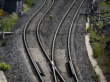
Many parts of Sweden are now going through a heatwave. [1] Weather bureau SMHI has a yellow warning in place for high temperatures covering much of southern and central Sweden, as well as the southernmost parts of northern Sweden. [1] The heat can cause railway tracks to buckle, and train services have been impacted. [1] The yellow warning signals conditions that require attention from rail operators across the affected regions. [1] Buckling of tracks under high temperatures can lead to speed restrictions or cancellations on affected lines. [1] The warning area spans southern and central Sweden plus the southernmost parts of northern Sweden. [1]
Flooding Ends in Hot Springs, Wyoming
Heavy rain has ended and additional flooding is no longer expected to pose a threat. [4] Residents should continue to heed remaining road closures. [4] The end of the flash flood warning follows the cessation of the heavy rainfall that triggered it. [4] Road closures that remain in place require continued observance even though the immediate flood threat has passed. [4]
What to watch next includes continued monitoring of the Guadalupe River stage at Kerrville through late afternoon, any additional rainfall up to 4 inches in the warned Texas counties, and the status of rail services in Sweden under the ongoing yellow high-temperature warning.