Hurricane Tracker Shows Pilandok Holding Steady East of Philippines as Monsoon Brings Heavy Rain
The hurricane tracker shows Tropical Depression Pilandok maintaining strength east of the Philippines while an enhanced southwest monsoon brings heavy to intense rainfall along with flash flood and landslide risks to multiple regions including Ilocos, Abra and Benguet.
Pilandok and the Enhanced Southwest Monsoon
Tropical Depression Pilandok is located 1,145 km east of extreme Northern Luzon and is moving north northwest at 10 km/h with sustained winds of 55 km/h and gusts to 70 km/h. [4] It is forecast to intensify into a tropical storm by September 1 but remains unlikely to make landfall in the Philippines. [4] Two additional tropical depressions outside the Philippine Area of Responsibility are enhancing the southwest monsoon and causing monsoon rains along with strong to gale-force winds and rough seas across Luzon and parts of Visayas. [4] Tropical Depression Saudel, located 1,075 km west of extreme Northern Luzon, has winds of 45 km/h and gustiness up to 75 km/h. [4] The other tropical depression, located 570 km west northwest of Itbayat, Batanes, has winds of 45 km/h and gustiness up to 60 km/h. [4] Pilandok may become almost stationary over the Philippine Sea east of extreme Northern Luzon for the next 36 hours before moving generally north northwestward. [4] It is still less likely to make landfall and will remain far from the Philippine landmass. [4] Pilandok may intensify into a tropical storm by Tuesday, September 1, before it leaves the Philippine Area of Responsibility and moves toward southern Japan. [4] The enhanced southwest monsoon is bringing monsoon rain to Ilocos Region, Abra, and Benguet and occasional rain to the rest of the Cordillera Administrative Region, Batanes, Nueva Vizcaya, Bataan, Zambales, Tarlac, Pampanga, and Nueva Ecija. [4]
Heavy Rainfall Outlook for Luzon
Heavy to intense rainfall of 100-200 mm is forecast for Ilocos Sur, La Union, Abra and Benguet over the next three days, with moderate to heavy rain in additional provinces including Zambales, Pangasinan and Occidental Mindoro. [4] From Monday afternoon, August 31, to Tuesday afternoon, September 1, heavy to intense rain of 100-200 mm is expected in Ilocos Sur, La Union, Abra, and Benguet while moderate to heavy rain of 50-100 mm is forecast for Ilocos Norte, Pangasinan, Batanes, Apayao, Kalinga, Ifugao, Mountain Province, Nueva Vizcaya, Tarlac, Nueva Ecija, Pampanga, Zambales, and Bataan. [4] From Tuesday afternoon, September 1, to Wednesday afternoon, September 2, heavy to intense rain of 100-200 mm is expected in Ilocos Sur, La Union, Abra, Benguet, and Zambales while moderate to heavy rain of 50-100 mm is forecast for Ilocos Norte, Pangasinan, Apayao, Kalinga, Mountain Province, Tarlac, Pampanga, and Bataan. [4] From Wednesday afternoon, September 2, to Thursday afternoon, September 3, heavy to intense rain of 100-200 mm is expected in Benguet, Zambales, Bataan, and Occidental Mindoro while moderate to heavy rain of 50-100 mm is forecast for Ilocos Norte, Ilocos Sur, Abra, La Union, Pangasinan, Tarlac, Nueva Ecija, Pampanga, Bulacan, Cavite, and Batangas. [4] These areas should watch out for flash floods and landslides. [4]
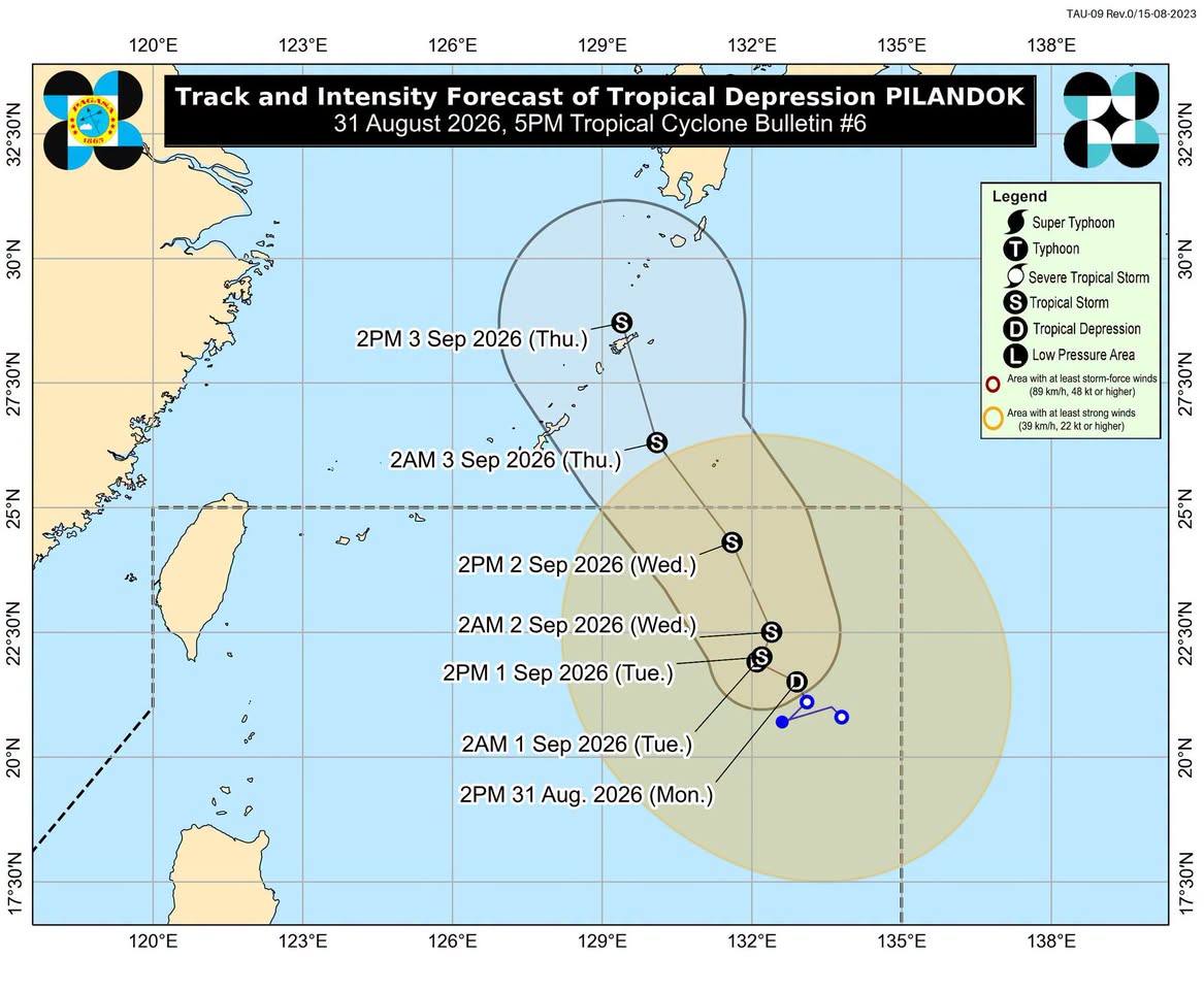
Tropical Depression Pilandok maintains strength east of the Philippines as enhanced southwest monsoon brings heavy rain to Luzon. — Source: rappler
Wind, Sea Conditions and Travel Impacts
The enhanced southwest monsoon is also bringing strong to gale-force gusts over most of the country on Monday, August 31, and over most of Luzon and Visayas plus Zamboanga del Norte, Misamis Occidental, Lanao del Norte, Misamis Oriental, Camiguin, Dinagat Islands, Davao Occidental, and Davao Oriental on Tuesday, September 1, until Wednesday, September 2. [4] Moderate to very rough seas will persist in several areas. [4] Up to very rough seas with waves up to 4.5 meters high affect the western seaboards of Babuyan Islands and Ilocos Norte, where travel is risky for all vessels. [4] Up to rough seas with waves up to 4 meters high affect the seaboards of Batanes and northern Ilocos Sur along with the northern seaboard of Babuyan Islands, where small vessels should not venture out to sea. [4] Up to rough seas with waves up to 3.5 meters high affect the seaboards of northern La Union and Zambales, the western seaboards of Pangasinan and Bataan, and the remaining seaboard of Ilocos Sur. [4] Up to rough seas with waves up to 3 meters high affect the western seaboards of Cavite, Batangas, Lubang Islands, northern Occidental Mindoro, and Calamian Islands along with the southern seaboard of Bataan and the northern and western seaboards of Kalayaan Islands. [4] Up to moderate seas with waves up to 2.5 meters high affect the western seaboard of northern Palawan, the eastern seaboard of Davao Oriental, the remaining seaboards of Babuyan Islands and Kalayaan Islands, and the remaining western seaboard of Occidental Mindoro. [4] Up to moderate seas with waves up to 2 meters high affect the seaboards of Isabela, Romblon, Cuyo Islands, Antique, Surigao del Sur, and Davao Occidental along with the western seaboards of Burias Island and Negros Occidental, the southern seaboards of Marinduque and Quezon, the remaining western seaboard of mainland Palawan, and the remaining seaboards of Davao Oriental, La Union, and Pangasinan. [4]
U.S. Severe Weather Alerts
Separate severe weather includes an ongoing flash flood warning in Pima, Arizona due to thunderstorms producing 1-2 inches of rain. [1] At 443 AM MST, Doppler radar and automated rain gauges indicated thunderstorms producing heavy rain across the warned area, with between 1 and 2 inches of rain having fallen. [1] The AZGFD3 and Diamond Bell Ranch alert gauges recorded 1.5 inches in the last hour and a half. [1] Flash flooding is ongoing or expected to begin shortly, with the hazard consisting of flash flooding caused by thunderstorms. [1] A Red Flag Warning is also in effect for portions of the Klamath National Forest in California and Oregon with gusty winds and low humidity. [2] The affected area includes the Scott Valley in Fire weather zone 280, Fire weather zone 281, Fire weather zone 284 excepting the southeast portion of the zone, and Fire weather zone 285 in California along with Fire weather zone 624 excepting the Highway 97 corridor from Modoc Point to Chemult in Oregon. [2] South winds of 10 to 20 mph with gusts to 30 mph are expected in the Scott Valley, while 15 to 25 mph winds with gusts to 35 mph are forecast in the Shasta Valley and elsewhere southwest winds of 10 to 20 mph with gusts to 30 mph. [2]
Heat and Water Crisis in Gaza
Extreme heat is worsening the water shortage caused by damage to 90% of Gaza’s water and sanitation infrastructure. [3] In Gaza, securing drinking water remains a relentless daily struggle as the war with Israel has destroyed critical water and sanitation infrastructure. [3] As temperatures soar, the extreme heat is escalating an already severe shortage into a deadly humanitarian crisis. [3] Two and a half years of war with Israel have damaged or destroyed nearly 90% of Gaza’s water and sanitation infrastructure according to UNICEF. [3]
Additional Regional Weather Notes
Lombardy suffers further damage from storms as part of the broader global severe weather picture. [5] The hurricane tracker continues to monitor developments across multiple regions while the enhanced southwest monsoon and separate alerts remain active. [4]
What to watch next: Pilandok may intensify into a tropical storm by Tuesday, September 1, before leaving the Philippine Area of Responsibility, while the two external tropical depressions continue enhancing the southwest monsoon with ongoing risks of heavy rain, strong winds, and rough seas.