
Tornado Tracker Shows Severe Thunderstorms Moving Through Virginia and Maryland
Tornado tracker observations confirm severe thunderstorms with damaging winds and hail are impacting parts of Virginia and Maryland on Wednesday afternoon, while Tropical Storm Pilandok and the southwest monsoon continue to drive heavy rain, strong winds and haze risks across the Philippines.
Tornado Tracker Active Severe Thunderstorm Warnings in the United States
A Severe Thunderstorm Warning is in effect for Clarke, VA, with a storm near Berryville moving south at 20 mph, bringing 60 mph wind gusts and quarter-size hail that could down trees, damage homes and vehicles, and cause power outages. [1] Radar indicated the hazard includes 60 mph wind gusts and quarter size hail. [1] The impact involves damaging winds that will cause some trees and large branches to fall, which could injure those outdoors as well as damage homes and vehicles. [1] Roadways may become blocked by downed trees and localized power outages are possible. [1] Unsecured light objects may become projectiles. [1]
A Severe Thunderstorm Warning covers Kent, MD, with storms moving east at 40 mph along a line from near Cecilton to Overton, producing 60 mph wind gusts capable of damaging roofs, siding, trees and power lines. [2] Radar indicated the hazard includes 60 mph wind gusts. [2] The impact includes possible damage to roofs, siding, trees, and power lines. [2] Locations impacted include Centerville, Chestertown, Centreville, Romancoke, Rock Hall, Church Hill, Millington, Sudlersville, Old Town, Grasonville, Morgnec, Crumpton, Sassafras, Stevensville, Langford, Chester, Overton, Starkey Corner. [2] These warnings highlight immediate risks from the line of storms crossing the region at the stated speeds.
Tropical Storm Pilandok and Southwest Monsoon in the Philippines
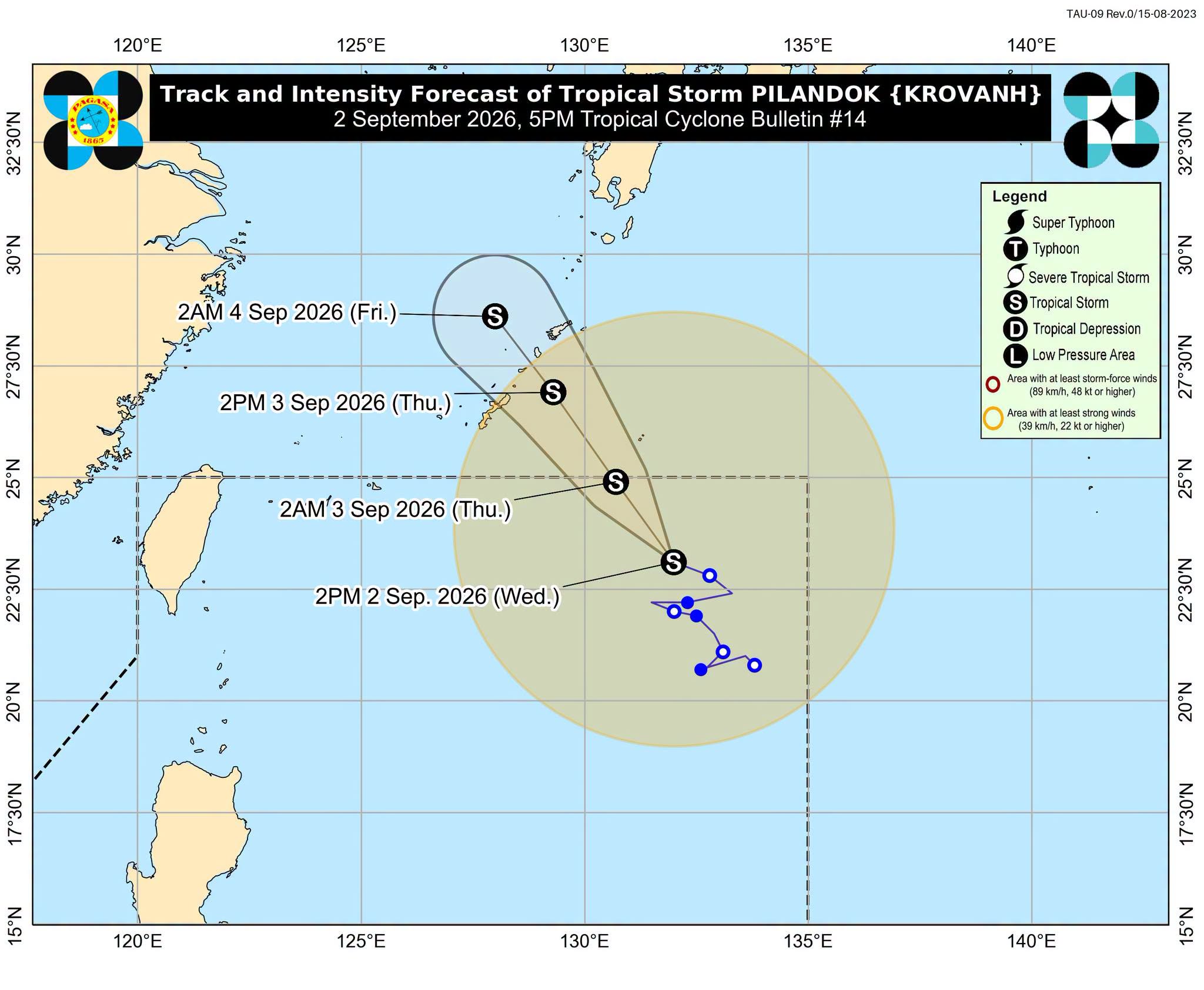
Tropical Storm Pilandok, located 1,085 km east northeast of extreme Northern Luzon and moving west northwest at 14 km/h with 65 km/h winds, is enhancing the southwest monsoon and is forecast to exit the Philippine Area of Responsibility by early September 3 without making landfall. [3] The tropical storm was last located 1,085 kilometers east northeast of extreme Northern Luzon, moving west northwestward at 14 kilometers per hour, with maximum sustained winds of 65 km/h and gustiness of up to 80 km/h. [3] It still has no direct effect on the country, far from the Philippine landmass, and is unlikely to make landfall, remaining over the northern Philippine Sea as it moves toward Okinawa, Japan. [3]
Tropical Storm Saudel is gradually weakening while moving toward southern China and is unlikely to reenter the Philippine Area of Responsibility, though Hong Kong’s observatory is monitoring it for possible higher typhoon signals later in the week as it may edge closer to the Pearl River Delta. [3] Saudel was located 460 km west northwest of Itbayat, Batanes, with winds of 65 km/h and gustiness of up to 80 km/h, moving east northeastward at 20 km/h. [3] PAGASA Weather Specialist Benison Estareja said Saudel is gradually weakening as it moves toward southern China, and there is a high chance that the tropical storm will no longer enter PAR. [3]

Severe thunderstorms with damaging winds and hail move through Virginia and Maryland. — Source: scmp
Forecast Rain, Flood and Landslide Risks
The southwest monsoon is producing moderate to heavy rain in multiple Philippine provinces including Ilocos Norte, Ilocos Sur, La Union, Pangasinan, Abra, Benguet, Zambales and Bataan, with flood and landslide risks, plus strong to gale-force gusts and rough seas in coastal areas. [3] Ilocos Norte, Ilocos Sur, La Union, Pangasinan, Abra, Benguet, Zambales, and Bataan are seeing moderate to heavy rain on Wednesday afternoon due to the southwest monsoon. [3] The rain will ease in some provinces and affect only Zambales, Bataan, Cavite, Batangas, and Occidental Mindoro on Thursday afternoon before heavy to intense rain is seen again in Occidental Mindoro and moderate to heavy rain in Zambales, Bataan, Pampanga, Cavite, Batangas, Oriental Mindoro, and Antique on Friday afternoon. [3] These provinces should watch out for floods and landslides. [3]
Monitoring of Saudel and Regional Outlook
Hong Kong’s weather forecaster could issue a higher typhoon signal closer to the weekend after Tropical Cyclone Saudel experienced a rare resurgence, with the potential to change course over the South China Sea and edge towards the Pearl River Delta. [5] The Observatory said the No 1 typhoon signal would remain in force for the rest of Wednesday and into Thursday morning, as Saudel was expected to linger over the northeastern South China Sea and remain about 300km or more from Hong Kong. [5] Under the combined effect of Saudel and the northeast monsoon, local winds are occasionally strong offshore and on high ground. [5] Saudel is expected to gradually turn westwards on Thursday and skirt the coast of eastern Guangdong, bringing uncertainty in the days that followed. [5] It will edge closer to the vicinity of the Pearl River Estuary again on Friday. [5] There will be rather large uncertainties over its intensity by then. [5] The Observatory will closely monitor Saudel’s movement and assess the need to issue the strong wind signal No 3 as it edges closer to the Pearl River Delta. [5] Occasional heavy rain and strong winds due to the southwest monsoon and LPAs remain prevalent in September, but easterlies may prevail toward the end of the month. [3] Two to three tropical cyclones are expected to enter PAR in September. [3]
What to watch next: The No 1 signal is expected to remain in force for the rest of Wednesday and into Thursday morning while PAGASA monitors the low pressure area 2,745 km east of Central Luzon for any development.