/file/attachments/orphans/BM-Ed-ElNinoAucamp3_433491.jpg)

Hurricane Tracker Shows Trudy Rapidly Intensifying Toward Mexico’s Jalisco Coast
The hurricane tracker shows Hurricane Trudy has formed in the eastern Pacific and is forecast to rapidly intensify into a major hurricane threatening Mexico’s Jalisco coast this weekend, while a super El Niño is expected to bring severe drought to South Africa, push coral reefs closer to extinction, and exacerbate global severe weather risks. [2] Hurricane Trudy became a hurricane with 75 mph sustained winds and is undergoing rapid intensification while moving northwest, expected to bring 4-8 inches of rain to Colima and Jalisco. [2]
Hurricane Trudy Forms and Intensifies Toward Mexico
Hurricane Trudy became a hurricane before dawn Thursday. [2] The storm system was located about 300 miles southwest of Acapulco and 445 miles south-southeast of Manzanillo, Colima, while registering maximum sustained winds of 75 mph, with gusts of 93 mph. [2] According to the U.S. National Hurricane Center, Trudy is undergoing a period of rapid intensification as it moves northwest at 9 mph and is expected to bring heavy rains to Oaxaca and Guerrero today. [2] Forecast models project it will become a major hurricane as it approaches the coast of southwestern and west-central Mexico this weekend, bringing rainfall of 4 to 8 inches through the weekend across Colima and Jalisco states. [2] The hurricane tracker indicates the current location and the projected course of Hurricane Trudy through next Tuesday, during which time it is expected to strengthen. [2] While Pacific Coast residents are still reeling from the passage of Polo, Rachel and Simon, the newly formed Hurricane Trudy threatens to bring more chaos and disruption to the region. [2]
Ongoing Toll From Preceding Storms Rachel, Polo and Simon
Eight deaths have been attributed to Hurricane Rachel, while at least four people remain missing and the military has been actively carrying out search and rescue operations. [2] Simon, lurking near the Jalisco coast south of the tip of the Baja California Peninsula, is expected to remain a Category 1 hurricane through Friday. [2] Simon remains virtually frozen a few hundred kilometers west-southwest of Cabo Corrientes, Jalisco, and is expected to continue orbiting in place with sustained winds of 75 mph and gusts of 95 mph. [2] Sustained winds were about 130 miles per hour as the week began, and the storm’s inner core was brushing up against the Jalisco coast. [2] The topography of the Sierra Madre mountains appeared to temper Simon’s intensity and shrink the size of its wind field. [2] Still, as the storm system weakened from a Category 4 to Category 1 it delivered heavy rain and flooding to coastal areas, including the port city of Manzanillo, Colima. [2] Last month, Polo — the second most-intense Pacific hurricane on record — made consecutive landfalls on the peninsula and then mainland Mexico on Sept. 29. [2] President Claudia Sheinbaum on Thursday activated the Defense Ministry’s DN-III emergency protection plan and the Navy’s Plan Marina. [2] Sheinbaum also ordered the Interior Ministry to stay in close contact with the Baja California governor in order to provide any support that may be needed, especially as Simon is expected to move toward the peninsula on Saturday. [2]
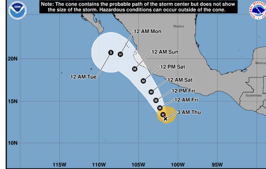
Hurricane Trudy intensifies in the eastern Pacific as it heads toward Mexico’s Jalisco coast. — Source: mexiconewsdaily
Super El Niño Drought Warning for South Africa
As a super El Niño threatens South Africa’s farming sector and the wider economy with drought and potential water shortages, Agriculture Minister Willie Aucamp has warned against complacency. [1] Much of South Africa’s summer rainfall region got decent rains in September, an additional layer of security to good soil moisture and dam levels. [1] But El Niño only typically gains traction here once summer is fully under way. [1] “We are very much concerned. We had a bit of rain now in September, but I tell farmers, ‘Please, do not be deceived that this is not going to happen.’ Some of our farmers are planting now, and I think we are going to have a very hot and dry November, December and January,” Aucamp told Daily Maverick on the sidelines of the AgriSA congress on Wednesday in Irene. [1] “We’ve got early-warning systems, but this is going to be next level.” [1] El Niño usually triggers drought in this region, and the latest event is widely regarded as the strongest on record. [1] It is expected to last until at least February. [1] Aucamp is concerned about the timing of water-use restrictions. [1] “We should not wait for this to be declared a disaster before municipalities put in water restrictions, and then it spills over and farming communities get less water. I think we need to be proactive in implementing water restrictions from the municipalities’ side,” he said. [1]
Coral Reefs Face Heightened Extinction Risk
A potentially record-breaking super El Niño could push the world’s fragile coral reefs closer to extinction as ocean temperatures soar to unprecedented levels, David Obura, chair of the UN’s expert scientific panel on biodiversity, has warned. [5] In an interview with news agency AFP, Obura, a Kenyan marine scientist and coral reef expert who chairs the Intergovernmental Science-Policy Platform on Biodiversity and Ecosystem Services, said the developing climate phenomenon posed a major additional threat to already vulnerable coral species. [5] “This year's El Niño layers a terrifying level of additional risk,” Obura said. [5] Corals are highly sensitive to heat and particularly vulnerable to climate change, which is warming the world’s oceans and increasing the frequency and intensity of damaging bleaching events. [5] The developing El Niño in the tropical Pacific could intensify these pressures, putting some coral species at greater risk of extinction. [5] El Niño is the warming phase of a natural climate cycle that temporarily raises global temperatures and alters cloud and wind patterns, increasing the risk of damaging weather events. [5] Global forecasters expect the current episode to be the strongest on record, while sea surface temperatures in parts of the Pacific have already reached all-time highs months before its anticipated peak. [5] Obura recalled the devastating effects of the 1997-98 super El Niño, warning that the approaching event could be even more damaging after several major global coral bleaching episodes. [5] “That this coming event is worse than that, after three intervening global bleaching events ... is a terrifying reality,” he said. [5] Obura led a major reassessment of coral health published in the journal Nature on Thursday. [5] The study found a sharp deterioration in the condition of reef-building coral species since the previous global assessment in 2008. [5] “Our results show that by 2020, nearly half of coral species were at elevated relative risk of extinction” with climate change the main driver of this decline, Obura and dozens of other scientists wrote. [5] The review examined hundreds of species on the International Union for Conservation of Nature's Red List, including staghorn and table corals. [5]
U.S. Severe Weather Alerts Amid Broader Pattern
A Red Flag Warning is in effect for parts of Northern California with low humidity and winds that could cause rapid fire spread. [3] The warning covers fire weather zones including Lake Pillsbury, the City of Clearlake, Middletown, Lower Lake, and Indian Valley Reservoir, and including Cobb and Mount Konocti. [3] Sustained winds of 15 to 25 mph with gusts to 35 mph are possible in exposed areas. [3] Humidity shows low overnight recoveries of 30-35% that will drop to 10-20% through the morning, with very poor relative humidity recovery into Friday. [3] Any fires that develop will likely spread rapidly. [3] A Flash Flood Warning has been issued for parts of Nolan and Taylor counties in Texas. [4] The National Weather Service in San Angelo has issued the warning for southeastern Nolan County in west central Texas and southwestern Taylor County in west central Texas until 700 PM CDT. [4] At 359 PM CDT, Doppler radar indicated thunderstorms producing heavy rain across the warned area. [4] Between 2 and 3 inches of rain have fallen, with additional rainfall amounts up to 1 inch possible in the warned area. [4] Flash flooding is ongoing or expected to begin shortly. [4]
Broader Agricultural and Environmental Preparations
Aucamp said the department was advising farmers to focus on their most fertile sections of land and not plant in marginal areas. [1] Most commercial farmers are probably doing so anyway, guided by high-tech and capital-intensive tools such as precision farming, which enables the precise distribution of inputs based on soil quality using GPS. [1] This is a key reason behind the surge in South African crop yields, rain or shine, in recent decades. [1] The first indication of the amount of land that will be devoted to summer grain crops, including maize, will come on 27 October when the government’s Crop Estimates Committee will provide its first estimate on farmers’ planting intentions. [1] Surging fuel and fertiliser prices triggered by the Ukraine and Iran wars will be a constraint. [1] Aucamp said that fertiliser prices had soared by more than 300% since Russia's 2022 invasion of Ukraine. [1] Turning to livestock, Aucamp said farmers would have to reduce their herd numbers to prevent overgrazing. [1] A smaller national cattle herd will also reduce the number of vaccines required to contain the foot-and-mouth disease outbreak. [1] On that front, Aucamp said that 70% of the national herd of more than 13 million animals has been vaccinated to date and that the goal of 80% by the end of this year was in reach. [1] “If you’ve got a cow that’s not giving you a calf any more, or a cow that’s not giving the proper amount of milk any more, get rid of that animal. Rather have less stock but stock of good quality. We can always build up that stock again.” [1] Amid all the focus on El Niño and foot-and-mouth disease, other agriculture issues such as the politically thorny one of land reform have faded on the public’s radar screen. [1] But Aucamp, who assumed the agriculture portfolio 3½ months ago, said it was a priority of his. [1] “We are busy with a project where we are identifying 100 farms per province, black farmers who are currently renting their farms from government, to transfer the land into their names, and this is just the start,” he said. [1] “They must have title deeds. We must see that land gets out of the hands of the government. You’re not going to invest in a farm if it’s not yours. You can use it as collateral to obtain finance,” he said. [1]
What to watch next: Forecast models project Hurricane Trudy will become a major hurricane as it approaches the coast this weekend, Simon is expected to remain a Category 1 hurricane through Friday, and the super El Niño is expected to last until at least February with hot and dry conditions in November through January.