
Hurricane Tracker Shows Saudel and Krovanh Far from Taiwan as Heavy Rain Alerts Cover Island
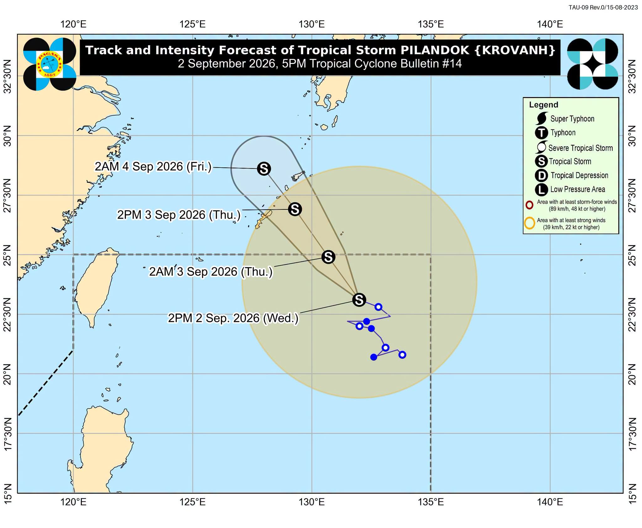
Severe weather is affecting multiple regions globally with heavy rain alerts in Taiwan, flash flooding in Texas, and severe thunderstorms producing damaging winds and hail in Pennsylvania and Michigan. A hurricane tracker shows the positions of two tropical storms far from the island while moisture fuels local convection.
Taiwan Heavy Rain Alerts Issued
The Central Weather Administration issued heavy rain advisories for parts of northern and southern Taiwan effective through the night. Heavy rain defined as more than 80 mm of rainfall in 24 hours or 40 mm in one hour is expected in Keelung and other areas along the north coast, Yilan, Pingtung and Taitung counties, mountainous areas in Taipei and New Taipei City, and on Orchid Island and Green Island. Other parts of Taiwan can expect showers or thundershowers today as well as into the night. High levels of moisture around Taiwan could trigger severe convection accompanied by thunder, strong winds and sudden heavy downpours most likely in southwestern and northeastern Taiwan. [1]
Tropical Storms Monitored but No Direct Taiwan Impact
The hurricane tracker shows two tropical storms over the northeastern Pacific named Saudel and Krovanh that are not expected to directly affect Taiwan today or tomorrow. High levels of moisture around Taiwan could still trigger severe convection accompanied by thunder, strong winds and sudden heavy downpours most likely today in southwestern and northeastern Taiwan. The Central Weather Administration noted that heavy rain defined as more than 80 mm of rainfall in 24 hours or 40 mm in one hour remains possible in Keelung and other northern and southern locations. [1]
Ongoing Flooding in Southeastern Texas
Flooding caused by excessive rainfall is ongoing in southwestern Polk County and central San Jacinto County in southeastern Texas until 4:45 AM CDT. Low-water crossings are inundated with water and may not be passable especially along FM 3128 northeast of Coldspring and SH 150 west of Shepherd. A Flash Flood Warning covers northwestern Hardin County until 1:00 AM CDT with Doppler radar and automated rain gauges indicating thunderstorms producing heavy rain west of Kountze where between 3 and 7 inches of rain have fallen and additional rainfall amounts of 1 to 2 inches are possible. Flash flooding is already occurring in the warned area. [2] [5]
Severe Thunderstorms Strike Pennsylvania Counties
The National Weather Service in State College has issued a Severe Thunderstorm Warning for northeastern Clearfield County, Cameron County, northwestern Clinton County, Elk County, northwestern Lycoming County, southeastern McKean County, Potter County and southwestern Tioga County. The warning covers threats of damaging winds and hail across these north central Pennsylvania counties. [3]
Damaging Storms Move Through Michigan
At 11:42 PM EDT severe thunderstorms were located along a line extending from 8 miles south of Belle Isle to near Greenfield Village to near Hamburg moving southeast at 30 mph. Hazards include 60 mph wind gusts and quarter size hail according to radar indicated sources. These storms will be near Livonia, Taylor, Romulus, Canton, Dearborn, Wyandotte, Northville, Salem, Greenfield Village and Whitmore Lake with expected hail damage to vehicles and wind damage to roofs, siding and trees. [4]
Weekend Outlook for Taiwan
Over the weekend weather conditions are expected to remain unstable across Taiwan with a possibility of localized showers nationwide and afternoon thunderstorms in central and southern Taiwan. Rain in southwestern Taiwan is expected to ease from Monday through Wednesday next week while northern and eastern Taiwan might experience some showers. [1]
What to watch next: High moisture levels may continue to trigger severe convection with thunder, strong winds and sudden heavy downpours in southwestern and northeastern Taiwan while flooding remains ongoing in southeastern Texas counties and severe thunderstorm warnings stay active in Pennsylvania and Michigan.