Hurricane Tracker Shows New Storm Forming Off Mexico as Taiwan Recovers from Typhoon Champi
Multiple regions worldwide are experiencing severe weather impacts including flooding in the southwestern United States, heavy rainfall forecasts across Kenya, and the passage of Typhoon Champi that brought damaging winds and torrential rain to Taiwan, while a new hurricane threat is forming off Mexico's coast as highlighted by ongoing hurricane tracker monitoring. Flood warnings remain in effect for parts of southwestern Colorado and southeastern Utah due to excessive rainfall causing flooding of rivers, creeks, streams and low-lying areas, with multiple road closures in Archuleta County and the San Juan River projected to continue rising through Bluff and Mexican Hat. Kenya's Meteorological Department has warned of heavy rainfall exceeding 20mm in 24 hours, flash floods, strong winds exceeding 25 knots and ocean waves over two metres from October 24-28 in counties including Nairobi, Mombasa, Kilifi, Garissa, Kisumu and others, with intensity expected to reduce by October 30. Typhoon Champi, once a super typhoon with gusts near 191 kph, brought up to 900mm of forecast rain in mountainous areas of Taiwan, causing one death, 350 injuries, over 2,600 evacuations, widespread power outages affecting more than 77,000 households, cancellation of all domestic and most international flights, and road closures. A new storm is forming off Mexico's coast amid broader severe weather concerns in Latin America and the Caribbean that have displaced 20,000 people in Haiti due to violence and left 5,000 in shelters after a 7.5 magnitude earthquake in Panama. Cumulative rainfall from Champi exceeded 500mm at some Taiwan stations reaching extremely torrential levels, with the storm expected to pass near northeastern Taiwan, turn north toward China and then southern Japan.
Ongoing Flooding in Southwestern Colorado and Utah
Flood warnings remain in effect for parts of southwestern Colorado and southeastern Utah due to excessive rainfall causing flooding of rivers, creeks, streams and low-lying areas, with multiple road closures in Archuleta County and the San Juan River projected to continue rising through Bluff and Mexican Hat. [1] Flood Warning details indicate that flooding caused by excessive rainfall continues in Western Archuleta County in southwestern Colorado, Southern Hinsdale County in southwestern Colorado, and Southern La Plata County in southwestern Colorado until 400 PM MDT. [1] Impacts include flooding of rivers, creeks, streams, and other low-lying and flood-prone locations that is occurring, with streams levels remaining elevated due to excess runoff from earlier rainfall and multiple road closures in effect county wide. [1] Similar conditions apply in West Central Montezuma County in southwestern Colorado and Southeastern San Juan County in southeastern Utah along the San Juan River from the Four Corners to Lake Powell, where the warning extends until 345 PM MDT. [2] Flooding of rivers, creeks, streams, and other low-lying and flood-prone locations is occurring in these areas as well, and the San Juan River will continue to rise this afternoon through Bluff and Mexican Hat with the projected peak occurring around the noted timeframe. [2] These ongoing conditions underscore the persistent risks from excessive rainfall across the affected southwestern regions.
Kenya Prepares for Heavy Rains and Flash Floods
Kenya's Meteorological Department has warned of heavy rainfall exceeding 20mm in 24 hours, flash floods, strong winds exceeding 25 knots and ocean waves over two metres from October 24-28 in counties including Nairobi, Mombasa, Kilifi, Garissa, Kisumu and others, with intensity expected to reduce by October 30. [4] The advisory issued on October 23 states that rainfall exceeding 20mm within 24 hours is expected in parts of the Coast, Northeastern region, the Highlands West and East of the Rift Valley, Central Highlands and Southeastern Lowlands from October 24 to 28, with parts of Nairobi among the areas expected to receive rain alongside Mombasa, Kilifi, Kwale, Garissa, Wajir, Mandera, Kisumu, Nakuru, Kiambu, Machakos, Kajiado, Meru and Nyeri among other counties. [4] Residents in all the mentioned areas should remain vigilant for potential flash floods and poor visibility, as the department warned that floodwaters can also occur downstream in areas that have not received heavy rainfall. [4] The rains are also expected to be accompanied by gusty winds, with strong southerly to southeasterly winds exceeding 25 knots forecast in coastal, eastern and northern regions, and ocean waves exceeding two metres expected on Sunday, October 25, prompting a warning to people involved in maritime activities to exercise caution. [4] Residents have also been advised to avoid sheltering under trees or staying near grilled windows during storms because of the risk of lightning strikes, while the rainfall intensity is expected to reduce by October 30 according to the department which said further updates would be issued if conditions change. [4]
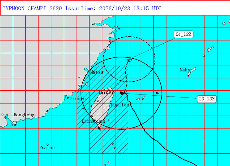
Typhoon Champi brings damaging winds and torrential rain to Taiwan. — Source: taipei-times
Typhoon Champi Brings Damage and Disruption to Taiwan
Typhoon Champi, once a super typhoon with gusts near 191 kph, brought up to 900mm of forecast rain in mountainous areas of Taiwan, causing one death, 350 injuries, over 2,600 evacuations, widespread power outages affecting more than 77,000 households, cancellation of all domestic and most international flights, and road closures. [5] At one point a super typhoon and one of the strongest storms in the Pacific this year, Champi was packing gusts of about 191kph near its center as of 8:30pm, the CWA said, with cumulative rainfall at the Taipingshan weather station in Yilan County exceeded 500mm as of 7pm yesterday reaching the extremely torrential rain level. [5] Rainfall at the Cuifeng Lake and Cuifeng Forest Road stations, which ranked second and third respectively, exceeded 400mm approaching the same threshold, and the CWA forecast that from Thursday when Champi began affecting Taiwan through midnight tonight cumulative rainfall in New Taipei City, Taoyuan and Yilan could reach 600mm to 900mm. [5] In low-lying areas rainfall could reach 500mm to 700mm in New Taipei City and 400mm to 600mm in Yilan, with more than 2,600 people evacuated from vulnerable mountainous areas and the Central Emergency Operations Center reporting one person killed and 350 injured as of 7:30pm yesterday. [5] The death occurred in Pingtung County’s Liouciou Township where a man was swept away by storm-driven waves on a beach, and Taiwan Power Co said a total of 77,498 households across Taiwan had experienced power outages as of 2 pm of which 58,469 or more than 75 percent had their electricity restored. [5] The Civil Aviation Administration said that as of yesterday morning all of Taiwan’s 262 domestic flights and 715 international flights were canceled, with flights to and from Taiwan also canceled or postponed today and domestic flights and ferry services suspended. [5] The storm’s forecast track showed that it would pass just off northeastern Taiwan late last night, turn north toward the Chinese coast and eventually move into southern Japan. [5]
New Hurricane Threat Forming Near Mexico
A new storm is forming off Mexico's coast amid broader severe weather concerns in Latin America and the Caribbean that have displaced 20,000 people in Haiti due to violence and left 5,000 in shelters after a 7.5 magnitude earthquake in Panama, as tracked through hurricane tracker updates. [3] The Mexico situation summary notes that another storm is forming off the coast while key figures include 20K persons displaced in the last month in Haiti due to violence and 5K persons remaining in shelters after a 7.5 magnitude earthquake in Panama. [3] These developments occur alongside 183K persons who could face crisis-level food insecurity in the Dry Corridor, placing the emerging storm formation in context with existing humanitarian pressures across the region. [3]
Broader Global Severe Weather Context
Broader severe weather concerns in Latin America and the Caribbean include the displacement of 20,000 people in Haiti due to violence and 5,000 people remaining in shelters after a 7.5 magnitude earthquake in Panama, framing the worldwide pattern alongside the new storm forming off Mexico's coast. [3] The situation summary highlights these figures as central to the weekly overview for countries including Mexico, El Salvador, Guatemala, Haiti, Honduras and Panama, with the potential for 183K persons to face crisis-level food insecurity in the Dry Corridor adding to the regional challenges. [3] This context connects the localized events in the southwestern United States, Kenya and Taiwan to wider patterns of displacement and shelter needs driven by violence and seismic activity in the Caribbean and Central America. [3]
What to watch next includes the San Juan River continuing to rise through Bluff and Mexican Hat, rainfall intensity in Kenya reducing by October 30, Typhoon Champi turning north toward the Chinese coast and southern Japan, and the new storm developing off Mexico's coast.