
Typhoon Inday Leaves Philippine Area of Responsibility but Fuels Three Days of Heavy Rain
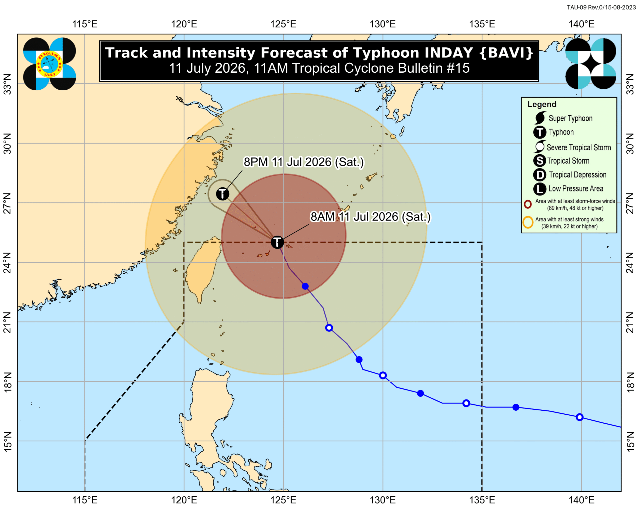
Typhoon Inday (Bavi) left the Philippine Area of Responsibility at 8:20 a.m. on July 11, 2026, but its outer bands continued to bring strong winds while enhancing the southwest monsoon. [4] As of 10 a.m. that day, the storm was located 590 km north-northeast of Itbayat, Batanes, moving north-northwest at 20 km/h with maximum sustained winds of 140 km/h and gusts up to 170 km/h. [4]
Typhoon Inday Exits Philippine Waters
Typhoon Inday exited the Philippine Area of Responsibility at 8:20 a.m. on July 11, 2026. [4] At 10 a.m., the system stood 590 km north-northeast of Itbayat, Batanes, and was moving north-northwest at 20 km/h. [4] The typhoon carried maximum sustained winds of 140 km/h and gustiness reaching 170 km/h according to the 11 a.m. PAGASA bulletin. [4] Inside the PAR, Inday reached peak intensity as a super typhoon with maximum sustained winds of 195 km/h. [4] The storm did not make landfall in the Philippines, yet its size and intensity still affected parts of Luzon. [4] Inday became the ninth tropical cyclone to enter or form within the PAR in 2026 and the second for July. [4] After leaving the PAR, the system was forecast to head into the East China Sea and possibly make landfall along the eastern coast of mainland China on Saturday night or Sunday morning, July 12. [4] PAGASA stated that Inday was expected to remain a typhoon for the next 12 hours before possibly weakening into a severe tropical storm over mainland China. [4]
Monsoon Enhancement Brings Heavy Rains
The enhanced southwest monsoon and the outer bands of Typhoon Inday were forecast to deliver significant rainfall across multiple regions over the following three days. [4] From Saturday noon, July 11, to Sunday noon, July 12, heavy to intense rain totaling 100-200 mm was expected in Zambales, Bataan, and Occidental Mindoro, while moderate to heavy rain of 50-100 mm was anticipated in La Union, Pangasinan, Benguet, Tarlac, Pampanga, Bulacan, Metro Manila, Rizal, Cavite, Laguna, Batangas, Oriental Mindoro, Romblon, Marinduque, Palawan, Antique, Aklan, Capiz, Iloilo, Guimaras, and Negros Occidental. [4] From Sunday noon, July 12, to Monday noon, July 13, the same heavy to intense amounts were projected again for Zambales, Bataan, and Occidental Mindoro, with moderate to heavy rain extending to Ilocos Norte, Ilocos Sur, Abra, La Union, Pangasinan, Benguet, Tarlac, Pampanga, Bulacan, Metro Manila, Rizal, Cavite, Batangas, Oriental Mindoro, Romblon, Palawan, Antique, Aklan, and Negros Occidental. [4] From Monday noon, July 13, to Tuesday noon, July 14, heavy to intense rain of 100-200 mm was limited to Zambales, while moderate to heavy rain of 50-100 mm was forecast for Ilocos Norte, Ilocos Sur, Abra, La Union, Pangasinan, Benguet, Tarlac, Bataan, Pampanga, and Occidental Mindoro. [4] PAGASA warned that affected areas should remain alert for floods and landslides due to the persistent monsoon rains. [4] Inday was no longer expected to trigger significant rainfall in Batanes after exiting the PAR, although the province stayed under Signal No. 1 as of 11 a.m. on July 11 because of strong winds. [4] Signal No. 2 had been the highest tropical cyclone wind signal raised during the storm’s passage. [4]
Strong Winds and Hazardous Seas Persist
The outer bands of Typhoon Inday continued to produce strong to gale-force gusts across wide areas even after the system left the PAR. [4] On Saturday, July 11, gusts were expected in most of the country. [4] On Sunday, July 12, the gusts were forecast to affect most of Luzon, most of Visayas, Zamboanga del Norte, Misamis Occidental, Lanao del Norte, Camiguin, and Davao Oriental. [4] On Monday, July 13, the gusts were projected to impact most of Luzon, Western Visayas, and Negros Occidental. [4] Coastal warnings remained in effect on July 11, with seas reaching up to 7 meters high on the northern seaboard of Batanes and up to 6 meters on the remaining seaboards of Batanes, making travel risky for all vessels. [4] Waves up to 5 meters high were forecast on the northern seaboard of Babuyan Islands, while waves up to 4.5 meters were expected on the northern seaboard of mainland Cagayan and the remaining seaboards of Babuyan Islands. [4] Rough seas with waves up to 4 meters high were warned for the seaboard of Isabela, the northern seaboard of Ilocos Norte, and the remaining seaboard of mainland Cagayan, while waves up to 3.5 meters were forecast for the seaboard of northern Aurora and the northern and eastern seaboards of Catanduanes. [4] Additional rough-sea warnings included waves up to 3 meters high along multiple other seaboards, and moderate to rough seas with waves up to 2.5 meters or 2 meters were noted in further zones. [4]
Typhoon Impacts Travel in East Asia
Thai Airways International cancelled additional flights between Bangkok and Shanghai and Bangkok and Taipei because of Typhoon Bavi. [5] The cancelled Saturday flights included TG664 from Bangkok to Shanghai departing at 10:45 a.m., TG665 from Shanghai to Bangkok departing at 5:25 p.m., and TG636 from Bangkok to Taipei departing at 5:15 a.m. [5] Flight TG637 from Taipei to Bangkok scheduled for 7:55 a.m. on Sunday was also cancelled. [5] In Taiwan, the government evacuated more than 14,000 people, mainly from mountainous areas in the north and east. [5] A total of 917 international flights and all 274 domestic flights were cancelled. [5] Almost all cities and counties across Taiwan declared a typhoon holiday for Saturday, closing offices and schools that might otherwise have been open on the weekend. [5] The main north-south high-speed rail line remained open but operated with reduced service. [5] Blustery wind and rain continued in the capital Taipei. [5]
What to watch next: Inday is expected to remain a typhoon for the next 12 hours before possibly weakening into a severe tropical storm over mainland China after a potential landfall on the eastern coast on Saturday night or Sunday morning, July 12. [4]