
Typhoon Bavi Nears Taiwan With Heavy Rain Forecast for Friday
Typhoon Bavi is forecast to bring heavy rain and potential flooding to Taiwan starting Friday as it passes north of the island, while severe thunderstorms and flash flooding are impacting parts of the eastern United States.
Typhoon Bavi Approaches Taiwan
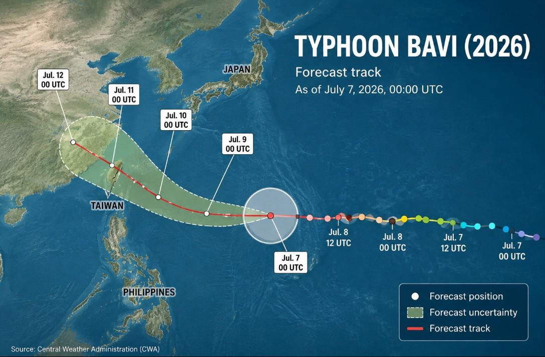
As Typhoon Bavi approaches Taiwan from the southeast, a sea warning is expected to be issued on Thursday, followed by a land warning on either Thursday evening or Friday morning, the Central Weather Administration (CWA) said today. [1] With a relatively wide radius of 350km, the typhoon is expected to affect a wide swathe of the country as it passes by to the north. [1] As of 8am this morning, the center of the typhoon was 2,100km east-southeast of Oluanpi (鵝鑾鼻), Taiwan's southernmost point, moving west at a speed of 29kph, the CWA said. [1] Maximum sustained winds near its center reached 60 meters per second, with a gale-force wind radius of 350km and a storm-force wind radius of 150km, it added. [1] The typhoon is weakening as it approaches Taiwan, though is still expected to arrive with an intensity ranging from between the upper end of a moderate typhoon to the lower end of a strong typhoon, CWA forecaster Lee Meng-hsuan (李孟軒) said. [1]
Forecasted Heavy Rain and Impacts
The projected path of Typhoon Bavi is pictured as of 8am today. [1] The typhoon is expected to gradually move away on Sunday, although brief thunderstorms would still be likely across the country, it added. [1] Torrential rain is forecast in mountainous regions north of Taichung on Friday and Saturday, while heavy rain is also expected across central and northern Taiwan, the northeast, Nantou County and mountainous areas of Hualien County, the CWA said. [1] The heaviest rain is expected on Friday and Saturday, when its path tracks closest to Taiwan, the weather agency said. [1] The storm is weakening but expected to arrive with intensity between upper moderate and lower strong typhoon levels, gradually moving away on Sunday with possible brief thunderstorms. [1]
Flash Flooding Hits Northern Virginia
Flash Flood Warning: Fauquier, VA. [5] The National Weather Service in Sterling Virginia has issued a Flash Flood Warning for Central Fauquier County in northern Virginia until 4:15am EDT. [5] At 1:11am EDT, local law enforcement reported flash flooding across the warned area, especially along US-17 and adjacent roadways along Cedar Run. [5] Between 4 and 6 inches of rain have fallen. [5] Additional rainfall amounts of 0.5 to 1.5 inches are possible in the warned area. [5] The hazard includes life threatening flash flooding from heavy rain. [5]
Severe Thunderstorms Strike Mississippi
Severe Thunderstorm Warning: Hinds, MS. [3] The National Weather Service in Jackson has issued a Severe Thunderstorm Warning for central Rankin County in central Mississippi and central Hinds County in central Mississippi until 1:15am CDT. [3] At 12:21am CDT, a severe thunderstorm was located near Byram, moving east at 25 mph. [3] Hazards include 60 mph wind gusts and quarter size hail, according to radar indicated sources. [3] Impacts include hail damage to vehicles expected and wind damage to roofs, siding, and trees. [3]
Flooding Continues in Connecticut
Flood Warning: Fairfield, CT. [4] Flooding caused by excessive rainfall continues in a portion of southern Connecticut, including Fairfield County, until 3:30am EDT. [4] Impacts include flooding of rivers, creeks, streams, and other low-lying and flood-prone locations imminent or occurring. [4] At 1:13am EDT, Doppler radar indicated heavy rain due to thunderstorms. [4] Flooding is ongoing or expected to begin shortly in the warned area, with between 3 and 5 inches of rain having fallen. [4]
Flood Waters Receding in North Carolina
Flash Flood Warning: Durham, NC. [2] Local stream gauges show creeks and streams crested and flood waters beginning to recede. [2] Additional flooding is no longer expected to pose a threat. [2] Residents should continue to heed remaining road closures. [2]
What to watch next: The typhoon is expected to gradually move away on Sunday with brief thunderstorms still likely, while the Virginia flash flood warning remains in effect until 4:15am EDT, the Mississippi severe thunderstorm warning until 1:15am CDT, and the Connecticut flood warning until 3:30am EDT.