
Taiwan May Issue Sea Warning for Typhoon Dolphin by Friday Afternoon
Taiwan Prepares for Typhoon Dolphin
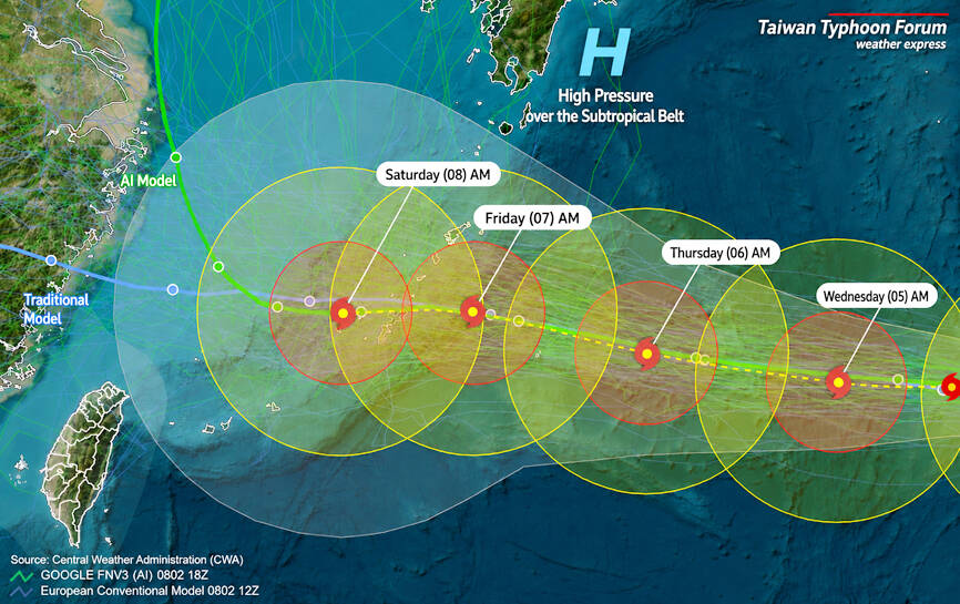
Taiwan could issue a sea warning for Typhoon Dolphin as early as Friday afternoon if the storm maintains its current westward track, the Central Weather Administration said yesterday. [1] As of 2pm yesterday the center of the typhoon was about 2,590km east of Taipei and moving west at 21kph, potentially bringing hazardous conditions to waters surrounding Taiwan by Saturday. [1] Dolphin is expected to reach waters south of the Ryukyu Islands around Saturday, but its track beyond that remains highly uncertain, CWA forecaster Lin Ping-yu said. [1] The typhoon could either continue moving westward or veer northward, Lin said. [1] A westward track would bring greater impacts to Taiwan from its outer circulation, while an earlier northward turn would have less effects. [1] Although ocean temperatures along Dolphin’s westward path are relatively low, they remain sufficient to sustain the storm’s current intensity, so it is unlikely to weaken rapidly, he said. [1] Dolphin is expected to remain a moderate typhoon or tropical storm while retaining a relatively large circumference, he added. [1] A Friday afternoon sea warning indicating that hazardous typhoon conditions are expected in waters surrounding Taiwan within 24 hours cannot be ruled out if the storm continues west, Lin said. [1] If Dolphin turns north, a sea warning might still be issued if it changes direction too late and if the storm does not shrink significantly, he added. [1] The projected path of Typhoon Dolphin is pictured yesterday. [1]
Expected Impacts on Taiwan
From today through Thursday, northeasterly winds are expected to bring isolated showers to northeastern Taiwan and mountainous areas around Greater Taipei, with localized heavy rain possible in mountain regions tomorrow and on Thursday afternoon. [1] As the typhoon approaches, winds are expected to shift to northerly or northwesterly from Friday through Sunday, with foehn winds possible in Yilan on Thursday, and in Hualien and Taitung on Friday and Saturday. [1] Rainfall is expected to become more widespread in northern Taiwan and mountainous areas in the south over the weekend, Lin said. [1] The typhoon’s track remains uncertain and could either continue westward, bringing greater impacts to Taiwan from its outer circulation, or veer northward with lesser effects. [1] Ocean temperatures are sufficient to sustain the storm’s intensity, so Dolphin is expected to remain a moderate typhoon or tropical storm with a large circumference and is unlikely to weaken rapidly. [1] A sea warning for typhoon conditions in waters surrounding Taiwan within 24 hours cannot be ruled out if the storm continues west. [1] If the storm turns north a sea warning might still be issued if it changes direction too late and does not shrink significantly. [1]

Taiwan monitors Typhoon Dolphin as it tracks west toward the island. — Source: bbc
Critical Fire Weather in North Dakota
A Red Flag Warning remains in effect until 9 PM CDT /8 PM MDT/ this evening for southwest North Dakota, and from 11 AM MDT /NOON CDT/ this morning to 8 PM MDT /9 PM CDT/ this evening for parts of south-central North Dakota. [2] [3] Critical fire weather conditions are expected across southwest and parts of south central North Dakota today. [2] [3] Northerly winds will increase to around 25 to 30 mph this afternoon, with gusts as high as 40 mph. [2] [3] Relative humidity could fall as low as 25 percent this afternoon. [2] [3] The Red Flag Warning covers southwest and parts of south-central North Dakota with northerly winds of 25-30 mph, gusts to 40 mph, and relative humidity as low as 25 percent. [2] [3]
Flash Flooding Strikes Northeast U.S.
A Flash Flood Warning is in effect for west central Bristol County in southeastern Massachusetts, northwestern Bristol County in Rhode Island, Kent County in Rhode Island, Providence County in Rhode Island, and northeastern Washington County in Rhode Island until 145 PM EDT. [4] At 1123 AM EDT, Doppler radar indicated thunderstorms producing heavy rain across the warned area. [4] Between 1 and 3 inches of rain have fallen. [4] A Flash Flood Warning is also in effect for Burlington County, New Jersey. [5] At 1103 AM EDT, a combination of NJDOT, automated rain gauges, and media reports indicated flash flooding is ongoing with extensive flooding being reported in the Highlands area of NJ and portions of both North and South Brunswick have reported road closures. [5] Doppler radar indicated thunderstorms producing heavy rain across portions of the warned area. [5] Between 1 and 4 inches of rain have fallen already with additional rainfall of up to 2 inches possible. [5] Flash Flood Warnings were issued for parts of Massachusetts and Rhode Island after thunderstorms dropped 1-3 inches of rain, and for Burlington County, New Jersey, where 1-4 inches have already fallen with up to 2 inches more possible and ongoing road closures reported. [4] [5]
Broader Severe Weather Context
Taiwan’s Central Weather Administration warned that a sea warning for Typhoon Dolphin could be issued as early as Friday afternoon if the storm continues its westward track. [1] Separate U.S. alerts addressed critical fire weather in North Dakota and flash flooding in the Northeast. [2] [3] [4] [5] As of 2pm yesterday Typhoon Dolphin was located 2,590km east of Taipei, moving west at 21kph and expected to reach waters south of the Ryukyu Islands around Saturday. [1] Dolphin’s track remains uncertain and could either continue westward, bringing greater impacts to Taiwan from its outer circulation, or veer northward with lesser effects. [1] Ocean temperatures are sufficient to sustain the storm’s intensity, so Dolphin is expected to remain a moderate typhoon or tropical storm with a large circumference and is unlikely to weaken rapidly. [1] A Red Flag Warning for critical fire weather is in effect for southwest and parts of south-central North Dakota with northerly winds of 25-30 mph, gusts to 40 mph, and relative humidity as low as 25 percent. [2] [3] Flash Flood Warnings were issued for parts of Massachusetts and Rhode Island after thunderstorms dropped 1-3 inches of rain, and for Burlington County, New Jersey, where 1-4 inches have already fallen with up to 2 inches more possible and ongoing road closures reported. [4] [5] These alerts reflect concurrent severe weather events across Asia and North America.
What to watch next: Officials will continue monitoring whether Typhoon Dolphin maintains its westward track toward waters south of the Ryukyu Islands around Saturday or veers northward, which could affect the timing of any sea warning.