
Taiwan Issues Sea Warning as Super Typhoon Bavi Approaches
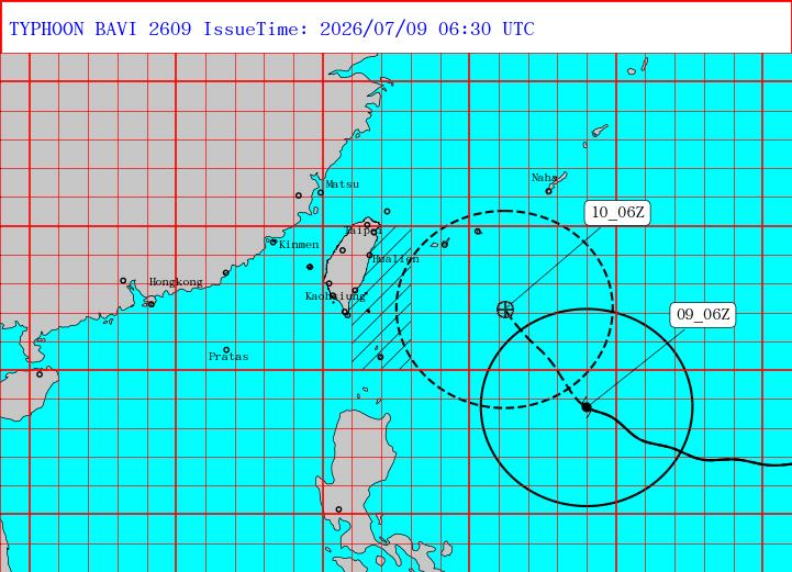
Taiwan’s Central Weather Administration issued a sea warning for waters in the Bashi Channel and southeast and northeast of Taiwan, including areas around Orchid Island and Green Island, while Thai Airways alerted passengers to monitor flights to and from Taiwan from Thursday through Sunday. [1] Super Typhoon Bavi was located at 2pm with its eye 920km east-southeast of Taiwan’s southernmost point Oluanpi and was moving north-northwest at 20-23kph. [1] The storm carried maximum sustained winds of 51m/s, equivalent to Beaufort force 16, and a central pressure of 925hPa. [1] Bavi is forecast to skirt northern Taiwan before landfall in China’s eastern Fujian province on Saturday evening. [3] It is expected to be the largest storm by size to hit Taiwan since 1987. [3] Separate severe thunderstorm warnings were issued by the US National Weather Service for parts of eastern Kansas. [2]
Taiwan Issues Sea Warning for Approaching Typhoon Bavi
Taiwan’s Central Weather Administration at 2:30pm today issued a sea warning for Typhoon Bavi. [1] The storm posed a threat to the Bashi Channel as well as waters southeast and northeast of Taiwan. [1] Vessels operating in those waters, including areas around Orchid Island and Green Island, should exercise heightened caution. [1] At 2pm today the eye of Bavi was about 920km east-southeast of Oluanpi, Taiwan’s southernmost point. [1] The typhoon was moving north-northwest at a speed of 20kph to 23kph. [1] The storm was expected to turn northwest. [1] Bavi had a central atmospheric pressure of 925 hectopascals and maximum sustained winds of 51 meters per second near its center, equivalent to a Beaufort scale force of 16. [1] The typhoon's radius of 15-meter-per-second winds averaged 380km, while its radius of 25-meter-per-second winds averaged 180km. [1] The projected path of Typhoon Bavi was shown as of 2:30pm today. [1]
Bavi Forecast to Skirt Taiwan and Strike China
Bavi is forecast to skirt northern Taiwan before making landfall in China’s eastern Fujian province on Saturday evening. [3] It is expected to be the largest storm by size to hit Taiwan since 1987. [3] Storms of this size have been fairly rare in recent years. [3] At 2pm the eye of Bavi was about 920km east-southeast of Oluanpi. [1] The typhoon was moving north-northwest at 20kph to 23kph with a central pressure of 925 hectopascals. [1] Maximum sustained winds reached 51 meters per second near the center. [1] The Central Weather Administration noted the radius of 15-meter-per-second winds averaged 380km. [1]
Airlines Warn of Flight Disruptions to Taiwan
Thai Airways International has advised passengers travelling from and to Taiwan to monitor their flight schedules between Thursday and Sunday. [3] Super typhoon Bavi is moving toward the island. [3] Adverse weather conditions may result in flight delays, schedule changes or flight cancellations to ensure travel safety. [3] Thai Airways operates daily flights from and to Taiwan Taoyuan International Airport in Taipei. [3] Passengers can check flight status on the THAI Mobile Application, thaiairways.com Thailand, the THAI Contact Center at +66(0) 2356-1111, or the overseas THAI Contact Center at (+88) 62-7753-7973, 24 hours a day. [3] Bavi is forecast to skirt northern Taiwan before making landfall in eastern Fujian province on Saturday evening. [3]
Severe Thunderstorms Strike Eastern Kansas Overnight
The National Weather Service in Topeka issued a severe thunderstorm warning for northwestern Franklin County, southern Jefferson County, southeastern Shawnee County, Douglas County and Osage County in east central Kansas. [2] The warning was in effect until 315 AM CDT. [2] At 232 AM CDT severe thunderstorms were located along a line extending from near Tecumseh to 3 miles south of Burlingame, moving southeast. [2] A separate severe thunderstorm warning covered Lyon County. [4] At 221 AM CDT a severe thunderstorm was located near Carbondale, moving southeast at 40 mph. [4] The hazard included 60 mph wind gusts. [4] Radar indicated the source of the winds. [4] Impacts expected included damage to roofs, siding and trees. [4] Locations impacted included southern Topeka, Carbondale, Richland, Auburn, Overbrook, Burlingame, Scranton and Harveyville. [4] The warning also covered Kansas Turnpike between mile markers 147 and 174. [4]
Europe Records Thousands of Heat-Related Deaths
Rundt 5100 personer have died in Germany as a result of heat-related causes in recent months according to health authorities in the country. [5] The period ran from 6 April to 28 June. [5] The state Robert Koch Institute provided the estimate. [5] June became the month when heat waves led to temperature records in one European country after another. [5] It ended with the warmest June month ever registered in Western Europe. [5] French health authorities registered an increase of almost 30 percent in the number of deaths during the heat wave in the last week of June. [5] In Belgium the increase was almost 40 percent. [5] During a powerful heat wave in 2003 around 15,000 people died in France alone, many of them elderly who died in nursing homes. [5] Researchers have said the heat wave was the most intense ever registered in Europe. [5]
What to watch next: Passengers should continue monitoring flight status through Sunday as Bavi approaches Taiwan, while the storm is projected to reach eastern Fujian province on Saturday evening.