
Severe Thunderstorms With 70 mph Winds Hit Colorado, Kentucky and Missouri
Severe thunderstorms with 70 mph wind gusts prompted warnings across parts of Colorado, Kentucky and Missouri on Thursday evening while Typhoon Inday weakened but continued to drive heavy monsoon rains across the Philippines.
U.S. Severe Thunderstorm Warnings Issued
A Severe Thunderstorm Warning was issued for Bent County, Colorado, at 6:22 p.m. MDT for storms moving southeast at 30 mph with 70 mph wind gusts and nickel-size hail. [1] The warning threatened tree damage, mobile homes, roofs and outbuildings in communities including Wiley, Hasty and McClave. [1] Radar indicated the storms were located along a line extending from near Neegronda Reservoir to 8 miles south of McClave to 15 miles south of John Martin Reservoir. [1] Locations impacted include Wiley, Hasty, McClave, Neegronda Reservoir, John Martin Reservoir, and Caddoa. [1]
Severe Thunderstorm Warnings were issued for Ballard County, Kentucky, at 7:23 p.m. CDT and Mississippi County, Missouri, at 7:21 p.m. CDT for storms with 70 mph wind gusts moving east. [3] [4] In Kentucky the storms were located along a line extending from Cairo to 6 miles northwest of Clinton and moved east at 40 mph. [3] Locations impacted include Wickliffe, Wyatt, Arlington, Columbus, and Wilson City. [3] In Missouri the storm was located near Wyatt, or 8 miles southeast of Charleston, and moved east at 25 mph. [4] The Missouri storm remained over mainly rural areas of east central Mississippi County. [4] Both warnings expected considerable tree damage and impacts to mobile homes, roofs and outbuildings. [3] [4]
Flash Flood Warning Lifted in Delaware
A Flash Flood Warning for New Castle, Delaware, was canceled after flood waters receded and heavy rain ended. [2] Flooding is no longer expected to pose a threat, though residents should continue to heed remaining road closures. [2] Flood Watches remained in effect until midnight EDT for southeast Pennsylvania, northern Delaware and southern New Jersey. [2]
Typhoon Inday Weakens Near Philippines
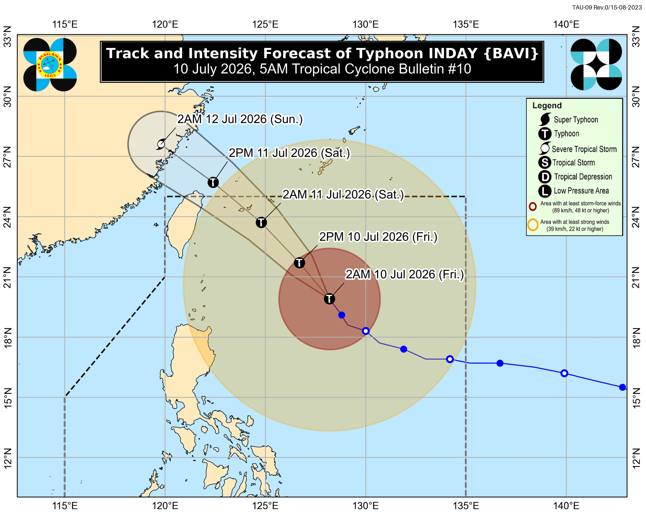
Typhoon Inday (Bavi) weakened to maximum sustained winds of 150 km/h with gusts to 185 km/h while located 620 km east of Basco, Batanes. [5] The storm moved northwest at 20 km/h. [5] It is forecast to pass closest to extreme northern Luzon late Friday night into Saturday morning. [5] As of 4 am on Friday the typhoon was already 620 kilometers east of Basco, Batanes. [5] Batanes is seeing moderate to heavy rain of 50-100 millimeters due to Inday on Friday. [5] The typhoon may also trigger rain with gusty winds in the Cordillera Administrative Region, Ilocos Norte, Cagayan, and Isabela, as well as scattered rain and thunderstorms in the rest of the Ilocos Region, the rest of Cagayan Valley, Bicol, Central Luzon except Zambales and Bataan, and Quezon. [5]
Monsoon Rains Expected Across Philippines
The enhanced southwest monsoon triggered by Inday is forecast to bring heavy to intense rainfall of 100-200 mm to Occidental Mindoro, Antique, Zambales and Bataan on Friday through Sunday. [5] Moderate to heavy rains of 50-100 mm are expected across Metro Manila, other Luzon provinces, the Visayas and parts of Mindanao. [5] On Friday heavy to intense rain of 100-200 mm is forecast for Occidental Mindoro and Antique while moderate to heavy rain of 50-100 mm is forecast for Zambales, Bataan, Metro Manila, Rizal, Cavite, Laguna, Batangas, Oriental Mindoro, Romblon, Palawan, Aklan, Capiz, Iloilo, Guimaras, Negros Occidental, Negros Oriental, Zamboanga del Sur, Lanao del Norte, and Lanao del Sur. [5] On Saturday heavy to intense rain of 100-200 mm is forecast for Occidental Mindoro, Zambales and Bataan while moderate to heavy rain of 50-100 mm is forecast for La Union, Pangasinan, Benguet, Tarlac, Pampanga, Bulacan, Metro Manila, Rizal, Cavite, Laguna, Batangas, Oriental Mindoro, Romblon, Palawan, Antique, Aklan, Capiz, Iloilo, Guimaras, Negros Occidental. [5] On Sunday heavy to intense rain of 100-200 mm is forecast for Occidental Mindoro, Zambales and Bataan while moderate to heavy rain of 50-100 mm is forecast for La Union, Pangasinan, Benguet, Tarlac, Pampanga, Bulacan, Metro Manila, Rizal, Cavite, Laguna, Batangas, Oriental Mindoro, Romblon, Palawan and Antique. [5] Floods and landslides are likely. [5]
Tropical Cyclone Wind Signals and Sea Conditions
Areas under tropical cyclone wind signals as of 5 am on Friday include Signal No. 2 for gale-force winds of 62 to 88 km/h with minor to moderate threat to life and property in Batanes, eastern part of Babuyan Islands including Babuyan Island, Didicas Island and Camiguin Island, and northeastern part of mainland Cagayan including Santa Ana. [5] Signal No. 1 covers strong winds of 39 to 61 km/h with minimal to minor threat to life and property in the rest of Babuyan Islands, rest of mainland Cagayan, Isabela, Apayao, northern part of Abra including Tineg, Lagayan, Danglas, San Juan, Lagangilang, Licuan-Baay, Malibcong, Lacub, Daguioman, Dolores, La Paz, Kalinga, eastern part of Mountain Province including Natonin and Paracelis, eastern part of Ifugao including Aguinaldo and Alfonso Lista, and Ilocos Norte. [5] The enhanced southwest monsoon and the periphery or outer bands of the typhoon are also bringing strong to gale-force gusts to most of the country on Friday and Saturday and to most of Luzon, most of Visayas, Zamboanga del Norte, Misamis Occidental, Lanao del Norte, Camiguin and Davao Oriental on Sunday. [5]
On Friday conditions in certain seaboards remain dangerous due to Inday and the enhanced southwest monsoon. Up to very rough seas with waves up to 7 meters high affect the northern and eastern seaboards of Batanes. [5] Seaboards of Babuyan Islands, northeastern seaboard of mainland Cagayan, and remaining seaboards of Batanes have waves up to 6 meters high. [5] Remaining seaboards of mainland Cagayan and seaboard of Isabela have waves up to 5 meters high. [5] Seaboards of Aurora and Camarines Norte, northern and eastern seaboards of Polillo Islands and Catanduanes, and northern seaboards of Ilocos Norte and Camarines Sur have waves up to 4.5 meters high. [5] Up to rough seas with waves up to 4 meters high affect northern seaboards of mainland Quezon, seaboards of Northern Samar, and eastern seaboards of Albay, Sorsogon, and Eastern Samar. [5] Eastern seaboards of Dinagat Islands, Bucas Grande-Siargao Islands, and Surigao del Sur, eastern and southern seaboards of Davao Oriental, remaining seaboards of Catanduanes and Camarines Sur, and western seaboard of Ilocos Norte have waves up to 3.5 meters high. [5] Seaboards of Marinduque, Romblon, Masbate, Caluya Islands, and Kalayaan Islands, western seaboards of Bataan, Occidental Mindoro including Lubang Islands, and Calamian Islands, southern seaboard of Quezon, and southern and eastern seaboards of Oriental Mindoro have waves up to 3 meters high. [5] Up to moderate to rough seas with waves up to 2.5 meters high affect seaboards of Cuyo Islands, Cagayancillo Islands, Antique, Ilocos Sur, Pangasinan, and Zambales, western seaboards of Cavite, Batangas, and Negros Occidental, southern seaboards of Iloilo and Guimaras, and remaining seaboards of Camarines Sur, Albay, Sorsogon, and Northern Samar. [5] Remaining seaboards of Visayas, Southern Luzon, Surigao del Norte, and Dinagat Islands, seaboards of Camiguin, Misamis Oriental, and Zamboanga del Norte, and southern seaboards of Basilan, Sulu, Tawi-Tawi, and Davao Occidental have waves up to 2 meters high. [5]
Storm's Projected Path Beyond Philippines
After passing close to extreme Northern Luzon, Inday is projected to move toward Japan’s southern islands, and make landfall in or pass close to Taiwan’s northern coast. [5] The typhoon may exit the Philippine Area of Responsibility on Saturday morning or afternoon, followed by another potential landfall in China by Saturday evening or early Sunday morning, July 12. [5] It could weaken into a severe tropical storm over China. [5]
What to watch next: Inday is expected to be closest to extreme Northern Luzon between Friday night and Saturday morning before exiting the Philippine Area of Responsibility on Saturday morning or afternoon and potentially making landfall in China by Saturday evening or early Sunday morning.