Severe Thunderstorms Trigger Flood Warnings in Northeast US as Estonia Recovers from Heavy Rain
Severe thunderstorms triggered flash flood and severe thunderstorm warnings across parts of the northeastern United States early Sunday while a major storm that brought heavy rain, strong winds and power outages subsided in Estonia and a heat wave intensified across Greece.
Active Warnings in the Northeastern United States
A severe thunderstorm warning was issued for western Cuyahoga County in northeastern Ohio and northeastern Lorain County until 4 a.m. EDT with quarter-size hail possible. [1] At 3:34 a.m. EDT, a severe thunderstorm was located over Elyria, moving east at 20 mph. [1] The hazard included quarter size hail according to radar indicated sources. [1] Minor damage to vehicles is possible from the storm. [1] Locations impacted include Elyria, North Ridgeville, Grafton, North Olmsted and Avo. [1]
A flash flood warning covered northeastern New Castle County in Delaware and southeastern Delaware County in Pennsylvania until 7:45 a.m. EDT after up to 1 inch of rain had already fallen with rates of 1-2 inches per hour expected. [2] At 3:32 a.m. EDT, Doppler radar indicated thunderstorms producing heavy rain across the warned area. [2] Up to 1 inch of rain has fallen with the expected rainfall rate of 1 to 2 inches in 1 hour. [2] Additional rainfall amounts up to 1 inch are possible in the warned area. [2]
Storm Subsides in Estonia After Heavy Rain and Winds
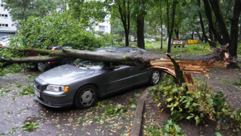
Estonia's Level 2 storm warning was downgraded to Level 1 with 50-70 mm of rain in 24 hours and locally up to 90 mm, downing trees, causing power outages for around 2,600 households as of Sunday morning, and prompting flood prevention advice in Tallinn. [3] The Level 2 storm which hit Estonia on Saturday has started to subside, though strong winds and rain are still forecast for Sunday. [3] Heavy rain with some locations receiving the average monthly rainfall in the space of 24 hours and strong winds swept across Estonia over the weekend, bringing down trees, causing power outages and disrupting ferry services. [3] The weather warning has been downgraded to Level 1 in western and southern Estonia as of Sunday morning. [3] Eastern Estonia counties including Ida-Viru, Lääne-Viru, Järva, Jõgeva and Tartu are now not subject to the warning. [3] Heavy rain is to continue over Estonia on Sunday morning, with 24-hour totals of 50–70 millimeters and up to 90 millimeters in some areas. [3] These higher figures are roughly the same as the overall average rainfall for August, usually the wettest month, in Estonia. [3] Wind gusts reached as high as 30 meters per second on Saturday. [3] The Rescue Board has been notified of fallen trees on roads and power lines. [3] On Saturday evening, 3,410 households were without power according to Elektrilevi. [3] As of 9 a.m. Sunday, that figure had fallen to around 2,600, though around half the outages were in southeastern Estonia. [3] Heavy rainfall of 50–100 millimeters overnight threatened Tallinn's sewage and drainage system. [3] Tallinna Vesi issued flood prevention advice, including clearing gutters, avoiding parking in flood-prone areas, and reducing water use during the rain. [3] Urmas Kütt, head of pipeline operations at Tallinna Vesi, noted that during and immediately after heavy rain, the public should avoid using large amounts of water to avoid placing additional strain on the wastewater system. [3] Stormwater should not be directed into the sewer network to avoid overloading the system. [3] People should avoid flooded basements and manholes due to electrocution and other hazards. [3] Ferry services were subject to cancellation during the storm but are back online as of Sunday morning. [3] The 8.30 a.m. sailing from Rohuküla to Heltermaa went ahead, and the 10 a.m. service in the other direction is also on schedule. [3] No changes to the Virtsu to Kuivastu route timetable are currently expected. [3]
Greece Prepares for Extreme Heat Wave
Temperatures in Greece are forecast to reach 38-40 degrees Celsius on Sunday with high humidity, remaining elevated through mid-week in western areas before easing. [4] A heat wave is expected to push temperatures toward 40 degrees Celsius in parts of Greece, with above-normal temperatures forecast to persist through the middle of next week. [4] Temperatures will reach 38 to 39 degrees across much of mainland Greece on Sunday, with some areas reaching 40 degrees. [4] Island temperatures will range from 35 to 37 degrees. [4] High humidity is expected to make conditions feel more oppressive. [4] Northerly winds will strengthen from Monday, reaching 6 to 7 on the Beaufort scale in parts of the Aegean Sea. [4] The stronger winds will bring a gradual decline in temperatures in northern and eastern Greece. [4] Western Greece and the Peloponnese will remain particularly hot Monday and Tuesday, as northerly winds descend from higher elevations and warm the air. [4] Temperatures could reach 40 degrees Celsius in some areas. [4] Mostly clear conditions are expected, although localized rain and showers could develop in mountainous areas during the afternoon. [4] Isolated thunderstorms are possible, particularly in northern Greece. [4] Temperatures are expected to remain largely unchanged Tuesday and Wednesday before beginning to ease Thursday as northerly winds strengthen. [4]
Critical Fire Weather Alert in Washington State
A Red Flag Warning for critical fire weather was issued for the foothills of northeast Washington and eastern Columbia Basin due to thunderstorms, gusty winds up to 30 mph and low humidity from a cold front. [5] A cold front will move through the region Saturday into Sunday, bringing a risk for thunderstorms and strong west to southwest winds. [5] This will lead to critical fire weather conditions across the region. [5] Affected areas include the Foothills of Northeast Washington and Eastern Columbia Basin, Palouse and Spokane Area. [5] Winds are southwest 10 to 20 mph with gusts up to 30 mph. [5] Relative humidities are 17 t. [5]
Regional Impacts in the Baltics
The storm also hit Latvia and Lithuania. [3] Latvia's weather service issued a storm warning, outdoor events were canceled and roads were flooded in several places. [3] In Riga, water accumulated beneath viaducts, disrupting traffic. [3] According to Lithuanian media, at least one person was killed after being struck by a falling tree and over 150,000 households were left without power. [3]
What to watch next: Temperatures could reach 40 degrees Celsius in some areas of western Greece and the Peloponnese on Monday and Tuesday as northerly winds descend from higher elevations and warm the air while the Red Flag Warning covers the foothills of northeast Washington and eastern Columbia Basin through Sunday with gusts up to 30 mph.