
Severe Thunderstorms With 60 mph Winds Sweep Across Northeastern Minnesota
Severe thunderstorms with 60 mph winds and heavy rains have triggered flash flooding, road collapses and fire weather alerts across parts of the United States and Finland in the past 24 hours.
Severe Thunderstorms Strike Northeastern Minnesota
A line of severe thunderstorms moving east at 50 mph produced 60 mph wind gusts and penny-size hail across Cook County and northeastern Lake County in Minnesota early Wednesday, threatening damage to roofs, siding and trees in communities including Grand Marais and the Boundary Waters Canoe Area Wilderness. [3] At 542 AM CDT, severe thunderstorms were located along a line extending from 17 miles east of Gunflint Lake to Boundary Waters Canoe Area Wilderness to 8 miles northwest of Lutsen, moving east at 50 mph. [3] The National Weather Service in Duluth MN has issued a Severe Thunderstorm Warning for Cook County in northeastern Minnesota and northeastern Lake County in northeastern Minnesota until 615 AM CDT. [4] At 515 AM CDT, severe thunderstorms were located along a line extending from 6 miles northeast of Saganaga Lake to Boundary Waters Canoe Area Wilderness to 7 miles southeast of Boundary Waters Canoe Area Wilderness Near Trout Lake, moving east at 50 mph. [4] Hazard conditions include 60 mph wind gusts and penny size hail according to radar indicated sources. [3] Impacts are expected to include damage to roofs, siding, and trees in locations such as Lutsen, eastern Boundary Waters Canoe Area Wilderness, Eagle Mountain, Cascade River State Park, Grand Marais, and Judge Magney State Park. [3] The line of severe thunderstorms moving east at 50 mph produced 60 mph wind gusts and penny-size hail across Cook County and northeastern Lake County in Minnesota early Wednesday. [4] These conditions threaten damage to roofs, siding and trees in communities including Grand Marais and the Boundary Waters Canoe Area Wilderness. [3] The severe thunderstorm warnings cover the period until 615 AM CDT with storms advancing at 50 mph. [4] Radar sources confirm the hazards of 60 mph wind gusts and penny size hail. [3] Communities at risk include Lutsen, eastern Boundary Waters Canoe Area Wilderness, Eagle Mountain, Cascade River State Park, Grand Marais, and Judge Magney State Park. [3] The storms extended from areas near Saganaga Lake through the Boundary Waters Canoe Area Wilderness near Trout Lake. [4]
Critical Fire Weather in South-Central North Dakota
Red Flag Warnings remain in effect until 9 p.m. CDT Wednesday for Morton, Grant, Sioux and Emmons counties in south-central North Dakota, where northwest winds of 25 mph with gusts to 40 mph and relative humidity dropping to 20 percent will create critical fire weather conditions. [1] The Red Flag Warning remains in effect from noon CDT today to 9 PM CDT this evening due to wind and low relative humidity for Morton, Grant, Sioux, and Emmons counties. [1] Critical fire weather conditions are expected in parts of south central North Dakota this afternoon and early evening. [1] Northwest winds will increase to around 25 mph this afternoon, with gusts as high as 40 mph. [1] Relative humidity will fall as low as 20 percent this afternoon as temperatures rise. [1] The warning covers Morton, Grant, Sioux and Emmons counties where these conditions create critical fire weather. [1] Northwest winds reaching around 25 mph with gusts to 40 mph combine with relative humidity dropping to 20 percent. [1] These factors are expected during the afternoon and early evening hours. [1] The Red Flag Warning applies specifically to the listed south-central North Dakota counties. [1] Conditions include winds increasing to around 25 mph alongside humidity levels as low as 20 percent. [1]
Tropical Storm Conditions Threaten Gulf of Mexico Waters
Tropical-storm-force winds of 25-35 knots with gusts to 45 knots and seas of 8-13 feet remain possible through Tuesday evening in Gulf of Mexico waters from 20 to 60 nautical miles offshore between the Okaloosa-Walton County line and Mexico Beach, Florida. [5] A Tropical Storm Warning covers waters from Mexico Beach to Okaloosa Walton County Line FL from 20 to 60 NM. [5] Southwest winds of 25 to 35 kt with gusts up to 45 kt and seas 8 to 13 ft are expected. [5] The warning also includes waters from Apalachicola to Mexico Beach FL from 20 to 60 NM and waters from Suwannee River to Apalachicola FL from 20 to 60 NM. [5] Tropical Storm force winds are possible until Tuesday evening. [5] Impacts include very strong winds that will cause hazardous seas which could capsize or damage vessels and reduce visibility. [5] The conditions apply to waters from 20 to 60 nautical miles offshore in the specified Gulf of Mexico areas. [5] Southwest winds reaching 25 to 35 kt with gusts up to 45 kt accompany seas of 8 to 13 ft. [5] These marine hazards persist through Tuesday evening across the warned zones. [5] Very strong winds create risks of hazardous seas capable of capsizing or damaging vessels while also reducing visibility. [5]
Flash Flooding and Road Collapses Hit Finland
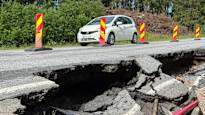
Heavy weekend rains in Finland caused 16 gravel road collapses, primarily in the Pirkanmaa and Central Finland regions, with one paved road section also collapsing in Ylöjärvi; repair crews have restored most routes but a few roads remained closed Monday morning. [2] Väylävirasto reports that it has had to repair roads at 16 different sites following the weekend rains. [2] In the weekend rains in Finland, gravel roads went out of service at 16 different locations. [2] A large part of the gravel roads broken in the heavy rain are located in Pirkanmaa and Central Finland. [2] The situation was exceptional according to Väylävirasto. [2] One rain event has not caused this many gravel road collapses at once, states Väylävirasto's road maintenance expert Jarkko Pirinen. [2] Repair work began as soon as information about the broken roads reached contractors. [2] In Saarijärvi, Molosuntintie has already been repaired. [2] In Ylöjärvi, the paved old Kuruntie road 2774 collapsed at the edge of the road a little north of Ylinen. [2] The damage was influenced by the weekend heavy rain. [2] The damaged section now has one lane closed. [2] In Central Finland, a few roads remained closed Monday morning in Multia and one road in Keuruu. [2] Repair crews have restored most routes but some roads stayed closed into Monday morning. [2] The 16 sites required repairs after the weekend rains primarily affected Pirkanmaa and Central Finland regions. [2]
Officials Cite Changing Rainfall Patterns
Finnish officials described the rainfall intensity as equivalent to more than a meter of snow in winter terms and noted that such extreme summer downpours, once occurring once every decade or three, are becoming an annual occurrence linked to climate trends. [2] The force of this rain is the challenge, as 100 mm in 24 hours corresponds to more than a meter of snow in winter terms, describes Pirinen. [2] Heavy rains are already a new normal according to Pirinen. [2] When they used to come once every ten or thirty years, now they can come annually. [2] Preventing collapses completely in advance is not possible because there are many gravel roads and the increase in summer rains brought by climate change cannot be predicted. [2] Roadside collapses on gravel roads occur practically every summer. [2] The structure of gravel roads is also a problem because most of them are old and shaped by use. [2] There is no precise information on the structures and their durability. [2] Roadside rainwater culverts may also be outdated and do not pass water in the way required by current construction requirements. [2] When roads and rainwater culverts are replaced with new ones, the diameter and at the same time the water transport capacity increases by 20 percent. [2] In some cases, gravel roads are also deliberately cut off so that water damage caused by a broken culvert remains smaller. [2] The extent of the weekend damage in Central and Inner Finland areas is of particular interest. [2] Damage impacts and repair costs are being assessed because the damaged road network also affects the functioning of society. [2] In Central Finland, repairs to collapsed roads have been underway since Sunday. [2] Repairs have been complicated by the fact that some roads were completely covered by water. [2]
What to watch next includes continued monitoring of the Red Flag Warning conditions through 9 PM CDT Wednesday in the affected North Dakota counties and the possibility of tropical storm force winds until Tuesday evening in the specified Gulf of Mexico waters.






/file/attachments/orphans/BM-Ed-ElNinoAucamp3_433491.jpg)