
Satellite Data Shows Anak Krakatau Grows by 33 Hectares After September Eruptions Amid Natural Disasters
Two small island-like landforms have been detected near Anak Krakatau in Indonesia's Sunda Strait following continuous eruptions from September 4 to 6 2026 amid natural disasters, with the volcano itself growing by nearly 33 hectares from deposited pyroclastic material and lava flows. [1]
New Landforms Detected Near Anak Krakatau
Sentinel satellite imagery showed two landforms northwest and southeast of Anak Krakatau believed to result from fluid magma released during the eruptions. [1] Anak Krakatau gained about 32.8 hectares in its northwest, west and southwest sectors due to the same eruptive activity. [1] The assessment of the two formations remains preliminary and requires on-site verification and before-and-after satellite comparison. [1] Satellite imagery also showed the volcano itself has grown by nearly 33 hectares after about 25 hours of continuous eruptions earlier this month. [1] The two landforms appeared near Anak Krakatau in the Sunda Strait after the eruptions, according to Centre for Volcanology and Geological Hazard Mitigation head Siti Sumilah Rita Susilawati. [1]
Preliminary Scientific Interpretation
The Centre for Volcanology and Geological Hazard Mitigation's initial explanation links the formations to magma release and material deposition. [1] Fluid magma released during the continuous eruption reached the surface through an opening extending from northwest to southeast, causing eruptive material to form land at other locations that appeared as two island-like mounds. [1] Apart from the two formations, the satellite imagery also showed Anak Krakatau itself had gained about 32.8 hectares of land in its northwest, west and southwest sectors due to deposits of pyroclastic material and lava flows from the same eruptions. [1] Based on evaluation of Sentinel satellite imagery, there was addition of land on the body of Mount Anak Krakatau in the northwest to west-southwest sectors estimated to come from deposition of pyroclastic material and lava flows due to eruptions from 4 to 6 September 2026. [2] The Geological Agency calculated the addition of land area at about 32.8 hectares. [2]
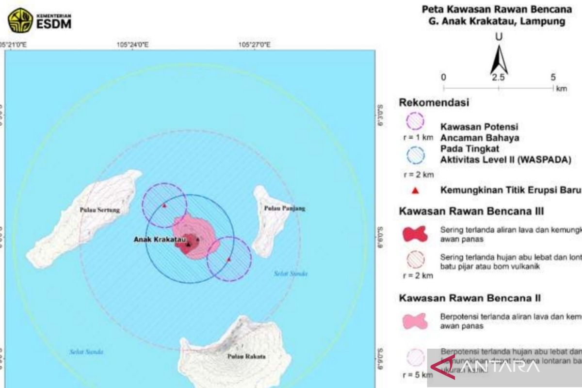
Satellite imagery reveals two new landforms near Anak Krakatau after September 2026 eruptions. — Source: gdelt
Context of Recent Eruptive Activity Amid Natural Disasters
The sequence of eruptions in July and September 2026 produced the lava flows, pyroclastic deposits and morphological changes. [2] Anak Krakatau experienced eruptions again since 2 July 2026 after previously having a fairly long pause in activity. [2] On 5 September 2026, Anak Krakatau experienced continuous eruptions accompanied by rumbling sounds. [2] The phenomenon also produced lava flows and was said to resemble a lava fountain. [2] On 8 September 2026, Anak Krakatau experienced two more eruptions, each at 05.08 WIB and 05.34 WIB. [2] Activity was recorded through a seismograph even though the ash column was not observed visually from the observation post. [2] The emergence of morphological changes was related to increased volcanic activity of Anak Krakatau throughout 2026. [2] The Geological Agency noted that Anak Krakatau experienced eruptions again since 2 July 2026. [2]
Current Alert Status and Safety Recommendations
The downgrade to Level II and the specific exclusion zones established for public safety have been reported. [1] Anak Krakatau’s alert status was lowered on Sept 21 from Level III, the second-highest level in Indonesia's four-tier volcano alert system, to Level II following a decline in volcanic activity. [1] Under the current alert level, the public was urged to remain calm and stay at least two kilometres from the eruption centre and one kilometre from the two newly detected formations. [1] The Geological Agency appealed to the public not to approach within a radius of 2 kilometres from the eruption centre. [2] Specifically for the location of the two mounds visible around Anak Krakatau, the public was asked not to approach within a radius of 1 kilometre for safety. [2]

Satellite imagery reveals new landforms near Anak Krakatau after September 2026 eruptions. — Source: antaranews
Distinction from New Volcano Formation
Expert views indicate that the visible material represents accumulated volcanic deposits rather than an independent new volcano or permanent island pending field checks. [2] The emergence of material protruding from the sea surface does not mean a new volcano has been formed. [2] Volcanic material that comes out during an eruption can accumulate around the body of the mountain and form changes in the morphology of the area. [2] The land visible is purely an accumulation of volcanic material deposits. [5] It was formed from the accumulation of eruption residual material such as ash, rocks and lava that settled gradually in the sea until it finally emerged to the surface. [5] In fact, this land is not an independent volcano, but an accumulation of volcanic material from the eruption of Mount Anak Krakatau that settled in the sea. [5] The process of accumulation takes place gradually along with increasing activity of the mountain. [5]
Need for Further Verification
The planned satellite comparisons and on-site inspections required to confirm the nature and stability of the new landforms have been outlined. [1] The assessment remained preliminary, with the agency planning to compare satellite imagery before and after the eruptions and conduct on-site verification. [1] The existence of the two mounds cannot yet be confirmed as an island or new volcano. [2] The interpretation is still temporary and needs to be confirmed through direct checks in the field. [2] Verification is carried out by matching satellite images before and after the eruption as well as conducting field inspections. [2] To state for certain that new land has been formed due to Anak Krakatau activity, observation and monitoring of the volcano's morphology is required. [2] The emergence of land forms in visual recordings needs to be compared with conditions before and after the eruption and verified through field observations. [2]
What to watch next includes further satellite comparisons before and after the eruptions along with on-site verification to confirm the two formations, while the alert remains at Level II with the specified exclusion zones in place.