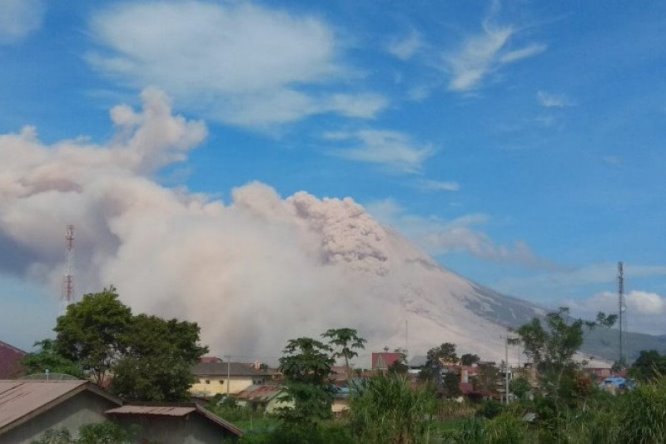

Indonesian Authorities Evacuate 650 from Sinabung Amid Natural Disasters and Enforce 3 km Zone at Anak Krakatau after Eruptions
Mount Sinabung in North Sumatra and Anak Krakatau in the Sunda Strait both erupted in early September 2026, prompting Indonesian authorities to raise alert levels, urge evacuations from danger zones, and distribute aid while assuring coastal residents there is no immediate tsunami risk amid natural disasters.
Dual Volcanic Eruptions in Indonesia as Natural Disasters Strike
Gunung Sinabung erupted on 31 August 2026 with a 3,500-meter ash column, leading PVMBG to raise its status from Level II to Level III (Siaga); activity included hot ash clouds traveling up to 3,000 meters. [1] Anak Krakatau began erupting on 4 September at 23:07 WIB, producing lava fountains, a continuous eruption earthquake lasting over six hours, loud booms heard as far as Bandung Raya, Banten, and Lampung, and red-glowing ejections; its status remains at Level III. [3] [5] BNPB and PVMBG state that post-2018 growth of Anak Krakatau is limited and does not risk a massive collapse capable of generating a tsunami, urging calm in Banten and Lampung coastal areas while enforcing a 3-kilometer exclusion zone. [3] [5] Authorities are patrolling restricted zones around both volcanoes, including Lake Lau Kawar near Sinabung, and coordinating with TNI and Polri; volcanic ash from Sinabung is damaging farmland whose extent is still being assessed. [1] [4]
Sinabung Alert Raised to Level III
Gunung Sinabung erupted on 31 August 2026 with a 3,500-meter ash column, leading PVMBG to raise its status from Level II to Level III (Siaga). [1] [4] From results of visual and instrumental monitoring, volcanic activity at Gunung Sinabung increased so the activity level was raised from Level II (Waspada) to Level III (Siaga). [1] The eruption on Monday, Aug. 31, spewed an ash column 3,500 meters above the peak. [4] According to observations from the Mount Sinabung monitoring post on Friday between 12:00 a.m. and 6:00 p.m. local time, thick white volcanic ash was seen rising 300 to 500 meters above the crater. [4] Gunung Sinabung experienced an eruption accompanied by hot ash clouds twice with a maximum travel distance of 3,000 meters on Thursday. [1] The impacts of current volcanic activity were felt in several areas, especially Ndokum Siroga Village and Kuta Tengah Village in Simpang Empat Sub-district as well as Payung Village in Payung Sub-district. [1]
Evacuation and Humanitarian Measures for Sinabung
As of 4 September, 208 families (650 people) from affected villages including Ndokum Siroga, Kuta Tengah, and Payung had evacuated, with 405 staying at Jambur Arih Ersada shelter in Sukatepu; local government is updating data and providing masks, clean water, and public kitchens. [1] [4] As of Friday, Sept. 4, a total of 208 families, or 650 people, had evacuated. [4] Of these, 405 people are currently staying at the Jambur Arih Ersada evacuation center in Sukatepu Village, Naman Teran Sub-District. [4] The Karo Regency Government, alongside the Regional Disaster Management Agency (BPBD), Public Order Agency (Satpol PP), Indonesian Military (TNI), and National Police (Polri), has secured hazardous areas, including Lake Lau Kawar. [4] Based on patrols, the area has been confirmed to be free of visitors. [4] Emergency response measures include running public kitchens three times daily, providing clean water, and relocating classes for students of SD Negeri 040475 Tiga Serangkai to an emergency learning site. [4] Payung Village in Payung District has temporarily been placed on standby. [4] Junior high school students attending schools outside the village are being provided with transportation by the Karo Regency Satpol PP. [4] Local authorities, together with relevant agencies, are directing residents in areas affected by volcanic ash to evacuate to safer locations and distributing masks to minimize health risks. [4] BPBD Kabupaten Karo has distributed masks to people affected by volcanic dust. [1] The local government continues to update data to ensure the needs of affected residents can be met appropriately. [1] Volcanic ash also impacted community agricultural land, with the extent and level of damage still being recorded by related parties. [1]
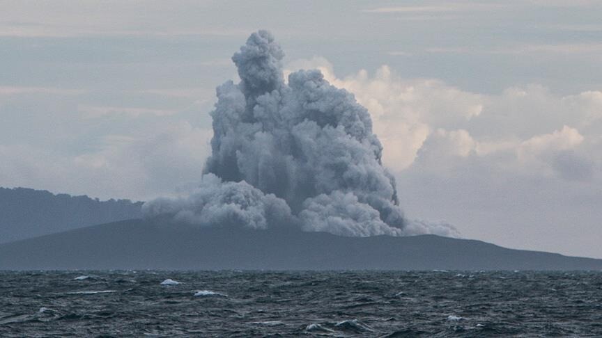
Anak Krakatau volcano erupts spewing rocks and volcanic ash into the air. — Source: gdelt
Anak Krakatau Eruption Details and Booms
Anak Krakatau began erupting on 4 September at 23:07 WIB, producing lava fountains, a continuous eruption earthquake lasting over six hours, loud booms heard as far as Bandung Raya, Banten, and Lampung, and red-glowing ejections; its status remains at Level III. [3] [5] The ongoing eruption, which began on Friday at 11:07 p.m. local time and continued into Saturday morning, was observed producing lava fountains at night and triggering one eruption earthquake with an amplitude of 70 millimeters and a duration of up to 21,600 seconds. [3] The continuous eruption of Mount Anak Krakatau in the Sunda Strait on Saturday (5/9/2026) was suspected to be the cause of booming sounds and vibrations felt by residents in three provinces, including Bandung Raya. [5] The eruption activity lasted from 23:07 WIB until at least 04:40 WIB. [5] Reports of booming sounds and vibrations came from several areas in West Java, including Bandung Raya, Banten, and Lampung. [5] The time of the phenomenon coincided with the eruption activity of Mount Anak Krakatau monitored by the Center for Volcanology and Geological Hazard Mitigation (PVMBG). [5] The continuous eruption over several hours associated with lava fountain eruptions is a common phenomenon. [5] The booming sounds and vibrations felt by the public were strongly suspected to be related to the eruption activity of Mount Anak Krakatau at the same time. [5] The phenomenon can occur due to rapid gas release as well as friction and turbulence of high-speed lava flow inside the conduit or crater hole. [5] Sound waves from Anak Krakatau can propagate far through the atmosphere and eventually be heard in Bandung, although some closer coastal areas may not necessarily hear them clearly. [5] Sound waves or low-frequency air pressure can reach distances of up to hundreds of kilometers through the atmosphere. [5] Atmospheric conditions and wind direction can also affect the travel of sound waves. [5] Changes in temperature, pressure, and wind in certain atmospheric layers can cause sound waves to refract. [5] The path can bend and return to the surface at a location far from the sound source. [5] What was felt in Bandung, which is 700 km (straight line) away, was the boom, with windows and doors vibrating. [5] Based on PVMBG monitoring, the eruption activity during that period was also accompanied by rumbling sounds heard as far as the Mount Anak Krakatau Observation Post in Pasauran, Banten. [5] Visual observations showed continuous red-glowing ejections. [5] Although the height of the eruption column could not yet be determined, the character of the ejections resembled a lava fountain or lava air mancur phenomenon. [5] The lava fountain phenomenon can produce lava flows. [5]
No Tsunami Risk from Anak Krakatau
BNPB and PVMBG state that post-2018 growth of Anak Krakatau is limited and does not risk a massive collapse capable of generating a tsunami, urging calm in Banten and Lampung coastal areas while enforcing a 3-kilometer exclusion zone. [3] [5] An evaluation done by the Center for Volcanology and Geological Hazard Mitigation (PVMBG) found the growth of Mount Anak Krakatau's volcanic edifice since 2018 remains relatively limited and does not pose a risk of a massive collapse that could trigger a tsunami. [3] Therefore, residents in Banten and Lampung will not panic. [3] The government is also closely monitoring the potential for a tsunami triggered by Mount Anak Krakatau's activity. [3] Based on evaluation results to date, the growth of Mount Anak Krakatau's body that reformed after the December 22, 2018 eruption remains relatively small and does not have the potential for collapse on a scale that could trigger a tsunami. [5] Residents are urged to remain calm and not panic. [5] The activity of Mount Anak Krakatau remains at Level III or Siaga. [5] The status has been set since 2 July 2026. [5] In response to the Mount Anak Krakatau's continued Level III (Alert) activity, the BNPB and PVMBG have recommended that residents, fishermen, and tourists suspend all activities within a three-kilometer danger radius from the active crater. [3] The radius 3 kilometers from the center of Mount Anak Krakatau activity must be cleared of community activities, visitors, tourists, and climbers. [5] This provision must be obeyed because the potential for lava flows and ejection of incandescent material can still occur. [5] Residents in coastal areas of Banten and Lampung are urged to remain calm. [3] Residents in coastal areas of Banten and Lampung are advised to continue their activities as usual while still paying attention to official government information developments. [5]
Ongoing Government Coordination
Authorities are patrolling restricted zones around both volcanoes, including Lake Lau Kawar near Sinabung, and coordinating with TNI and Polri; volcanic ash from Sinabung is damaging farmland whose extent is still being assessed. [1] [4] Coordination in handling the impacts of the eruption was also carried out together with elements of the TNI and Polri. [1] One of them is through the Sinabung Volcano Observation Post in Ndokum Siroga Village, Simpang Empat Sub-district. [1] Patrols were also carried out at several locations that have been designated as prohibited areas for activities and visits. [1] This includes the Lake Lau Kawar area. [1] From the results of the patrols, the area was confirmed to have no visitors. [1] The BNPB Operations Control Directorate confirmed that the ejected volcanic material had damaged observation equipment, including cameras and closed-circuit television (CCTV) systems, causing them to stop operating. [3] Three key priorities in managing the situation include enforcing sterilisation of danger zone through patrols by local governments and Regional Disaster Management Agencies, ensuring readiness of evacuation routes and assembly points along the coast, and urging residents not to approach the site merely to document the eruption. [3] The Karo Regency Government continues to update data to ensure the needs of affected residents can be met appropriately. [1] BPBD also distributed masks to communities affected by volcanic dust. [1] Emergency response measures include running public kitchens three times daily and providing clean water. [4] The public is urged not to easily believe unverified information, especially information regarding the possibility of a tsunami. [5] The public is asked to remain vigilant against potential eruption hazards, including the spread of volcanic ash, but does not need to panic. [5] If volcanic ash rain occurs, residents in affected areas are advised to use respiratory protection and follow official directions from the Geological Agency, PVMBG, and local BPBD. [5] Official information can be obtained through the Center for Volcanology and Geological Hazard Mitigation at number (022) 7272606 or the Krakatau Volcano Observation Post at (0254) 651449/085846324506. [5] Developments in Mount Anak Krakatau activity can also be monitored through the MAGMA Indonesia application, official websites, and social media of the Ministry of Energy and Mineral Resources, the Geological Agency, and PVMBG. [5]
What to watch next: PVMBG will continue monitoring and evaluation of Mount Anak Krakatau activity developments while authorities keep patrols active around restricted zones at both volcanoes.