
Hurricane Tracker Shows Typhoon Champi Weakening Near Taiwan With Flights Canceled
The hurricane tracker indicates Taiwan shut down on October 23 ahead of Typhoon Champi, which is forecast to bring strong winds and heavy rain despite weakening, while the same system continues to affect parts of the northern Philippines as Rosal and separate flood warnings remain in effect in southwestern Colorado.
Taiwan Shutdown as Typhoon Champi Approaches
Almost all of Taiwan shut down on Friday, October 23, ahead of the arrival of Typhoon Champi. The transport ministry said all 262 domestic flights were canceled for Friday, along with 669 international ones. Taiwan’s financial markets also closed on Friday. The government said almost 1,300 people had been evacuated from mountainous areas. Coastal towns received mobile phone alerts warning of gusts exceeding 150 kph and urging residents to seek immediate shelter. In the capital Taipei there were squally showers, but public transport including the subway was working, albeit with reduced service. The north-south high-speed rail service was operating as usual. Only the Taiwan-controlled Kinmen islands, which sit next to the Chinese coast, will open schools and offices as normal. [3]
Storm Strength, Track and Impacts on Taiwan
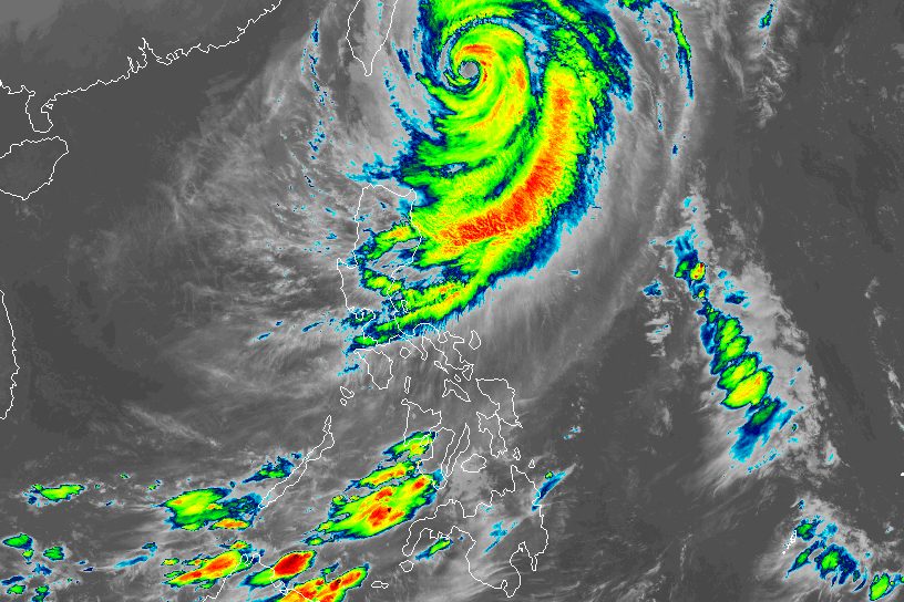
At one point a super typhoon and one of the strongest storms in the Pacific this year, Champi was still packing gusts of around 191 kph near its center, according to Taiwan’s Central Weather Administration. The storm was about 320 km east of Taiwan’s southern tip. The storm’s forecast track shows it will pass just off northeastern Taiwan, turn north toward the Chinese coast and eventually move into southern Japan. One person was killed and 94 were injured in Taiwan. Nearly a metre of rain was forecast for northern mountain areas, including around Taipei. Taiwan forecasters said the storm’s radius was around 320 km, large enough to cover most of Taiwan, and weather experts said its impact could last nearly two days. [4]
Philippine Effects from Typhoon Rosal
Typhoon Rosal (Champi) continued to affect Batanes and other parts of Northern Luzon on Friday, October 23, even though it has spared the Philippines from landfall. Rosal was last spotted 275 kilometers east northeast of Itbayat, Batanes, as of 4 am on Friday. The typhoon is moving northwest at only 15 kilometers per hour. Its maximum sustained winds had weakened to 155 km/h on Thursday evening, October 22, while its gustiness eased to 190 km/h. PAGASA said in a bulletin issued at 5 am on Friday that Rosal is still bringing moderate to heavy rain to Batanes in the coming hours. Tropical cyclone wind signals also remain in effect. Warnings for seaboards affected by Rosal have yet to be lifted, with waves up to 12 meters high in northern and eastern seaboards of Batanes. Rosal may exit the Philippine Area of Responsibility by early Saturday morning, October 24. [5]
Flood Warnings Issued in Colorado
Flooding caused by excessive rainfall continues in western Archuleta County in southwestern Colorado until 200 AM MDT. Flooding of rivers, creeks, streams, and other low-lying and flood-prone locations is imminent or occurring. Streams continue to rise due to excess runoff from earlier rainfall. Flooding caused by excessive rainfall is expected in northeastern San Miguel County in southwestern Colorado until 945 AM MDT Friday. Low-water crossings are inundated with water and may not be passable. Similar warnings cover southern Hinsdale County and southern La Plata County in southwestern Colorado. [1]
Preparations and Outlook
In the northeastern county of Yilan, where strong winds and heavy showers were intensifying and the typhoon was forecast to pass close by later on Friday, authorities distributed sandbags and put amphibious vehicles and inflatable rescue boats on standby. “When necessary, the military will come in to help people, including using amphibious vehicles for evacuations or disaster relief,” said Lee Ming-chen, head of the port town of Suao. After leaving PAR, Rosal is likely to be downgraded to a severe tropical storm by Saturday morning, then weaken further into a tropical storm by Saturday evening. The typhoon is forecast to first pass over Japan’s westernmost inhabited island, Yonaguni, in Okinawa Prefecture. [3]
What to watch next: The storm is projected to exit the Philippine Area of Responsibility by early Saturday morning, October 24, after which it is expected to weaken further while moving toward southern Japan.