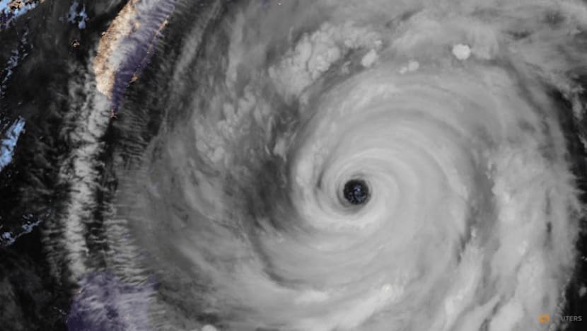
Hurricane Tracker Shows Tropical Storm Krovanh Fueling Heavy Rains and Landslide Warning Near Tokyo
Severe thunderstorms are producing damaging winds and large hail across parts of the central and eastern United States while heavy rains triggered by an approaching tropical system are lashing the Tokyo region of Japan, prompting the highest-level landslide warning for one island. Hurricane tracker observations indicate the tropical moisture is intensifying the pattern over Japan.
Active Severe Thunderstorm Warnings in the United States
A Severe Thunderstorm Warning is in effect until 7:30 PM CDT for portions of northeastern Kansas and northwestern Missouri near Atchison and Easton, with a storm producing 60 mph wind gusts and quarter-size hail. [1] At 6:45 PM CDT, a severe thunderstorm was located near Easton, or 8 miles south of Atchison, moving north at 10 mph. [1] The hazard includes 60 mph wind gusts and quarter size hail according to radar indicated sources. [1]
A Severe Thunderstorm Warning covers central McKenzie County in northwestern North Dakota until 7:45 PM CDT, with golf-ball-size hail and 60 mph winds reported. [2] At 6:44 PM CDT, a severe thunderstorm was located 8 miles south of Alexander, or 16 miles west of Watford City, moving northeast at 15 mph. [2] The hazard includes golf ball size hail and 60 mph wind gusts from radar indicated sources. [2]
Severe thunderstorms moving northeast at 35 mph are affecting rural areas of Carter County, Montana, bringing 60 mph winds, quarter-size hail and brief heavy rain. [4] At 5:41 PM MDT, a severe thunderstorm was located 22 miles northeast of Ridgeway, or 29 miles southeast of Ekalaka, moving northeast at 35 mph. [4] The hazard includes 60 mph wind gusts and quarter size hail, along with brief heavy rain from radar indicated sources. [4]
A Severe Thunderstorm Warning covers portions of Jenkins County in southeastern Georgia, Screven County in southeastern Georgia, Allendale County in southeastern South Carolina, Colleton County in southeastern South Carolina and Hampton County in southeastern South Carolina until 8:45 PM EDT. [5] At 7:38 PM EDT, severe thunderstorms were located along a line from 10 miles north of Smoaks to 19 miles north of Perkins, moving. [5]
Heavy Rain and Landslide Emergency in Japan
Heavy rains have inundated Tokyo, Chiba and Kanagawa Prefectures, closing schools, reducing train service by 20-30 percent and prompting a level-5 landslide emergency warning for Niijima island. [3] The Japan Meteorological Agency issued a level 5 emergency warning for landslides for Tokyo’s Niijima island, some 160 kilometers south of the capital, as of 4:15 a.m. Monday. [3] The warning is the highest level of alert on the agency’s scale of 1 to 5. [3] The heavy rains were also inundating areas of the capital further north, as well as Chiba and Kanagawa Prefectures. [3] A level 4 warning for heavy rain was issued for the city of Chiba early Monday. [3] Rainfall of more than 50 millimeters per hour is forecast for the Kanto region until shortly before noon Monday. [3] Some elementary and middle schools in Tokyo, as well as in Chiba and Kanagawa Prefectures, have cancelled classes. [3] Commuters were also impacted, with JR East’s Yamanote Line, Chuo Line, Sobu Line and Tokaido Line all seeing operations with 20% to 30% fewer trains on Monday. [3]
Tropical Storm Krovanh's Influence
Tropical Storm Krovanh is forecast to bring additional moisture to the Kanto region, with up to 300 mm of rain possible in parts of Japan through Monday night. [3] The storm front is forecast to continue moving north, with Tropical Storm Krovanh expected to send warm, damp air toward it. [3] Krovanh was moving north-northeast over waters 50 km north-northeast of Minamidaito Island in Okinawa Prefecture. [3] The 24-hour rainfall through Monday night was forecast to reach as much as 300 millimeters in the Tokai region, 250 millimeters in the Kanto-Koshin area and as much as 200 millimeters in the Tohoku and Kinki regions and in the area of the Izu Islands. [3] Hurricane tracker monitoring highlights how this tropical moisture sustains the heavy rain threat across multiple regions.
Hazards and Immediate Impacts
People and animals outdoors will be injured from the North Dakota storm. [2] Expect hail damage to vehicles from the Montana storm. [4] Expect wind damage to roofs, siding, and trees from the Montana storm. [4] The agency is urging people to be on high alert for landslides, rising river levels and floods in some low-lying areas in Japan. [3] Locations impacted by the Montana storm include mainly rural areas of East Central Carter County. [4]
Ongoing Monitoring and Forecasts
The storm in Kansas was moving north at 10 mph until 7:30 PM CDT. [1] The storm in North Dakota was moving northeast at 15 mph until 7:45 PM CDT. [2] The storm in Montana was moving northeast at 35 mph. [4] The storm front is forecast to continue moving north. [3] Rainfall of more than 50 millimeters per hour is forecast for the Kanto region until shortly before noon Monday. [3]
What to watch next: The storm front is forecast to continue moving north with Tropical Storm Krovanh expected to send warm, damp air toward it while rainfall totals reach as much as 300 millimeters in the Tokai region through Monday night.