Hong Kong Issues Amber Rainstorm Warning as Texas Faces Flash Floods and Southwest New Mexico Sees Fire Weather Alerts
Hong Kong issued an amber rainstorm warning Tuesday as persistent heavy showers and thunderstorms from a trough of low pressure affect the region, while parts of Texas face ongoing flash flooding and the U.S. Southwest contends with critical fire weather conditions.
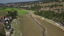
Hong Kong Under Amber Rainstorm Warning
The Hong Kong Observatory issued an amber rainstorm warning at 6.15pm on Tuesday. [1] This warning signals that more than 30mm of rain had fallen or was expected to fall across the city within an hour. [1] Heavy showers and squally thunderstorms associated with the southwest monsoon and a trough of low pressure are affecting the coast of Guangdong and the northern part of the South China Sea persistently. [1] The forecaster said downpours were likely to continue. [1] Unsettled weather is expected over the next few days. [1]
Forecast for Continued Heavy Showers in Southern China
The trough would continue to influence the region in the coming days. [1] This influence brings further heavy showers and thunderstorms. [1] With the subtropical ridge over the western North Pacific forecast to extend westwards later in the week, showers over Guangdong were expected to ease gradually. [1] The Hong Kong Observatory noted that the unsettled weather linked to the southwest monsoon and trough of low pressure affects the Guangdong coast and northern South China Sea. [1]
{IMAGE_2}
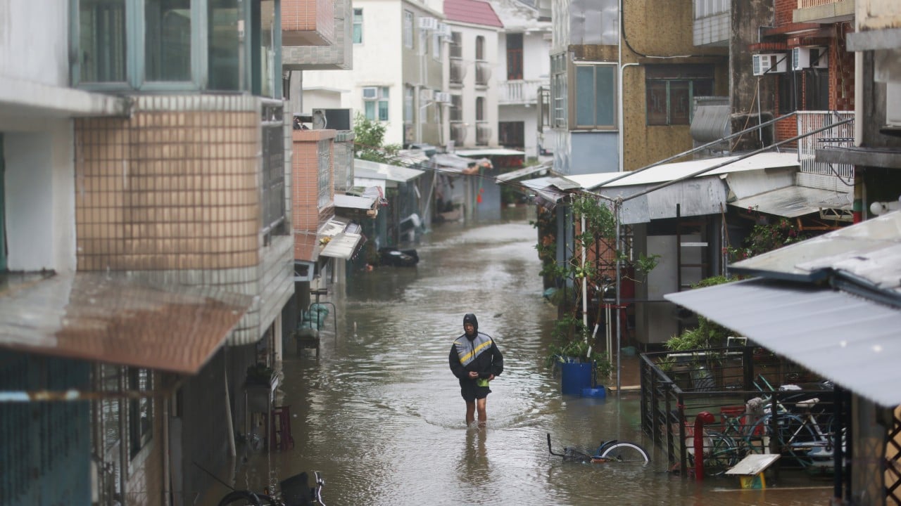
Flash Flooding Strikes Northwestern Duval County, Texas
The National Weather Service in Corpus Christi has issued a Flash Flood Warning for Northwestern Duval County in south central Texas. [2] The warning is in effect until 800 AM CDT. [2] At 504 AM CDT, Doppler radar indicated thunderstorms producing heavy rain across the warned area. [2] Between 2 and 3 inches of rain have fallen. [2] Additional rainfall amounts of 1 to 2 inches are possible in the warned area. [2] Flash flooding is ongoing or expected to begin shortly. [2] The hazard is flash flooding caused by thunderstorms. [2]
Critical Fire Weather Conditions Across New Mexico Regions
A Red Flag Warning is in effect from 1 PM to 7 PM MDT Tuesday due to strong winds and low relative humidity for the Northwest Plateau. [3] A Fire Weather Watch remains in effect from Wednesday afternoon through Wednesday evening due to strong winds and low relative humidity for the Northwest Plateau, the West Central and North Central Mountains, Middle Rio Grande Valley, Sandia and Manzano Mountains, and Central Highlands. [3] Hot, dry, and windy conditions develop over the Northwest Plateau. [3] The same Red Flag Warning from 1 PM to 7 PM MDT Tuesday applies due to strong winds and low relative humidity for the Northwest Plateau. [4] The Fire Weather Watch from Wednesday afternoon through Wednesday evening covers the Northwest Plateau, the West Central and North Central Mountains, Middle Rio Grande Valley, Sandia and Manzano Mountains, and Central Highlands. [4] Hot, dry, and windy conditions develop over the Northwest Plateau. [4] The Red Flag Warning from 1 PM to 7 PM MDT Tuesday is due to strong winds and low relative humidity for the Northwest Plateau. [5] The Fire Weather Watch remains in effect from Wednesday afternoon through Wednesday evening due to strong winds and low relative humidity for the Northwest Plateau, the West Central and North Central Mountains, Middle Rio Grande Valley, Sandia and Manzano Mountains, and Central Highlands. [5] Hot, dry, and windy conditions develop over the Northwest Plateau. [5]
Broader Pattern of Global Severe Weather Alerts
The Hong Kong Observatory issued an amber rainstorm warning at 6.15pm on Tuesday after more than 30mm of rain had fallen or was expected within an hour. [1] Heavy showers and squally thunderstorms from the southwest monsoon and trough affect the Guangdong coast and northern South China Sea. [1] The National Weather Service issued a Flash Flood Warning for Northwestern Duval County until 800 AM CDT after 2 and 3 inches of rain fell. [2] Additional rainfall of 1 to 2 inches remains possible. [2] Red Flag Warnings and Fire Weather Watches cover multiple New Mexico areas including the Northwest Plateau, West Central and North Central Mountains, Middle Rio Grande Valley, Sandia and Manzano Mountains, and Central Highlands. [3] These alerts stem from strong winds, low relative humidity, and hot dry conditions. [3]
What to watch next: The trough of low pressure is expected to continue influencing the region in the coming days before the subtropical ridge extends westwards and showers ease gradually.