
Earthquakes Today Strike Regions From China to Vietnam and Peru
Multiple earthquakes today struck various regions worldwide in mid-October 2026, including a magnitude 5.0 event in China, a magnitude 4.2 quake in Vietnam that caused a rockslide and minor structural collapse, a magnitude 4.1 tremor in Timor Leste, and a series of smaller seismic events across Peru. [2] [1] [4] [3]
Recent Earthquakes Worldwide
A magnitude 5.0 earthquake occurred at a depth of 10.0 km, 31 km northwest of Jiangyou, China. [2] Two consecutive earthquakes hit Son La Province in northern Vietnam on October 19, 2026: a magnitude 2.6 followed by a magnitude 4.2 at about 12 km depth, causing a large rock to roll into a house and collapse part of its kitchen with no injuries reported. [4] A magnitude 4.1 earthquake struck at a depth of 152.7 km, 192 km northeast of Lospalos, Timor Leste. [1] Peru recorded at least 15 earthquakes between October 10 and 18, 2026, with magnitudes ranging from 3.5 to 5.1, primarily in regions including Arequipa, Lima, Junín, and Ica; the strongest was a magnitude 5.1 near Quilca on October 11. [3] These events reflect ongoing global seismic patterns documented across multiple monitoring sources.
The China event registered precisely as magnitude 5.0 at the stated depth and location according to USGS data. [2] The Timor Leste quake matched the exact parameters of magnitude 4.1 at 152.7 km depth and 192 km northeast of Lospalos. [1] In Vietnam, the sequence unfolded on October 19, 2026, with the initial magnitude 2.6 at 6:35 am followed roughly 25 minutes later by the magnitude 4.2. [4] Peru's cluster spanned the listed dates with the noted magnitude range and epicenters, all tracked by the Instituto Geofísico del Perú. [3] No additional events beyond these specifics appear in the available records.
Impact in Vietnam
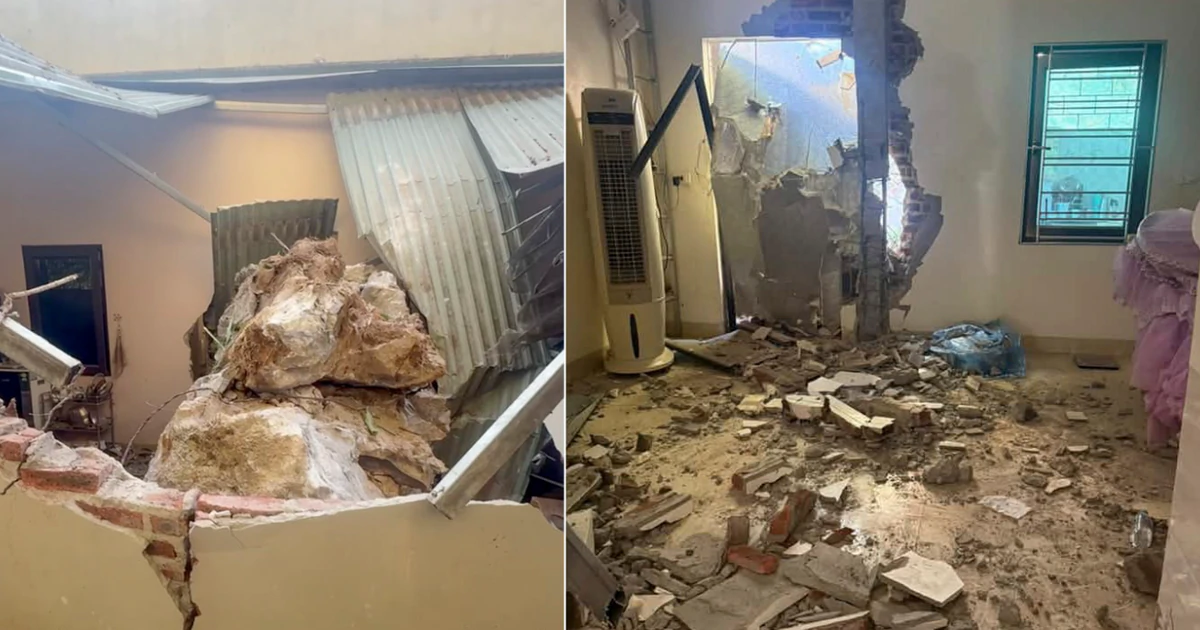
A magnitude 4.2 earthquake struck Son La Province in northern Vietnam on October 19 2026. — Source: gdelt Two consecutive earthquakes hit Son La Province in northern Vietnam on October 19, 2026: a magnitude 2.6 followed by a magnitude 4.2 at about 12 km depth, causing a large rock to roll into a house and collapse part of its kitchen with no injuries reported. [4] Residents living near the epicenter reported feeling noticeable shaking during the second earthquake. [4] A large rock rolled down a hill behind a house in Mai Son Commune following the magnitude 4.2 earthquake, said an official of the commune. [4] The boulder, estimated to weigh several cubic meters, rolled into the kitchen of a house belonging to a woman identified as H., causing part of the structure to collapse. [4] Fortunately, no one was inside the kitchen when the rock struck. [4]
Tong Hoang, a resident of Chieng Coi Ward, said the first tremor caused only slight shaking. [4] The second, which occurred shortly before 7:00 am, lasted some five to seven seconds, shaking his entire house and producing a deep rumbling sound. [4] Nguyen Xuan Anh, director of the Institute of Earth Sciences under the Vietnam Academy of Science and Technology, said two consecutive quakes had occurred in the commune. [4] The institute initially assessed both earthquakes as posing no disaster risk, assigning them a disaster risk level of zero. [4] The Earthquake Information and Tsunami Warning Center, under the institute, continues to monitor the seismic activity. [4] Son La has experienced stronger earthquakes in the past, including a magnitude 5.3 in 2020 that caused considerable damage to homes and infrastructure, and a magnitude 4.0 in Muong Hung Commune in May 2026 that caused noticeable shaking. [4] In Vietnam, earthquakes measuring magnitude 4 to 5 are generally classified as light tremors where household objects may shake and produce noise, and many people indoors can feel the shaking. [4]
Seismic Activity in Peru
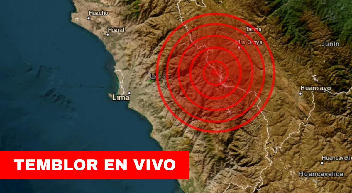
Peru recorded at least 15 earthquakes between October 10 and 18, 2026, with magnitudes ranging from 3.5 to 5.1, primarily in regions including Arequipa, Lima, Junín, and Ica; the strongest was a magnitude 5.1 near Quilca on October 11. [3] The Instituto Geofísico del Perú reported the sequence with specific details for each day. On October 18 a magnitude 4 event occurred 38 km southwest of Aplao in Castilla, Arequipa. [3] On October 17 a magnitude 3.5 struck 7 km northeast of Oxapampa in Pasco, and a magnitude 4.1 hit 104 km northeast of Ayabaca in Piura. [3] On October 16 a magnitude 4.2 was recorded 68 km southwest of Quilca in Camaná, Arequipa, alongside a magnitude 3.8 5 km east of Castrovirreyna in Huancavelica. [3] On October 15 events included a magnitude 3.8 25 km northeast of Tarma in Junín and a magnitude 3.6 37 km west of Huacho in Huaura, Lima. [3] On October 14 a magnitude 3.6 occurred 4 km north of Chosica in Lima. [3] On October 13 a magnitude 3.9 struck 20 km east of Huarmey in Áncash. [3] On October 12 a magnitude 4.3 hit 41 km southwest of San Vicente de Cañete in Lima. [3] On October 11 the magnitude 5.1 took place 16 km southwest of Quilca in Camaná, Arequipa, along with a magnitude 3.6 16 km west of Quilca, a magnitude 3.6 39 km north of Coracora in Ayacucho, and a magnitude 4.5 27 km southwest of San Juan de Marcona in Ica. [3] On October 10 a magnitude 3.5 occurred 5 km east of Camaná in Arequipa. [3] The IGP maintains constant monitoring and issues reports with magnitude, depth, epicenter coordinates, and estimated intensity for each event. [3]
Geological Context of Frequent Quakes in Peru
Peru lies within the Pacific Ring of Fire, where the subduction of the Nazca Plate beneath the South American Plate drives frequent seismic activity and contributes to the formation of the Andes. [3] The country sits inside the Cinturón de Fuego del Pacífico, a zone that concentrates near 85 percent of worldwide seismic activity. [3] The principal origin of tremors and earthquakes is the subduction process in which the Nazca Plate moves beneath the South American Plate, accumulating energy that releases as seismic waves of varying intensity. [3] This same geological process has shaped the Cordillera de los Andes. [3] The interaction between the plates causes progressive energy buildup under Peruvian territory; when pressure exceeds rock resistance, energy releases in seismic waves that can be felt hundreds of kilometers from the epicenter. [3] The evolution of the Andes also contributes to seismic generation, with many events of moderate magnitude that can be felt strongly near populated areas. [3] Geophysical studies indicate the Nazca Plate continues its displacement beneath the continent as far as sectors of the Peruvian Amazon. [3]
What Causes Earthquakes
A sismo is the sudden movement of the Earth's crust provoked by the release of accumulated energy inside the planet. [3] According to the IGP these phenomena can be generated by different natural causes including displacement of tectonic plates, reactivation of geological faults, volcanic activity, and in exceptional cases impacts of meteorites or other natural phenomena. [3] Sismicidad can also be induced by certain infrastructure works or large reservoirs. [3] The subduction mechanism explains the events of greatest magnitude recorded in the country's history. [3]
Preparation and Emergency Guidance
The IGP recommends maintaining an updated family emergency plan, identifying evacuation routes in advance, having an equipped emergency backpack, participating in national drills, and consulting information only through official sources. [3] These actions allow faster and more organized response to any emergency. [3] In case of emergency the recommended contacts are Bomberos at 116, Policía Nacional del Perú at 105, SAMU at 106, and INDECI through local and regional authorities. [3]
What to watch next includes continued monitoring by the Earthquake Information and Tsunami Warning Center in Vietnam and ongoing IGP reports from Peru on any additional events in the listed regions.