
Tropical Storm Maymay Makes Landfall in Ilocos Sur With 75 km/h Winds
Maymay Makes Landfall in Northern Philippines
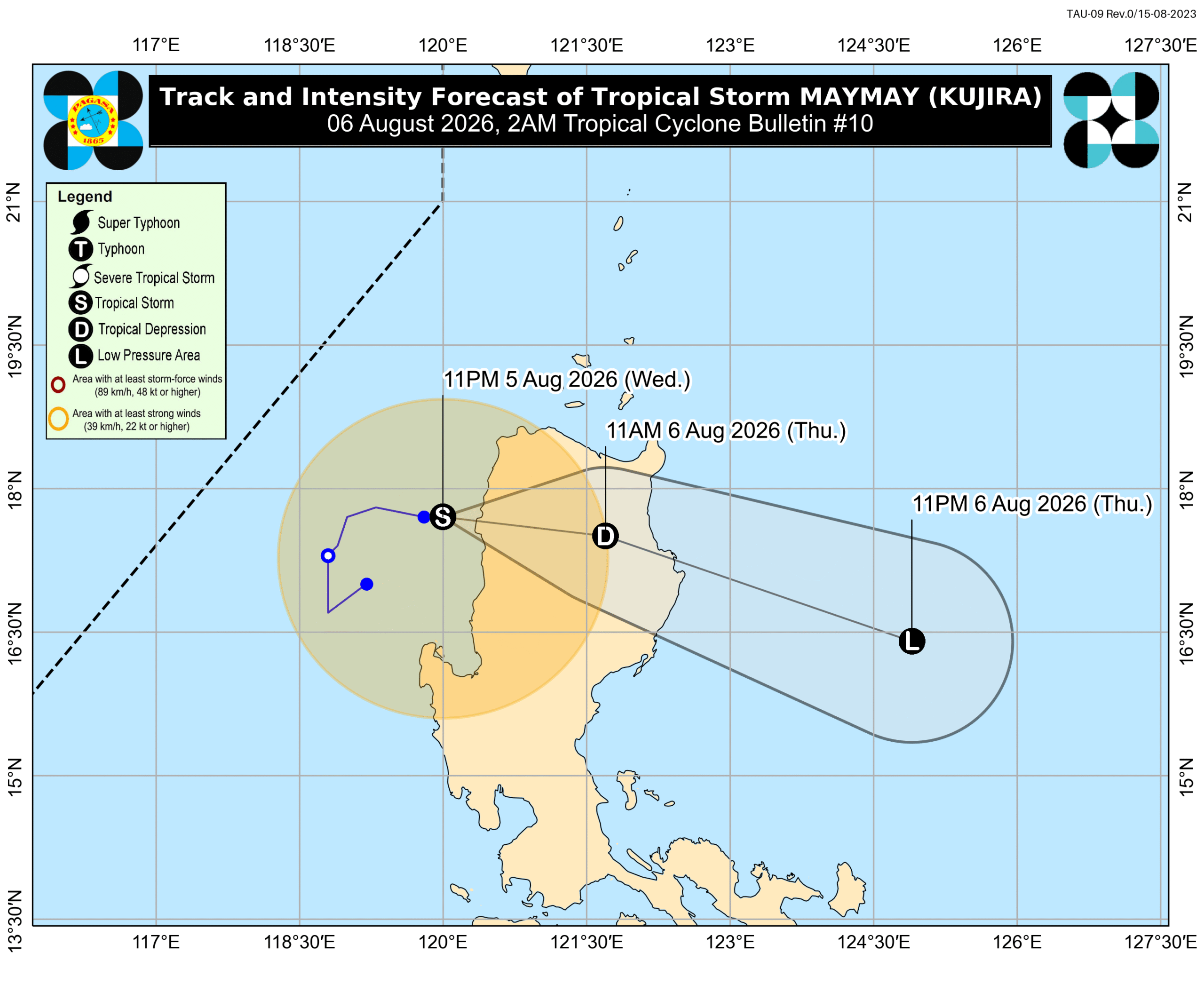
Tropical Storm Maymay made landfall in Magsingal, Ilocos Sur, at 2 am on Thursday, August 6. [2] In its 2 am bulletin, the Philippine Atmospheric, Geophysical, and Astronomical Services Administration had said that Maymay was moving east towards land at just 10 kilometers per hour. [2] The tropical storm continues to have maximum sustained winds of 75 km/h, with gustiness of up to 105 km/h. [2]
Forecast Track and Rapid Weakening
PAGASA expects Maymay to weaken into a tropical depression and subsequently into a low pressure area on Thursday, as it will be crossing the mountainous terrain of Northern Luzon and Central Luzon. [2] The same provinces in Northern Luzon and Central Luzon are still dealing with moderate to torrential rain from Maymay. [2]
Heavy Rainfall Outlook and Flood Risks
Wednesday evening, August 5, to Thursday evening, August 6, intense to torrential rain above 200 millimeters is expected in Ilocos Sur, La Union, and Benguet. [2] Heavy to intense rain of 100-200 mm is forecast for Pangasinan, Abra, Zambales, Kalinga, Mountain Province, and Ifugao during the same period. [2] Moderate to heavy rain of 50-100 mm is expected in Ilocos Norte, Apayao, Nueva Vizcaya, Tarlac, Nueva Ecija, Bataan, Pampanga, and Bulacan. [2] Thursday evening, August 6, to Friday evening, August 7, moderate to heavy rain of 50-100 mm is forecast for Ilocos Sur, La Union, Pangasinan, and Benguet. [2] Much of Southern Luzon and portions of Western Visayas also continue to experience rain from the southwest monsoon. [2] Wednesday evening, August 5, to Thursday evening, August 6, moderate to heavy rain of 50-100 mm is expected in Metro Manila, Rizal, Cavite, Laguna, Batangas, and Occidental Mindoro. [2] Thursday evening, August 6, to Friday evening, August 7, heavy to intense rain of 100-200 mm is forecast for Occidental Mindoro, while moderate to heavy rain of 50-100 mm affects Zambales, Bataan, Cavite, Batangas, and Antique. [2] Floods and landslides are likely in areas affected by Maymay and the southwest monsoon. [2]
Tropical Cyclone Wind Signals and Sea Conditions
Signal No. 2 for gale-force winds of 62 to 88 km/h is in effect for Ilocos Norte, Ilocos Sur, northern and central parts of La Union including Luna, Caba, Santol, Bauang, San Fernando City, San Juan, Bagulin, Aringay, Bangar, San Gabriel, Burgos, Naguilian, Bacnotan, Sudipen, Balaoan, northwestern part of Pangasinan including Anda, Bolinao, Bani, western part of Apayao including Conner, Kabugao, Calanasan, Abra, western part of Kalinga including Pasil, Tinglayan, Balbalan, Lubuagan, western part of Mountain Province including Besao, Tadian, Bauko, Sagada, Sabangan, Bontoc, Sadanga, northwestern part of Benguet including Mankayan, Kapangan, Kibungan, Sablan, Bakun, La Trinidad, Tublay, Atok, Buguias, and northwestern part of Cagayan including Santa Praxedes, Claveria. [2] Signal No. 1 for strong winds of 39 to 61 km/h covers the rest of La Union, the rest of Pangasinan, the rest of Apayao, the rest of Kalinga, the rest of Mountain Province, Ifugao, the rest of Benguet, southern part of Babuyan Islands including Calayan Island, Dalupiri Island, Fuga Island, Camiguin Island, the rest of mainland Cagayan, Isabela, Quirino, Nueva Vizcaya, northern part of Zambales including Candelaria, Santa Cruz, Masinloc, Palauig, northern part of Tarlac including Mayantoc, San Clemente, Camiling, Santa Ignacia, Gerona, Paniqui, Moncada, San Manuel, Anao, Ramos, Pura, Victoria, northern part of Nueva Ecija including Carranglan, Lupao, Cuyapo, Talugtug, Nampicuan, Guimba, Science City of Muñoz, San Jose City, Pantabangan, Bongabon, Rizal, Llanera, Talavera, Santo Domingo, General Mamerto Natividad, Quezon, Licab, and northern and central parts of Aurora including Dilasag, Casiguran, Dinalungan, Dipaculao, Baler, San Luis, Maria Aurora. [2] Even in areas not under a wind signal, there may still be strong to gale-force gusts until Saturday, August 8, brought by the southwest monsoon and Maymay’s periphery or outer bands to most of the country. [2] PAGASA added that moderate to very rough conditions will persist in various seaboards on Thursday, with up to very rough seas and waves up to 5 meters high on the seaboards of Ilocos Sur, La Union, and Pangasinan and the western seaboard of Ilocos Norte. [2] Up to very rough seas with waves up to 4.5 meters high are expected on the northern seaboard of Batanes. [2] Up to rough seas with waves up to 4 meters high cover the remaining seaboards of Batanes, seaboards of Babuyan Islands, and northeastern seaboard of mainland Cagayan. [2] Up to rough seas with waves up to 3 meters high affect the remaining seaboards of Ilocos Norte and mainland Cagayan, eastern seaboards of Isabela, northeastern Aurora, and Davao Oriental, northern seaboards of Camarines Norte, Camarines Sur, and Northern Samar, northern and eastern seaboards of Catanduanes, and western seaboards of Zambales, Bataan, and northwestern Occidental Mindoro including Lubang Islands. [2] Up to moderate seas with waves up to 2.5 meters high are forecast for the remaining seaboards of Aurora and Occidental Mindoro, northern and eastern seaboards of Polillo Islands, eastern seaboards of Albay, Sorsogon, Northern Samar, Eastern Samar, Dinagat Islands, and Surigao del Sur, western seaboard of Batangas, northern and western seaboards of northern Palawan including Calamian Islands, and seaboards of Kalayaan Islands. [2] Up to moderate seas with waves up to 2 meters high cover the seaboards of Romblon, Masbate, Cagayancillo Islands, Caluya Islands, Camiguin, and Davao Occidental, southern seaboards of Oriental Mindoro, Quezon, Marinduque, Cuyo Islands, Iloilo, Guimaras, Bohol, Southern Leyte, and Davao Oriental, western seaboards of Antique, mainland Palawan, Negros Occidental, Biliran, northwestern Leyte, and Surigao del Norte, remaining seaboards of Batangas, Camarines Norte, Camarines Sur, Catanduanes, Albay, and Sorsogon, and northern seaboard of Cebu. [2]
Severe Weather Elsewhere
At 345 PM EDT, Doppler radar and automated rain gauges indicated rainfall amounts of 1 to 2 inches have fallen with the heavy rainfall that moved through Burlington County in New Jersey, with multiple reports of road flooding. [1] The National Weather Service in Mount Holly issued a Flash Flood Warning for Hunterdon County in northwestern New Jersey, southwestern Warren County in northwestern New Jersey, and north central Bucks County in southeastern Pennsylvania until 730 PM EDT after thunderstorms producing heavy rain with a history of 1 to 2 inches of rainfall moved into the area. [4] The National Weather Service in Medford issued a Red Flag Warning in effect from 2 PM to 8 PM PDT Thursday for Western Klamath National Forest in Oregon including fire weather zones 620 and 622 with northwest to west winds of 10 to 15 mph with gusts, and in California fire weather zone 280, where any fires that develop will likely spread rapidly. [5] Transpower has warned of energy shortfalls between 7.30am and 8.30am as temperatures plunge across New Zealand with widespread sub-zero temperatures, the coldest feeling like -13C. [3]
What to watch next is the continuation of moderate to very rough sea conditions on Thursday across multiple seaboards as detailed in the PAGASA bulletin, along with the persistence of flood warnings in New Jersey until waters recede and the Red Flag Warning period ending at 8 PM PDT Thursday.