

Strong Winds Knock Out Power to Thousands in South Africa and Lithuania
Severe weather events are impacting multiple regions globally, with strong winds causing power outages and tree damage in South Africa and Lithuania, a severe thunderstorm triggering damage reports in Georgia, flash flooding over a burn scar in Utah, and Typhoon Saudel approaching Taiwan with strong winds and heavy rain.
South Africa Winds Disrupt Power Across Durban Region
The eThekwini Municipality in South Africa deployed teams after strong winds caused widespread power outages from fallen trees and debris, affecting multiple communities with no reported injuries. The eThekwini Municipality's Recreation and Parks Directorate, working together with the City's Emergency Services, has deployed teams to attend to multiple incidents across the city following strong winds, which caused outages across the city. The strong winds on Saturday afternoon and early evening left several communities without electricity, and caused multiple incidents of fallen trees and storm damage across the city. In a statement, the municipality reported that the city's Electricity and Energy Directorate was attending to a number of power outages, most of which occurred on overhead medium-voltage circuits that are particularly vulnerable to strong winds. Tree branches and other flying objects, including roof sheets, can damage overhead electricity infrastructure and cause power outages. Affected areas include Baphehli, Folweni, Amaoti, Waterloo, Moriah, Klaarwater, Savannah Park, Inanda, Gunjini, Redcliffe, Malukazi, KwaNdengezi, Clermont, Umlazi C and Thornwood, among others. Technical teams worked through the night and supply has since been restored to a number of affected communities. Teams remain deployed and are working to clear the outstanding backlog and bring the remaining affected areas back online. The municipality said restoration of electricity supply can take time as switching staff and technical teams are required to inspect affected overhead line circuits to identify the cause of faults. Once the fault has been located, teams may need to carry out the necessary repairs before supply can be safely restored. The teams are also responding to multiple incidents of fallen trees and other storm-related damage. Fallen trees were reported across the city, with teams cutting and removing trees and clearing debris from affected areas. Locations include Masabalala Yengwa Avenue, Currie Road, Prospect Road, Balmoral Road, Kenneth Kaunda Road, Ridge Road in uMhlanga, Mazisi Kunene Road, John Zikhali Road, Patrick Duncan Road in Kloof, Margaret Maytom Avenue, Hilltop Road in uMkomaas, Marian Road in Amanzimtoti, O'Flaherty Road, Quarry Road, Penzance Road and Hatton Avenue in Sherwood. No injuries were reported at the time of the update. The Durban Metro Police Service is managing traffic along affected routes and motorists are urged to follow the directions of officers on the scene. Fire Services are also attending to a damaged billboard near the N2 and Queen Nandi Drive, which might pose a risk to road users. The municipality said the full extent of the damage is not yet known, with assessments ongoing and the number of reported incidents expected to change as further reports are received. Motorists are urged to avoid affected routes where possible, reduce speed and remain alert to fallen trees, debris and damaged structures. The public is also warned not to approach or attempt to move fallen electricity cables, particularly where trees have brought down power lines. Residents are urged to exercise caution, avoid unnecessary travel where possible and secure loose objects around homes and properties. Fallen trees, damaged structures and other wind-related incidents should be reported to the Disaster Management Centre. The municipality said it will continue monitoring the situation and provide further updates as assessments are completed. [3]
Lithuania Declares Local Emergency After Weekend Storm
A powerful storm in Lithuania left thousands without water, electricity, mobile signal or heating for days, prompting one town to declare a local state of emergency. A powerful storm that tore through Lithuania over the weekend has left thousands of people without water, electricity, mobile signal or heating, with one town declaring a local state of emergency as municipalities began assessing damage and clearing debris on Monday. [5]
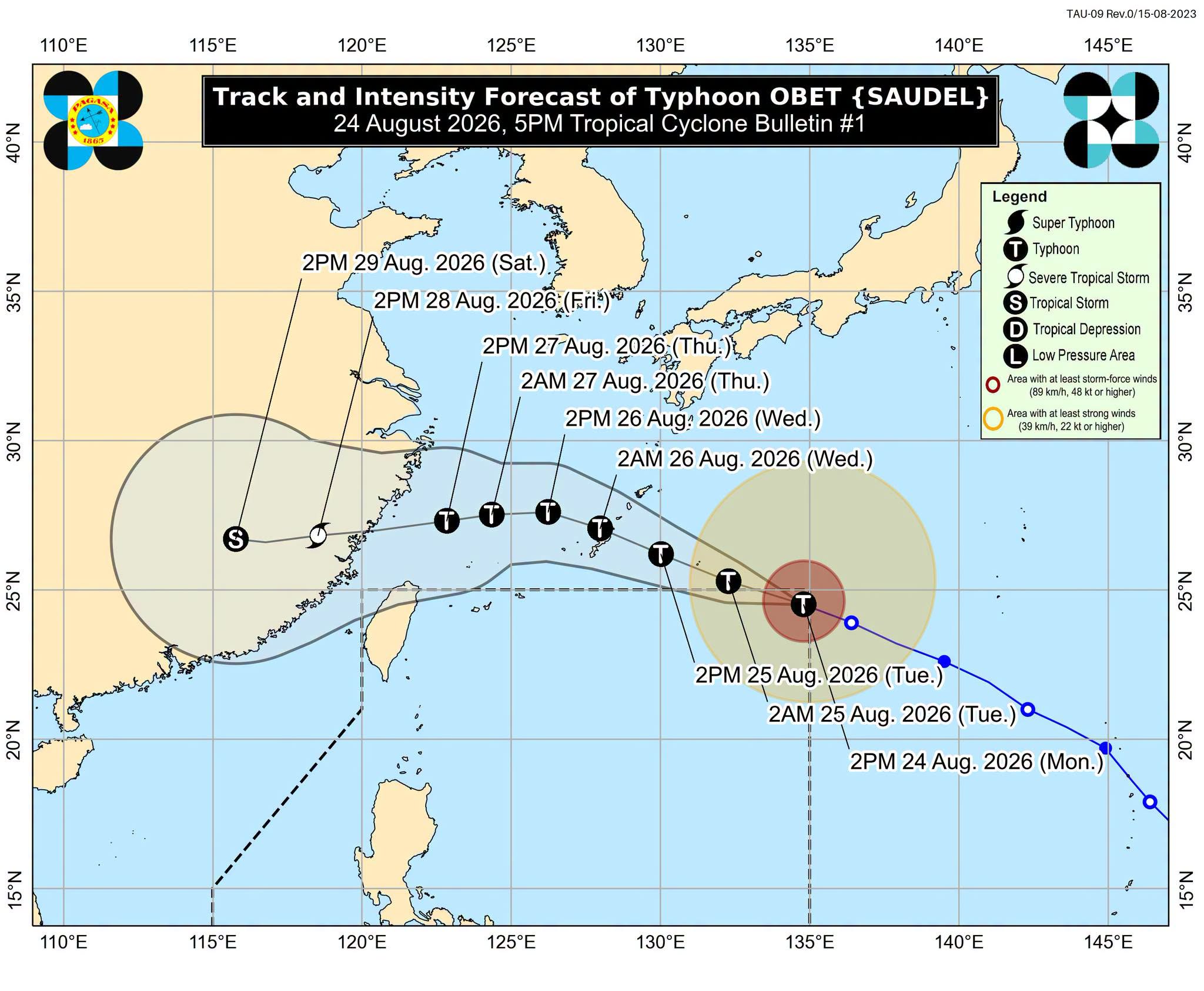
Typhoon Obet enters Philippine Area of Responsibility and may enhance the southwest monsoon. — Source: rappler
Severe Thunderstorm Hits Coastal Georgia
A Severe Thunderstorm Warning was issued for Chatham County, Georgia, with 60 mph wind gusts and reported damage to trees and power lines. Severe Thunderstorm Warning: Chatham, GA. At 346 PM EDT, severe thunderstorms were located along a line from over Fort Pulaski National Monument to near Wilmington Island, moving east at 20 mph. HAZARD...60 mph wind gusts. SOURCE...Law enforcement reported. At 345 PM, emergency officials reported damage to trees and powerlines with this line of storms. IMPACT...Expect damage to roofs, siding, and trees. Locations impacted include Tybee Island, Fort Pulaski National Monument, Wilmington Island, Skidaway Island, Savannah Beach, Wil. [1]
Flash Flooding Strikes Utah Burn Scar
A Flash Flood Warning was issued for the Babylon burn scar in central San Juan County, Utah, after thunderstorms produced heavy rain at rates of 1 to 3 inches per hour. Flash Flood Warning: San Juan, UT. FFWGJT The National Weather Service in Grand Junction has issued a Flash Flood Warning for The Babylon burn scar in Central San Juan County in southeastern Utah Until 430 PM MDT. At 134 PM MDT, Doppler radar indicated thunderstorms producing heavy rain over the Babylon Burn Scar over Dark Canyon. Between 0.5 and 0.8 inches of rain have fallen. The expected rainfall rate is 1 to 3 inches in 1 hour. Flash flooding is ongoing or expected to begin shortly. Excessive rainfall over. [2]
Typhoon Saudel Forecast to Skirt Northern Taiwan
Typhoon Saudel strengthened into a strong typhoon with sustained winds near the center reaching 183.6 kph and is forecast to pass closest to Taiwan on Thursday and Friday without making landfall, bringing storm-force winds and heavy rain to northern areas. Typhoon Saudel is expected to pass closest to Taiwan on Thursday and Friday as it moves over waters to the north, having already progressed to a strong typhoon, the Central Weather Administration (CWA) said today. The typhoon is not expected to make landfall in Taiwan, but its path remains unclear, it said. Saudel strengthened into a strong moderate typhoon this afternoon with sustained winds near the center reaching 183.6kph, although it is expected to weaken somewhat by Wednesday, it added. Storm-force winds are expected to affect northern Taiwan and Lienchiang County, while northern Taiwan and mountainous areas of central Taiwan should be on high alert for heavy or torrential rain from Thursday evening, the agency said. The typhoon remains in distant waters to the east of Taiwan, as it is expected to continue moving toward the Ryuku Islands through Wednesday as it gradually weakens, the CWA said. Meanwhile, eastern and southern Taiwan remain under a torrential or extremely heavy rain advisory in effect through tomorrow morning. Tropical Depression TD24 made landfall in China’s Fujian Province this afternoon, while Taiwan continues to experience the effects of a southwest monsoon and a low-pressure system, CWA forecaster Yeh Chih-chun (葉致均) said. As of 3pm today, Hualien and Taitung counties had recorded 367mm of accumulated rainfall each, with Pingtung County receiving 270mm and Yunlin County, Tainan and Kaohsiung each recording more than 200mm, he said. Heavy to extremely heavy rain in southern Taiwan, Taitung and mountainous areas of Hualien is expected to gradually ease after nightfall, he said. Looking to tomorrow, strong southeasterly winds are expected to affect the northern coast of Keelung and northeastern Taiwan in the morning, with localized heavy rain possible, he added. From Saturday to Monday next week, central and southern Taiwan would see occasional showers, while other areas would likely experience afternoon thunderstorms, he added. Those on the northern coast of Keelung, eastern Taiwan, the Hengchun Peninsula (恆春半島) and Lienchiang should prepare for long-period waves and rough coastal conditions, he said. [4]
Global Severe Weather Overview
Severe weather events are impacting multiple regions globally, with strong winds causing power outages and tree damage in South Africa and Lithuania, a severe thunderstorm triggering damage reports in Georgia, flash flooding over a burn scar in Utah, and Typhoon Saudel approaching Taiwan with strong winds and heavy rain. The eThekwini Municipality in South Africa deployed teams after strong winds caused widespread power outages from fallen trees and debris, affecting multiple communities with no reported injuries. A powerful storm in Lithuania left thousands without water, electricity, mobile signal or heating for days, prompting one town to declare a local state of emergency. A Severe Thunderstorm Warning was issued for Chatham County, Georgia, with 60 mph wind gusts and reported damage to trees and power lines. A Flash Flood Warning was issued for the Babylon burn scar in central San Juan County, Utah, after thunderstorms produced heavy rain at rates of 1 to 3 inches per hour. Typhoon Saudel strengthened into a strong typhoon with sustained winds near the center reaching 183.6 kph and is forecast to pass closest to Taiwan on Thursday and Friday without making landfall, bringing storm-force winds and heavy rain to northern areas. [1] [2] [3] [4] [5]
What to watch next: Typhoon Saudel is expected to pass closest to Taiwan on Thursday and Friday without making landfall, with storm-force winds affecting northern Taiwan and Lienchiang County and heavy rain alerts for northern and central mountainous areas.