
Severe Thunderstorms Hit North Carolina and Arkansas as Typhoon Saudel Approaches Taiwan
Severe thunderstorms struck parts of the southeastern United States while Typhoon Saudel approached Taiwan and heavy rain caused widespread flooding and disruption in Delhi-NCR and Lithuania.
US Southeast Thunderstorm Warnings
A severe thunderstorm with 60 mph wind gusts moved east at 25 mph near Clinton, North Carolina, threatening roof, siding and tree damage in Harrells. [1] The warning was issued at 730 AM EDT for Sampson County, where radar indicated the hazard. [1] Locations impacted include Harrells. [1] This storm carried the potential for damage to roofs, siding, and trees in the affected area. [1]
Another severe thunderstorm with ping-pong ball size hail and 60 mph winds moved southeast at 20 mph near Lamont, Arkansas, endangering people, animals, roofs, siding, windows, vehicles and trees in areas including Pine Bluff. [2] The warning was issued at 617 AM CDT for Cleveland County, where radar indicated the hazard. [2] Locations impacted include Pine Bluff, Lamont, Sulphur Springs, and Ain. [2] People and animals outdoors faced risk of injury from the hail and winds. [2] Hail damage was expected to roofs, siding, windows, and vehicles, while wind damage was expected to roofs, siding, and trees. [2] These two warnings highlighted active severe weather threats across separate parts of the southeastern United States on the same morning. [1][2]
Typhoon Saudel Nears Taiwan
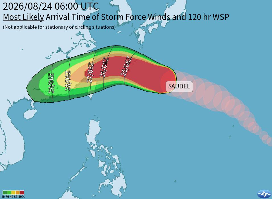
Typhoon Saudel strengthened to sustained winds of 183.6 kph and is forecast to pass closest to Taiwan on Thursday and Friday without making landfall, bringing storm-force winds to northern Taiwan and Lienchiang County plus heavy to torrential rain in northern and central mountainous areas. [3] The Central Weather Administration stated that the typhoon is not expected to make landfall in Taiwan, though its path remains unclear. [3] Saudel strengthened into a strong moderate typhoon with sustained winds near the center reaching 183.6 kph, although it is expected to weaken somewhat by Wednesday. [3] Storm-force winds are expected to affect northern Taiwan and Lienchiang County. [3] Northern Taiwan and mountainous areas of central Taiwan should be on high alert for heavy or torrential rain from Thursday evening. [3] The typhoon remains in distant waters to the east of Taiwan as it continues moving toward the Ryuku Islands through Wednesday while gradually weakening. [3]

Severe thunderstorms cause widespread power and water outages across Lithuanian towns. — Source: lrtlithuania
Eastern and southern Taiwan remain under a torrential or extremely heavy rain advisory in effect through tomorrow morning. [3] Tropical Depression TD24 made landfall in China’s Fujian Province, while Taiwan continues to experience the effects of a southwest monsoon and a low-pressure system. [3] As of 3pm, Hualien and Taitung counties had recorded 367 mm of accumulated rainfall each, with Pingtung County receiving 270 mm and Yunlin County, Tainan and Kaohsiung each recording more than 200 mm. [3] Heavy to extremely heavy rain in southern Taiwan, Taitung and mountainous areas of Hualien is expected to gradually ease after nightfall. [3] Looking ahead, strong southeasterly winds are expected to affect the northern coast of Keelung and northeastern Taiwan in the morning, with localized heavy rain possible. [3] From Saturday to Monday next week, central and southern Taiwan would see occasional showers, while other areas would likely experience afternoon thunderstorms. [3] Those on the northern coast of Keelung, eastern Taiwan, the Hengchun Peninsula and Lienchiang should prepare for long-period waves and rough coastal conditions. [3]
Lithuania Storm Recovery
A powerful weekend storm left thousands in Lithuanian towns without water, electricity, mobile signal or heating, prompting one town to declare a local state of emergency. [4] The storm tore through Lithuania over the weekend and left thousands of people without water, electricity, mobile signal or heating. [4] One town declared a local state of emergency as municipalities began assessing damage and clearing debris on Monday. [4] Recovery efforts focused on restoring essential services after the widespread outages caused by the powerful storm. [4]
Delhi-NCR Flooding and Travel Chaos
Heavy rain in Delhi-NCR on Monday led to severe waterlogging, traffic chaos, commuters wading through knee- and waist-deep water, and the diversion of 15 flights, with Chhatarpur recording 28 mm of rain in three hours. [5] Heavy rain lashed Delhi-NCR on Monday, leaving several roads waterlogged and traffic moving slowly across parts of the region. [5] Videos from Delhi, Gurgaon and Faridabad showed commuters wading through flooded roads, vehicles struggling to move and traffic piling up on key stretches. [5] Students waded through knee-deep water in Sangam Vihar. [5] Commuters waded through waist-deep water at Zakhira underpass, where a child navigated the flooded stretch while a mini-truck remained stuck and people dragged two-wheelers through the water. [5] A road turned into a river at Vatika Chowk, where people pushed a car through the waterlogged stretch. [5] Waterlogging occurred near New Ashok Nagar metro station, with commuters negotiating the inundated road. [5] Heavy rain and strong winds lashed Parliament Street, affecting visibility during the downpour. [5] Water accumulated on the roads around Shivaji Stadium and in Connaught Place. [5] Gurgaon traffic crawled on the Delhi-Jaipur Highway, with vehicles moving slowly through waterlogged stretches. [5] Rain lashed parts of Gurgaon while heavy traffic and slow vehicular movement occurred on National Highway 48. [5] Rain also lashed parts of Faridabad. [5] The heavy rain disrupted flight operations, with 15 Delhi-bound flights diverted, including two international flights, and 11 flights diverted to Jaipur. [5] The weather office had issued red and orange alerts for heavy to moderate rainfall accompanied by thunderstorms and winds of up to 40 kmph. [5] Heavy rain and thunderstorms were witnessed at isolated places across several parts of Delhi, including southeast Delhi, east Delhi, Shahdara, central Delhi, northeast Delhi, south Delhi, New Delhi, south west Delhi, west Delhi, north west Delhi and north Delhi. [5] Between 8.30am and 11.30am, Chhatarpur recorded the highest rainfall in Delhi at 28 mm, followed by Lodi Road at 24.6 mm and Pitampura at 18.5 mm. [5] Waterlogging was reported around New Ashok Nagar Metro Station, Burari, CR Park and Alaknanda, while parts of Gurgaon and Noida also reported inundation and traffic disruptions. [5]
Regional Weather Outlook
The typhoon remains in distant waters to the east of Taiwan as it continues moving toward the Ryuku Islands through Wednesday while gradually weakening. [3] Storm-force winds are expected to affect northern Taiwan and Lienchiang County from Thursday. [3] Heavy to extremely heavy rain in southern Taiwan, Taitung and mountainous areas of Hualien is expected to gradually ease after nightfall. [3] From Saturday to Monday next week, central and southern Taiwan would see occasional showers, while other areas would likely experience afternoon thunderstorms. [3] Those on the northern coast of Keelung, eastern Taiwan, the Hengchun Peninsula and Lienchiang should prepare for long-period waves and rough coastal conditions. [3]
What to watch next: Typhoon Saudel is forecast to pass closest to Taiwan on Thursday and Friday without making landfall while storm-force winds affect northern Taiwan and Lienchiang County and heavy or torrential rain threatens northern and central mountainous areas from Thursday evening.