
Severe Thunderstorm Warnings Issued for Indiana, Kansas, Kentucky and Florida
Active Severe Thunderstorm Warnings in the United States
The National Weather Service has issued multiple Severe Thunderstorm Warnings across parts of Indiana, Kansas, Kentucky and Florida Tuesday night, with storms producing wind gusts up to 60 mph and threats of damage to roofs, siding and trees. [1] A Severe Thunderstorm Warning covers eastern Vigo County, northeastern Sullivan County, Clay County, southwestern Owen County and southeastern Parke County in Indiana until 1130 PM EDT, with a storm near Brazil moving south at 45 mph. [1] Severe thunderstorms in Graham County, Kansas, produced 60 mph wind gusts and were nearly stationary along a line from near Norton to Edmond to Morland at 942 PM CDT. [2] In Boyle County, Kentucky, a line of severe thunderstorms with 60 mph gusts extended from near Richmond to areas near Stanford and Danville, moving southeast at 40 mph at 1043 PM EDT. [3] A severe thunderstorm near Stonemill Creek in Calhoun County, Florida, was moving southeast at 10 mph at 942 PM CDT with 60 mph wind gusts. [4] These warnings highlight radar-indicated hazards that include potential damage to roofs, siding and trees across the affected areas. [2]
Indiana Warning Details
A Severe Thunderstorm Warning covers eastern Vigo County in west central Indiana, northeastern Sullivan County in southwestern Indiana, Clay County in west central Indiana, southwestern Owen County in west central Indiana and southeastern Parke County in west central Indiana. [1] The warning remains in effect until 1130 PM EDT. [1] At 1049 PM EDT, a severe thunderstorm was located near Brazil, or 12 miles northeast of Terre Haute, moving south at 45 mph. [1] The National Weather Service in Indianapolis issued this alert for the listed counties in west central Indiana. [1] The storm's southward movement at 45 mph places the specified counties directly in its path through the evening hours. [1] Residents in eastern Vigo County, northeastern Sullivan County, Clay County, southwestern Owen County and southeastern Parke County should monitor updates as the thunderstorm progresses. [1]
Kansas Thunderstorms Remain Nearly Stationary
At 942 PM CDT, severe thunderstorms were located along a line extending from 5 miles southwest of Norton to near Edmond to 7 miles northeast of Morland, and are nearly stationary. [2] The hazard includes 60 mph wind gusts according to radar indicated sources. [2] Expect damage to roofs, siding and trees from these severe storms. [2] These severe storms will be near Norton and Edmond around 950 PM CDT. [2] Other locations impacted by these severe thunderstorms include Densmore, New Almelo and Calvert. [2] The nearly stationary nature of the line means communities along the path from near Norton to Edmond to Morland face prolonged exposure to the 60 mph wind gusts. [2] Radar indicated sources confirm the 60 mph wind gusts as the primary threat across Graham County. [2]
Kentucky Line of Storms Moving Southeast
At 1043 PM EDT, severe thunderstorms were located along a line extending from near Richmond to 9 miles north of Rockford to 6 miles northwest of Conway to near Stanford to 9 miles south of Danville, moving southeast at 40 mph. [3] The hazard includes 60 mph wind gusts with radar indicated sources. [3] Expect damage to roofs, siding and trees. [3] Locations impacted include Stanford, Lancaster, Berea, Crab Orchard, Boneyville, Duluth, Bighill, Ottenheim, Gilbert and Kingston. [3] The southeast movement at 40 mph carries the line of storms across Boyle County and surrounding areas. [3] Radar indicated sources support the 60 mph wind gusts that threaten the listed communities including Stanford, Lancaster and Berea. [3] The extent of the storm line from near Richmond through areas near Stanford and Danville affects multiple specific locations in its path. [3]
Florida Panhandle Storm Threat
At 942 PM CDT, a severe thunderstorm was located near Stonemill Creek, or 16 miles south of Blountstown, moving southeast at 10 mph. [4] The hazard includes 60 mph wind gusts from radar indicated sources. [4] Expect damage to roofs, siding and trees. [4] Locations impacted include Marysville, Scotts Ferry and Chipola Park. [4] The slow southeast movement at 10 mph keeps the thunderstorm near Stonemill Creek positioned to affect communities in its path. [4] Radar indicated sources confirm the 60 mph wind gusts as the main concern for the area around Calhoun County. [4] The severe thunderstorm near Stonemill Creek continues its gradual advance toward Marysville, Scotts Ferry and Chipola Park. [4]
Heavy Rain and Thunderstorm Risk in Finland
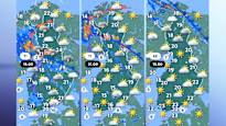
Sateita on tiistain aikana luvassa lähes koko maassa. [5] Tiistaina voimakkaat ukkoskuurot ovat mahdollisia osassa maata. [5] Maan etelä- ja keskiosissa lämpötilat jäävät päivän aikana 20 asteen alapuolelle. [5] Itä-Lapissa päästään lähemmäksi hellerajaa. [5] Iltapäivään tultaessa matalapaine liikkuu kohti pohjoista. [5] Tuolloin myös voimakkaat ukkoskuurot ovat mahdollisia osassa maata. [5] Ilmatieteen laitos antoi varhain tiistaina varoituksen rajusta ukonilmasta Lapin kaakkoisosiin ja Kainuuseen. [5] Sadevaroitukset ovat voimassa eri puolilla maata. [5] Iltaa kohden sää selkenee vähitellen lounaasta alkaen. [5] Lapissa matalapaine näkyy kuitenkin edelleen sateina ja ukkosina. [5] Sää muuttuu poutaisemmaksi ja lämpimämmäksi tiistain jälkeen. [5]
What to watch next includes the continued southeast movement of the Kentucky line at 40 mph and the gradual clearing from the southwest in Finland as the low-pressure system shifts north.