
Philippines Earthquake Raises Mindanao Seabed by Two Metres
A 7.8-magnitude Philippines earthquake struck southern Mindanao island on Monday, killing at least 61 people and leaving at least 40 missing while also raising the seabed by as much as two metres and harming marine life. [1] [2] Environment officials confirmed the coastal changes on Sunday. [2]
Overview of the Earthquake and Casualties
The 7.8-magnitude Philippines earthquake hit southern Mindanao island on Monday and produced immediate reports of widespread damage. [1] Disaster agency updates placed the death toll at at least 61 with at least 40 people still missing. [2] The tremor also displaced thousands of residents across the affected provinces. [3] Environment department statements released on Sunday tied the human toll directly to the same event that triggered seabed uplift. [1] Updated figures from the disaster agency reflected ongoing assessments of the Philippines earthquake’s impact. [2]
Coastal Uplift and Geological Changes
The Philippines earthquake caused coastal uplift by shifting the Cotabato Trench and pushing up coastlines of Sarangani and Davao Occidental provinces. [1] The uplift extended the shoreline by as much as 200 metres in places and exposed coral reefs and seagrass beds that had previously remained submerged. [2] Approximately two metres was the mapped uplift according to the Philippine Institute of Volcanology and Seismology. [1] Local residents first reported the geological phenomenon known as coastal uplift two days after the quake. [2] The shifting of the Cotabato Trench exposed the bottom of the sea that was originally submerged. [1]

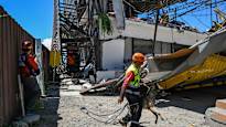
Rescue workers search rubble after a 7.8-magnitude earthquake struck Mindanao, Philippines, killing at least 61 people. — Source: channelnewsasia
Impact on Marine Life and Environment
Environment officials reported that exposed corals, seagrass, and marine organisms including reef fish, eels, clams and shells have begun dying off. [2] Images released by the department’s regional office showed a large swathe of exposed coral with dead fish and other aquatic life lying on top. [2] These exposed corals and seagrass beds had begun dying off alongside their resident organisms such as reef fishes, eels, clams, and shells. [2] The uplift phenomenon brought previously submerged marine life into direct exposure, accelerating the die-off process. [3] A team dispatched to the area found that long stretches of shoreline, coral reef and seagrass beds have been exposed. [2]
Official Response and Survey Efforts
A team from the environment department has been dispatched to survey the affected shoreline. [2] An official who spoke to AFP on Sunday said they could not yet say precisely how wide an area had been affected given the size of the area they needed to survey. [2] The precise width of the impacted area has not yet been determined. [2] Officials continue to monitor the situation following the Philippines earthquake and its geological after-effects. [1]
Philippines earthquake uplifted Mindanao seabed by up to two metres. — Source: ylenews
Seismic Context of the Cotabato Trench
The Cotabato Trench lies as close as 50 kilometres off the coast of southern Mindanao and is a site of frequent seismic activity. [1] This includes a swarm of thousands of mostly small earthquakes recorded in January. [2] The trench’s proximity helps explain why the Philippines earthquake produced such pronounced coastal uplift. [1] Frequent seismic events along the same feature have been documented over time, placing the Monday tremor within an established pattern. [2]
Local Reports and Initial Concerns
Local residents first reported the coastal uplift phenomenon two days after the quake. [1] Residents initially expressed concern about possible poisoning from fumes of decaying sea life. [2] They noticed the shoreline changes and raised alarms that prompted official visits to the area. [3] These early observations aligned with later findings from environment department teams that confirmed the extent of marine exposure. [2]
What to watch next: Environment department teams will continue surveys to determine the full width of the affected shoreline while monitoring ongoing die-off of exposed corals and seagrass beds.