Philippines Earthquake Death Toll Rises to 65 With 36 Still Missing
A magnitude-7.8 Philippines earthquake struck southern Mindanao on June 8, 2026, killing at least 65 people, leaving 36 missing, and causing a coastal uplift that raised the seabed by up to two meters and pulled the shoreline back by 200 meters. [1] The event and its aftershocks affected more than 735,000 people, with around 73,000 still in evacuation centers and damage reported to over 57,000 homes plus dozens of roads and bridges. [1]
Death Toll and Immediate Impact
The Philippines earthquake of magnitude 7.8 that struck southern Mindanao on June 8, 2026, produced a death toll that authorities raised to 65, with 36 people remaining unaccounted for. [2] The national disaster agency updated the casualty figures on Monday after the initial event, which also displaced thousands across the southern island. [4] More than 735,000 people felt the effects of the quake and its aftershocks, and approximately 73,000 individuals continued to shelter in evacuation centers according to the latest report from the National Disaster Risk Reduction and Management Council. [1] Damage extended to more than 57,000 homes along with dozens of roads and bridges and other regional infrastructure. [1] The main shock occurred at a depth of 55 kilometers south of Mindanao and generated a tsunami reaching up to 1.48 meters. [1] Local residents in affected areas such as Sarangani first noticed unusual changes to the coastline two days after the tremor. [1]
Coastal Uplift and Marine Damage

A magnitude 6.2 aftershock strikes southern Philippines one week after the deadly 7.8 earthquake. — Source: gdelt
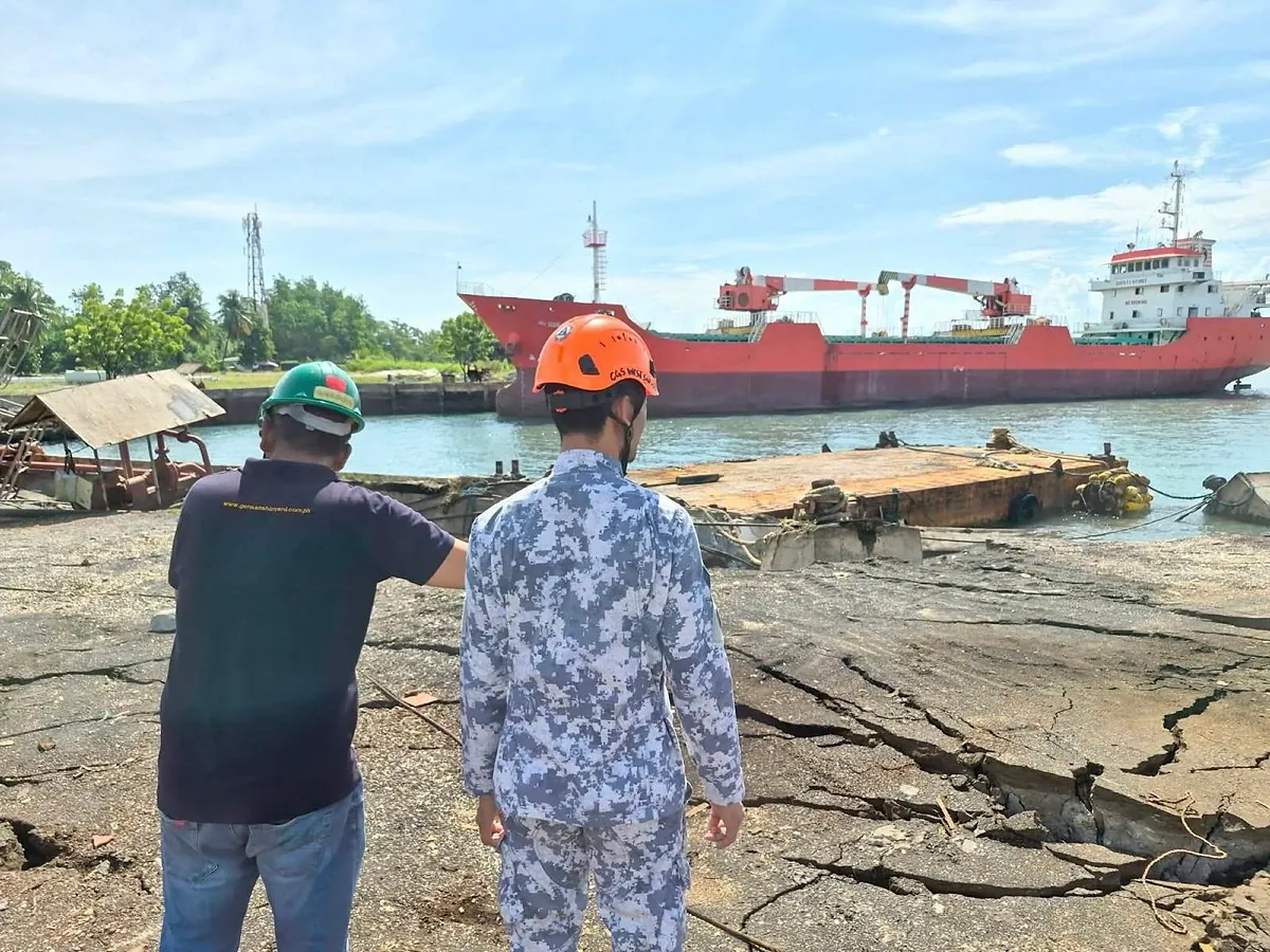
The coastal uplift triggered by the Philippines earthquake lifted the seabed by as much as two meters in parts of Sarangani and Davao Occidental, extending the shoreline by up to 200 meters in some locations. [5] This geological shift exposed long stretches of coral reefs and seagrass beds that had previously remained submerged, leading to the death of resident marine organisms including reef fish, eels, clams, and shells. [5] The Philippine Institute of Volcanology and Seismology confirmed through surveys conducted by Saturday that the mapped uplift reached approximately two meters at the affected sites. [1] Images released by the environment department’s regional office showed large areas of exposed coral with dead aquatic life lying on the surface. [5] Residents initially reported the phenomenon out of concern that decaying sea life might release fumes capable of causing poisoning. [5] The environment department noted that the exposed corals and seagrass beds had begun dying off alongside their associated organisms. [5] A team dispatched to the area documented the extent of the shoreline, coral reef, and seagrass exposure, although officials stated they could not yet determine the precise width of the impacted zone given the scale of the survey required. [5]
Aftershock Activity
A magnitude-6.2 aftershock struck off the coast of Mindanao on Monday at 5:18 pm local time at a depth of 112 kilometers. [2] The United States Geological Survey recorded the event one week after the main Philippines earthquake, and no tsunami warning was issued. [4] No immediate reports of injuries or damage emerged from the aftershock, which provincial disaster officials described as moderate. [2] Monitoring priorities shifted to watching the coastline for any signs that water had receded, an indicator of a possible tsunami, although none were observed. [2] In total, more than 5,860 aftershocks ranging from magnitude 1.2 to 6.4 followed the June 8 main shock. [1] A series of powerful aftershocks occurred roughly two hours after the initial tremor, including one of magnitude 6.5. [2]
Geological Context
The Philippines earthquake occurred in a region situated on the Pacific Ring of Fire, an arc of intense seismic activity that stretches from Japan through Southeast Asia and across the Pacific basin. [2] The Cotabato Trench, located as close as 50 kilometers off the coast of southern Mindanao, serves as the site of frequent seismic activity. [5] This trench experienced a swarm of thousands of mostly small earthquakes in January. [5] A shifting of the Cotabato Trench pushed upward part of the coastlines of Sarangani and Davao Occidental provinces, exposing the previously submerged seabed. [5] Earthquakes remain a near-daily occurrence in the Philippines because of its position on the Ring of Fire. [4] The same trench and surrounding faults have produced other notable events, such as a pair of earthquakes of magnitudes 7.4 and 6.7 that struck eastern Mindanao in October and killed at least eight people. [4]
Official Response and Ongoing Monitoring
The Philippine Institute of Volcanology and Seismology conducted surveys that confirmed the coastal uplift measurements following the Philippines earthquake. [1] The environment department dispatched teams to assess the marine damage and released photographs documenting exposed coral and dead aquatic life. [5] The National Disaster Risk Reduction and Management Council compiled and released updated casualty figures, including the toll of 65 dead and 36 missing, along with data on the number of people in evacuation centers and homes damaged. [1] Local disaster offices, such as the Davao Oriental provincial disaster office, monitored coastal areas after the magnitude-6.2 aftershock for any indications of receding water. [2] Officials emphasized continued vigilance along the shoreline in the days after the aftershock while noting that no tsunami signs had appeared. [2] The environment department stated that residents had first alerted authorities to the coastal changes out of concern for potential health effects from decaying marine organisms. [5]
What to watch next: Authorities will continue monitoring the coast for any signs of receding water after aftershocks, while teams survey the full extent of exposed marine areas.