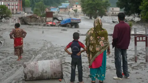
Nepal natural disasters: flood from glacier collapse kills 165 and leaves 1500 missing
A glacier collapse on Langtang Lirung triggered a massive flash flood and mudslide along the Nepal-China border on August 26 2026 that destroyed the Gyirong Port border crossing, wiped out villages, killed at least 165 people and left nearly 1500 others including hundreds of foreigners missing amid these natural disasters. [3] The flood followed a large ice-rock avalanche that produced seismic waves equivalent to a magnitude-5.2 earthquake and scoured valley walls more than 100 feet above the riverbank. [5] Gyirong Port, a key Belt and Road trade hub handling $600 million in annual trade, was completely erased along with at least six major hydropower plants and roads in the Trishuli River valley. [2]
Disaster strikes Nepal-China border
The event began with the collapse of a glacier and a massive rock-ice avalanche on the north shoulder of Langtang Lirung on the Nepali side of the border. [2] This sent a wall of mud and rock into the Lhende Khola river, producing a multi-stage hazard chain that crossed borders and altered river channels more than 100 km downstream near the Indian border. [3] Nepal reports at least 165 dead with nearly 1,500 people listed as missing, including hundreds of foreign nationals such as 65 American citizens and at least 800 foreigners overall. [3] Among the destroyed infrastructure was Gyirong Port, which had previously been closed for the second half of 2025 due to damage from an earlier flood on the Trishuli River. [2]
Eyewitness accounts from Bidur and Timure
Survivors from Nepal’s flood-ravaged districts were airlifted to safety on Thursday as helicopters landed every few minutes on a football field inside the town’s military cantonment in Bidur, whipping up clouds of dust. [1] A few walked alone with faces frozen in shock while others were transported on stretchers or gently supported by the shoulders. [1] Among the survivors was customs agent Omkar Joshi, who spent the previous night stranded on a hilltop in the border town of Timure before being rescued. [1]
Scientific explanation of the trigger
Initial assessments based on seismic and satellite data as well as videos of the event indicate that a very large section of a glacier detached and collapsed after the bedrock below it gave way. [5] That in turn caused seismic waves equivalent to a 5.2 magnitude earthquake according to the U.S. Geological Survey. [5] Ice from the glacier and rockfall may then have blocked the Lhende Khola river, causing water to quickly accumulate and ultimately surge downstream. [5] Scientists confirmed there was a large ice avalanche, probably a mixture of ice and rock, which detached and then became fluid and transformed into this devastating flood. [5] The exact cause is still being analyzed but the disaster probably began with a massive ice-rock avalanche on the northern slopes of Nepal’s Langtang Lirung peak into the Lhende Khola river on the Tibetan side. [3]
Climate change connection
Climate change is leading to conditions that can destabilize high-mountain rock and ice, strengthening prospects for disasters such as this week’s Himalayan flood. [3] “Climate change is generating conditions that can destabilize high-mountain rock and ice,” said Simon Cox, chief scientist at the Mountains to Sea Program at Earth Sciences New Zealand. [3] Warming can reduce ice support on steep slopes, boost meltwater, and change patterns of freezing, thawing and rainfall, which can weaken mountainsides and make large collapses more likely. [3] Rising mountain temperatures make the cryosphere far more vulnerable than in the past, said Farooq Azam, senior cryosphere specialist at ICIMOD. [3] The long-term trend appears stark, with the United Nations saying in 2023 that global warming caused Nepal’s snow-capped mountains to lose close to one-third of their ice cover in just over 30 years. [3]
Scale of physical destruction
Satellite analysis shows roughly 20 square kilometres of land affected by mudflow and rockflow within a 230-square-kilometre zone in Rasuwa district. [4] Post-accident imagery shows that the resulting flood of water and rock scoured the vegetation off the valley walls about 100 feet or more above the usual height of the riverbank. [2] At least six major hydropower plants and infrastructure at the Gyirong Port trade hub were damaged. [3] Some of the debris from the mudflow has piled up into a natural dam a few miles upstream of the Gyirong border crossing and is turning the location into a lake. [2] High-resolution satellite imagery shows an undeveloped landscape virtually free of roads, buildings or other signs of human habitation at the former port site. [2]
Ongoing rescue and risks
Rescue operations in Nuwakot and Rasuwa districts involved helicopters airlifting survivors including customs agent Omkar Joshi from hilltops and a football field landing zone in Bidur amid ongoing rainfall that threatens to burst a natural debris dam. [1] Relief operations are under way to hunt for survivors and bring aid to villages that were cut off by the torrent of water which wiped away the rudimentary roads that wind up the Trishuli River valley. [2] That dam will continue to fill for days because of ongoing rainfall according to Chinese authorities and could burst and cause more flash flooding downstream. [2] The area is a popular tourism destination and among the missing are hundreds of foreign nationals. [2]
What to watch next: The natural dam upstream of Gyirong continues to fill with ongoing rainfall and could burst, causing additional downstream flooding while relief teams search for survivors cut off by the torrent. [2]