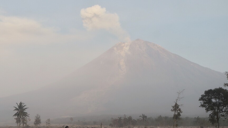

Natural Disasters Prompt Heightened Alerts as Mount Semeru Erupts Three Times While Japan Raises Tokachidake Alert to Level 3
Multiple volcanoes across Indonesia, Japan and mud volcano sites in Ukraine showed increased activity or raised alerts in recent days, including Mount Semeru’s three eruptions, elevated seismic activity at Mount Tokachidake prompting a Level 3 alert, and ongoing monitoring of mud volcanoes linked to seismic triggers amid natural disasters. Indonesia’s Mount Semeru erupted three times, sending ash 1,000 meters above the summit while remaining at Level III alert. [1] Japan’s Meteorological Agency raised the alert for Mount Tokachidake in Hokkaido to Level 3 for the first time since 2008 due to intensified activity, increased large volcanic earthquakes since mid-August, crustal deformation since March and higher sulfur dioxide emissions since April. [4]
Current Volcanic Activity in Indonesia Amid Natural Disasters
Indonesia’s Mount Semeru erupted three times, sending ash 1,000 meters above the summit while remaining at Level III alert. [1] Five Indonesian volcanoes including Anak Krakatau, Lewotobi Laki-laki, Merapi, Semeru and Sinabung are under siaga (alert) status with recorded earthquakes, tremors, lava avalanches and ash emissions. [3] On 13 September, Mount Anak Krakatau was covered by fog with no crater smoke observed under cloudy weather and weak northwest winds at temperatures of 26.4-26.7°C and humidity 84-87 percent, recording two low-frequency earthquakes and one continuous tremor while authorities recommended staying outside a 3 km radius from the active crater. [3] Mount Lewotobi Laki-laki appeared clear to foggy with thin white crater smoke rising 50 meters, under clear to cloudy skies and weak west to northwest winds at 23-25°C, recording 11 deep volcanic earthquakes and 12 distant tectonic earthquakes, with a 5 km exclusion zone from the eruption center and warnings for lahar floods in rivers such as Dulipali, Padang Pasir, Nobo, Nurabelen, Klatanlo, Hokeng jaya, Boru and Nawakote during heavy rain plus mask use during ashfall. [3] Mount Merapi was visible with no crater smoke under clear skies and calm west winds at 16.1-17.8°C and humidity 76-79 percent, recording 15 avalanche earthquakes and 14 hybrid or B-phase earthquakes, with potential hazards of lava avalanches and pyroclastic flows up to 5 km in the south-southwest sector along rivers Boyong, Bedog, Krasak and Bebeng and up to 7 km in some cases, plus 3 km in the southeast along Woro and 5 km along Gendol, and explosive ejecta possibly reaching 3 km. [3] Mount Semeru was clear to foggy with no visible crater smoke under clear to overcast skies and weak southwest winds at 17-19°C, recording 26 eruption earthquakes, 7 avalanche earthquakes, 5 emission earthquakes, 15 harmonic earthquakes and 3 distant tectonic earthquakes, with observed avalanches traveling 500-800 meters southeast, and authorities barring all activity along Besuk Kobokan up to 13 km from the peak plus a 500-meter riverbank buffer extending to 17 km for hot clouds and lahars, plus a 5 km crater radius ban due to rock ejecta. [3] Mount Sinabung was clear to foggy with moderate to thick white crater smoke rising 300-500 meters under clear to cloudy skies and weak to moderate east to west winds at 15-18°C, recording one distant tectonic earthquake, with bans on activity in relocated villages and within a 3 km radial zone plus sectoral restrictions of 5 km south-southeast, 4 km east-northeast and 4 km west, plus mask use during ashfall and lahar vigilance along headwater rivers. [3]
Japan Raises Alert Level for Mount Tokachidake
Japan’s Meteorological Agency raised the eruption alert level for Mount Tokachidake in Hokkaido to Level 3 on Saturday morning, banning entry to the 2,077-meter mountain. [4] This is the first time that Level 3 has been issued for the mountain since the alert system was introduced in 2008. [4] Level 2 restricts access to areas around the craters. [4] Volcanic activity has intensified, raising the possibility of an eruption, the agency said, warning of large volcanic rocks within about 3 kilometers of the crater. [4] The mountain straddles the city of Furano and the towns of Biei, Kamifurano, Minamifurano and Shintoku. [4] The Kamifurano town government has issued an evacuation order for the Fukiage Onsen area and advised elderly and other vulnerable residents in the Tokachidake Onsen area to evacuate. [4] The number of large volcanic earthquakes near Mount Tokachidake has increased since Aug. 17, with the strongest quake occurring around 8:20 a.m. Saturday. [4] Since March, crustal deformation indicating expansion at a moderately deep level near the mountain has continued, while emissions of volcanic gas, or sulfur dioxide, have increased since April. [4] The crater where an eruption could occur is one of the craters from which an eruption occurred in 1962 and is known as the “62-2 crater.” [4] A very small eruption occurred on July 22 this year, the first eruption at the volcano in 22 years, followed by further minor eruptions on Aug. 5 and 6. [4] In the eruption in May 1926, a large-scale mudflow triggered by snowmelt occurred, leaving 144 people dead or missing. [4] A 1926 eruption at Tokachidake triggered a large-scale mudflow that killed or left missing 144 people. [4]
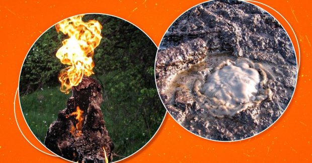
Mud volcanoes in Ukraine are monitored for seismic activity amid regional volcanic alerts. — Source: gdelt
Mud Volcanoes in Ukraine
Ukraine has only extinct magmatic volcanoes but more than 100 mud volcanoes, many active on the Kerch Peninsula, that release mud, water and gas rather than lava and are often triggered by seismic activity from distant earthquakes. [2] In Ukraine there are both ancient extinct volcanoes and mud volcanic formations that can still show activity today. [2] The youngest extinct volcanoes are located in Transcarpathia in the area of the Volcanic Ridge stretching about 100 kilometers from Uzhhorod to Khust, with Kara-dag also known in Crimea and individual volcanic structures on the Ukrainian Shield as the oldest. [2] A volcano is considered a natural formation that currently or in the past erupted lava or other products of volcanic activity, with the key link being magmatic processes rather than shape or appearance. [2] Mud volcanoes, from which mud and gas emerge to the surface, do not formally belong to real volcanoes because they are not connected with magmatic processes and high temperatures. [2] Mud volcanoes form in the sedimentary shell of the Earth while real volcanoes are associated with magmatic processes. [2] If during an eruption of an ordinary volcano lava comes to the surface with temperatures that can exceed 1000 °C, then mud volcanoes are significantly colder. [2] For the formation of a mud volcano, a powerful thickness of plastic, mainly clayey rocks containing water and gas is necessary, creating increased pressure under which rocks can move to the surface through weakened areas of the earth’s crust. [2] Mud volcanic territories are usually associated with oil and gas regions because gas enters water-saturated plastic rocks and creates anomalous pressure, making mud volcanism one of the search criteria for oil and gas objects. [2] More than 100 mud volcanoes may exist in Ukraine when counting both active and those that have ceased activity. [2] Separate active mud volcanoes are located on the Kerch Peninsula and on the opposite bank of the Kerch Strait in Krasnodar Krai. [2] After earthquakes in the area of Romania and the Carpathians, the activity of mud volcanoes intensified as underground waves caused movement of rocks and provoked emissions of water, gas and mud. [2] Sometimes such eruptions were so powerful that they could damage nearby buildings, with volumes of mud masses reaching millions of tons. [2] During activation, hissing and crackling are first heard, then the volcano ejects clay, pieces of stones, water and gas, with the active phase lasting one or two days before gradually subsiding. [2] Processes related to mud volcanism occur at depths up to 12–13 kilometers. [2] Starunia in Ivano-Frankivsk region is also of sedimentary origin and is a mud volcano, with millions of years ago a sea basin on the territory of modern Ivano-Frankivsk region where clays, sands, calcareous deposits and organic remains accumulated, later forming the basis for oil and gas that under pressure move to weakened areas of the earth’s crust, carrying water and mud to the surface. [2]
Hazards and Official Recommendations
Indonesia’s Mount Semeru erupted three times, sending ash 1,000 meters above the summit while remaining at Level III alert. [1] Authorities recommended that communities, visitors and climbers not approach Mount Anak Krakatau or conduct activities within a 3 km radius of the active crater. [3] For Mount Lewotobi Laki-laki, communities were told not to conduct any activities within a 5 km radius from the eruption center, to remain calm and follow local government directions, to be wary of lahar floods in specified rivers during heavy rain, and to wear masks during ashfall while local governments coordinate with observation posts. [3] For Mount Merapi, communities were advised not to conduct activities in hazard areas, to anticipate volcanic ash disturbances and lahar dangers especially during rain around the volcano, to stop mining in river channels heading from Merapi in KRB III, and for tourism operators to avoid hazard areas and the crater opening within 5 km. [3] For Mount Semeru, no activities were allowed in the southeast sector along Besuk Kobokan up to 13 km from the peak, outside that distance no activities within 500 meters of the riverbank along Besuk Kobokan due to potential expansion of hot clouds and lahars up to 17 km, and no activities within a 5 km radius from the crater or peak due to risk of glowing rock ejecta, while remaining vigilant for hot avalanches, lava avalanches and lahars along rivers and valleys heading from the peak especially Besuk Kobokan, Besuk Bang, Besuk Kembar and Besuk Sat as well as potential lahars in small tributary rivers. [3] For Mount Sinabung, communities and visitors were told not to conduct activities in already relocated villages or within a 3 km radial radius from the peak plus sectoral radii of 5 km south-southeast, 4 km east-northeast and 4 km west, to wear masks if ash falls when leaving home, to secure clean water facilities and clean thick volcanic ash from house roofs to prevent collapse, and to remain vigilant against lahar dangers for those living near rivers heading from Mount Sinabung. [3] Japan’s Meteorological Agency warned of large volcanic rocks within about 3 kilometers of the crater at Mount Tokachidake and issued an evacuation order for the Fukiage Onsen area with advice for elderly and vulnerable residents in the Tokachidake Onsen area to evacuate. [4]
Geological Context and Triggers
Ukraine has only extinct magmatic volcanoes but more than 100 mud volcanoes, many active on the Kerch Peninsula, that release mud, water and gas rather than lava and are often triggered by seismic activity from distant earthquakes. [2] Mud volcanoes form through sedimentary processes and pressure from gas and water, with their connection to past magmatic activity and how earthquakes can provoke eruptions. [2] In scientific literature the concept of a “mud volcano” is considered unsuccessful because it is not actually a volcanic process connected with magmatic activity. [2] Mud volcanoes often have the appearance of depressions and sinkholes rather than cones because during eruptions volcanoes eject millions of tons of substance, creating a mass deficit in the depths and gradual subsidence of the surface territory. [2] Mud volcanism is often viewed as a consequence of more ancient magmatic processes in these territories that could have influenced the formation of corresponding geological conditions. [2] The activity of mud volcanoes depends primarily on seismic processes, with no seasonal attachment such as winter awakening on the Kerch Peninsula. [2] During powerful eruptions mud volcanoes can eject so much material that islands form right in the middle of the sea. [2] When anomalous pressure decreases, activity ceases. [2]
What to watch next includes continued monitoring of seismic triggers that can provoke mud volcano emissions on the Kerch Peninsula and further minor eruptions or deformation changes at Mount Tokachidake following the Level 3 alert.







