
Magnitude 5.2 Earthquake Strikes Off Philippines as Global Tremors Continue
Multiple earthquakes today struck various global locations in the past day, including a magnitude 5.2 event off the Philippines, a 3.6 quake near Falls City, Texas, a 3.5 tremor in Peru's Junín region, a 3.1 quake in Colombia's Chocó department, and a 2.9 event in Alaska.
Recent Global Earthquake Activity
A magnitude 5.2 earthquake occurred 35 km SE of Sarangani, Philippines at a depth of 120.8 km. [5] A magnitude 3.6 earthquake struck 12 km SW of Falls City, Texas at a depth of 8.6 km. [1] A magnitude 3.5 earthquake hit 18 km south of Chupaca in Peru's Junín region at a shallow depth of 9 km and was felt with intensity II-III on the Mercalli scale. [4] A magnitude 3.1 earthquake was recorded in Colombia's Chocó department near San Juan (Docordó) at a depth of 48 km, with coordinates latitude 4.30° and longitude -76.73°. [2] A magnitude 2.9 earthquake occurred 59 km SW of Pilot Point, Alaska at a depth of 143.4 km. [3] Colombia's recent seismic activity follows a larger magnitude 7.4 earthquake on August 10 that affected several cities, and more than 50 tremors have been noted near the Puracé volcano. [2]
Philippines: Magnitude 5.2 Quake
A magnitude 5.2 earthquake occurred 35 km SE of Sarangani, Philippines at a depth of 120.8 km. [5] This event stands as the strongest among the cluster reported across multiple countries in the past day. [5] The precise location and depth data come directly from official seismic recording. [5] Such measurements help establish the scale of activity in the region without immediate reports of surface effects tied to the depth. [5]
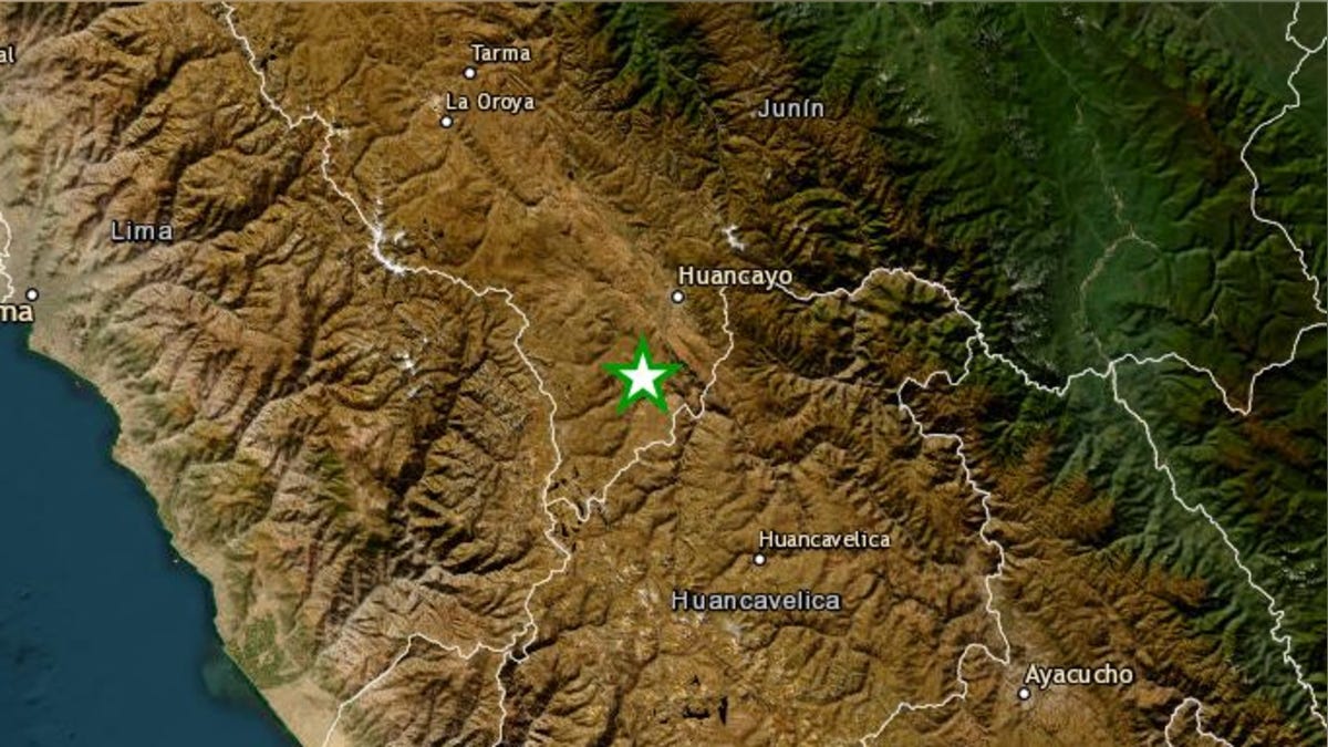
A magnitude 3.5 earthquake struck 18 km south of Chupaca in Peru's Junín region. — Source: gdelt
Texas and Alaska Events
A magnitude 3.6 earthquake struck 12 km SW of Falls City, Texas at a depth of 8.6 km. [1] A magnitude 2.9 earthquake occurred 59 km SW of Pilot Point, Alaska at a depth of 143.4 km. [3] Both events were recorded by the same monitoring network that tracks activity across the United States. [1] [3] The Texas quake registered at a relatively shallow depth while the Alaska event took place at a much greater depth. [1] [3] These details allow comparison of how depth influences potential surface perception in different parts of the country. [1] [3]
Peru Junín Tremor and Seismic Concerns
A magnitude 3.5 earthquake hit 18 km south of Chupaca in Peru's Junín region at a shallow depth of 9 km and was felt with intensity II-III on the Mercalli scale. [4] The epicenter was located at latitude -12.22 and longitude -75.31 according to the report. [4] Authorities have not reported any material damage or victims from this phenomenon. [4] A seismologist noted that the central coast of Peru has accumulated seismic energy since 1746 and that recent events have released only about 20 percent of that energy, pointing to the possibility of a future event exceeding magnitude 8.0. [4] The expert added that such an event could occur at sea with a shallow depth and be followed by a tsunami. [4]
Colombia Continues to Experience Seismic Activity
A magnitude 3.1 earthquake was recorded in Colombia's Chocó department near San Juan (Docordó) at a depth of 48 km, with coordinates latitude 4.30° and longitude -76.73°. [2] The event took place at 3:48 a.m. on the first of September and was felt by some residents while others did not perceive it. [2] Colombia continues registering seismic activity in different zones following the magnitude 7.4 earthquake on August 10 that affected cities including Buenaventura, Manizales, Pereira and Cali as well as areas of Chocó. [2] More than 50 tremors have been noted in the area of the Puracé volcano. [2] The Servicio Geológico Colombiano maintains constant monitoring and updates reports with details on magnitude, depth, time and location for each detected movement. [2]
Official Monitoring and Public Guidance
Agencies including the USGS, SGC and IGP provide precise data on the recorded events. [1] [2] [3] [4] [5] In situations involving seismic activity, authorities recommend consulting only information released by official organizations and avoiding the sharing of unverified versions that could generate confusion or alarm. [2] The Servicio Geológico Colombiano continues vigilance due to the country's geological conditions and the interaction of tectonic plates. [2] The Instituto Geofísico del Perú similarly supplies reports that include intensity assessments on the Mercalli scale. [4] These verified sources form the basis for understanding the cluster of earthquakes today without reliance on unofficial channels. [2] [4]
What to watch next: Continued updates from the Servicio Geológico Colombiano on activity near the Puracé volcano and any further reports from the Instituto Geofísico del Perú regarding the central coast energy accumulation noted by the seismologist.







