
Hurricane Tracker Shows Typhoon Champi Approaching Taiwan With Peak Impacts Forecast for Friday
Hurricane tracker data indicate that Typhoon Champi is forecast to approach Taiwan this week with peak impacts expected Friday and Saturday, prompting potential sea and land warnings from the Central Weather Administration.
Current Position and Forecast Path of Typhoon Champi
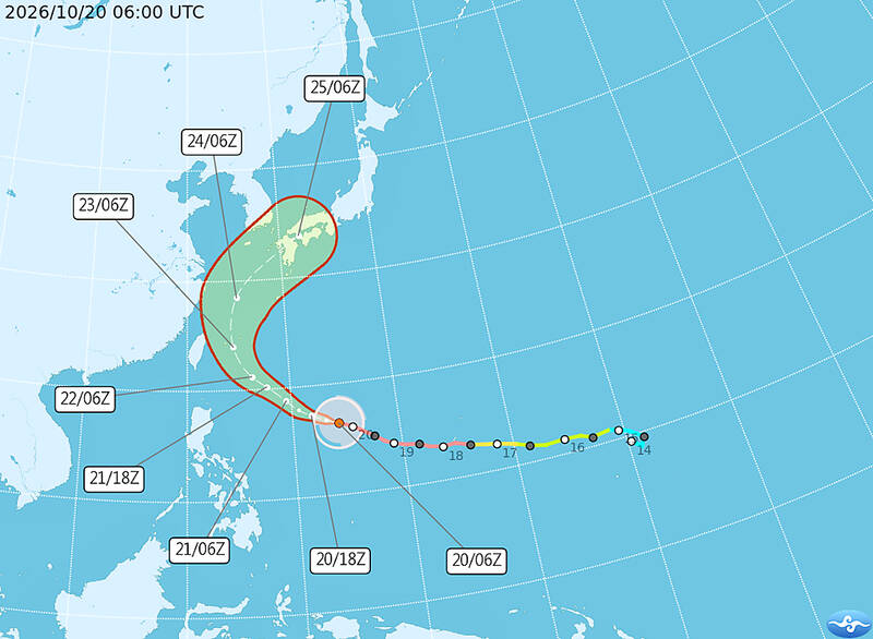
As of yesterday afternoon, Champi was located 1,536km east-southeast of Taiwan’s Oluanpi, with maximum sustained winds of 198kph, moving west-northwest at 23kph. [1] The storm is expected to strengthen over the next 24 hours before weakening slightly near cooler waters, then turn north on Thursday, with its exact path determining proximity to northern Taiwan. [1] As of 8am today, Champi was about 1,680km east-southeast of Oluanpi, moving west-northwest at 25kph. [5] The typhoon had maximum sustained winds of 198kph, with gusts reaching 245kph, and a storm radius of 250km. [5] Champi remained an intense typhoon and was expected to reach peak strength today or tomorrow. [5] Champi is expected to turn north tomorrow, with the angle of the turn determining its proximity to Taiwan. [1] Regardless of its exact path, Champi is expected to be closest to Taiwan from Friday to Saturday morning. [1] Typhoon Champi is forecast to begin turning northward on Thursday, moving away from Taiwan, but its impact on the nation is expected to be most pronounced on Friday and Saturday. [5] The typhoon is expected to move away from Taiwan on Sunday or Monday next week. [5]
Taiwan Warning Timeline
A sea warning may be issued tonight or tomorrow night, and a land warning for northern Taiwan, Yilan and Hualien is possible tomorrow night depending on the typhoon’s trajectory. [1] A sea warning for Typhoon Champi might be issued tonight, while the storm’s trajectory would determine whether a land warning is to be issued tomorrow night, the Central Weather Administration said yesterday. [1] Based on the typhoon's projected path, the CWA could issue a sea warning late tomorrow night or on Thursday morning. [5] A land warning could also be issued on Thursday night. [5] While some international tracking models predict the typhoon would move close to Taiwan, the probability of it veering to the northeast has increased compared with earlier forecasts. [1] The CWA bases its warnings on the models with the smallest margin of error in recent predictions. [1] Hurricane tracker information continues to inform these decisions as forecasters monitor the storm’s northward turn.
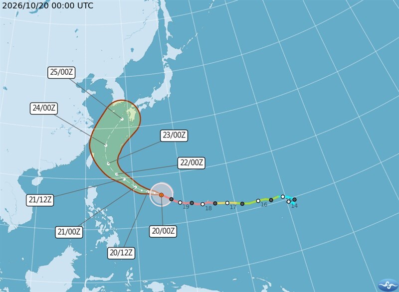
Typhoon Champi forecast to bring peak impacts to Taiwan on Friday and Saturday. — Source: taipei-times
Expected Rainfall and Wind Impacts
Heavy or extremely heavy rainfall is forecast for northern and eastern Taiwan on Friday, with strong winds and waves up to 6m possible off the east coast, Orchid Island and Green Island. [1] From today, a strengthening northeast monsoon is to bring rain to northern and eastern regions, with heavy downpours likely in Yilan and mountainous areas of greater Taipei. [1] Precipitation is to intensify tomorrow as the typhoon approaches, peaking on Friday, when rain is expected nationwide. [1] Northern and eastern areas could have heavy or extremely heavy rainfall. [1] Rain is to ease by Saturday afternoon as the storm departs. [1] Strong winds and large waves are expected, with waves off the east coast, Orchid Island and Green Island potentially reaching 6m tomorrow. [1] Rain is expected across Taiwan on Friday and Saturday, with heavy or extremely heavy rain possible in the north, as well as in Yilan and Hualien counties in the east. [5] The typhoon’s effects in terms of wind and rain were expected to be strongest on Friday and Saturday. [5] Unseasonably warm temperatures of 31°C to 34°C today are forecast to give way to highs of 23°C to 25°C in the north and 28°C in central and southern parts of the country tomorrow before rebounding on Sunday. [5] Rain is likely to be largely confined to Taoyuan and areas north of the city, as well as eastern Taiwan, after the storm moves away. [5]
Ongoing Flood Warnings in the United States
Separate flood warnings remain in effect for the St. Johns River in Florida and the Satilla River in Georgia due to persistent northeast winds and minor to moderate flooding. [2] The Flood Warning continues for the St Johns River Near Astor affecting Volusia and Lake Counties. [2] Persistent northeast winds have caused river levels on the St Johns at Astor to rise into Moderate Flood Stage. [2] The river is forecast to climb slowly through Moderate Flood Stage through the end of this week. [2] There is potential for levels to approach Major Flood Stage next week after northeasterly winds increase again. [2] The Flood Warning continues for the Satilla River At Atkinson affecting Brantley County. [4] Minor flooding is occurring and minor flooding is forecast. [4] The warning remains in effect until further notice. [4] At 13.0 feet, impacts include effects on Warners Landing, Louis Landing and secondary roads around KOA campgrounds. [4] The next statement will be issued Wednesday morning at 845 AM EDT. [4]
Broader Context of Severe Weather
Accelerating warming pushes vital ecosystems towards point of no return, scientist warns. [3] This background underscores ongoing global severe weather patterns as Typhoon Champi approaches Taiwan and separate river conditions persist in the United States.
What to watch next: The typhoon is expected to move away from Taiwan on Sunday or Monday next week, with rain likely to be largely confined to Taoyuan and areas north of the city, as well as eastern Taiwan.