
Hurricane Tracker Shows Typhoon Champi Approaching Taiwan With 191 kph Winds
The hurricane tracker shows Typhoon Champi approaching Taiwan this week with a possible sea warning as early as Wednesday night, while Hurricane Trudy is lashing Mexico's Pacific coast and a record El Niño event is expected to bring wetter conditions to Cyprus and influence global weather. [1] [3]
Typhoon Champi Nears Taiwan
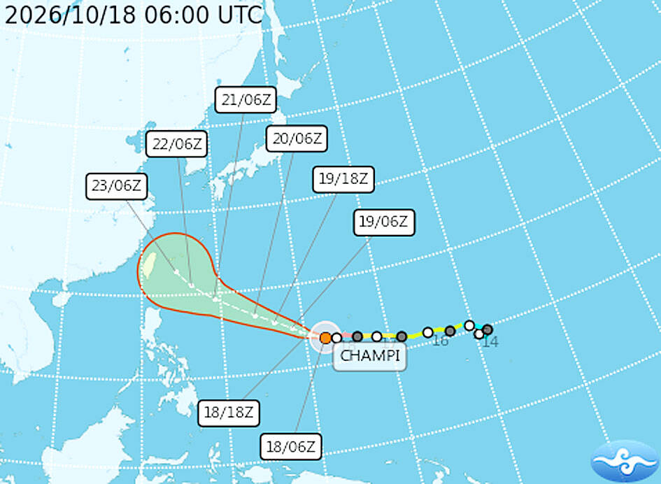
A sea warning for Typhoon Champi could be issued as early as Wednesday night, possibly followed by a land warning on Thursday night or Friday, as the storm approaches Taiwan, the Central Weather Administration said yesterday. [1] The typhoon is expected to have its greatest impact on Taiwan on Friday and Saturday, bringing heavy rain to central and northern Taiwan and to Yilan and Hualien counties in the east, CWA forecaster Liu Pei-teng said. [1] As of 2pm yesterday, Champi was about 2,470km east-southeast of Oluanpi, Taiwan’s southernmost tip, moving westnorthwest at 20kph. [1] It had maximum sustained winds of 191kph and a storm radius of 200km, CWA data showed. [1] Forecasts suggest Champi would maintain its strength as it heads toward waters northeast of Taiwan, Liu said. [1] Ahead of the typhoon, the weather would remain relatively stable today and tomorrow, with mostly cloudy to sunny skies across Taiwan, the CWA said. [1] Brief, isolated showers are possible along the Keelung coast, in northeastern and southeastern Taiwan, and on the Hengchun Peninsula, it said. [1]
Uncertainties in Champi's Path
Some forecast models suggest Champi could make landfall in eastern Taiwan, but its track remains uncertain because the strength of the Pacific high-pressure system could affect its path, Liu said. [1] If the high-pressure system weakens sooner than expected, Champi could turn north before approaching Taiwan, Liu said. [1] If the system strengthens, the typhoon could take a more southerly track or pass through the Bashi Channel, between Taiwan and the Philippines, he said. [1] International forecast models continue to show divergent tracks, and tomorrow would be key in determining whether Champi turns north, Liu added. [1] The projected path of Typhoon Champi as of 6am yesterday was provided by the Central Weather Administration. [1]

Storm clouds gather over Nicosia at the beginning of the month. — Source: cyprusmail
Hurricane Trudy Strikes Mexico
Hurricane Trudy lashes Mexico's Pacific coast, but is set to weaken tonight. [2]
Record El Niño and Global Effects
Britain and China don’t agree on too many things. Both agree, however, that the 2026-27 El Niño weather event is likely to be the most powerful ever. [3] “We should be clear that this is an unprecedented event… I have never seen an El Niño signal this intense in our forecasts,” warned the head of long-range forecasting at the UK Met Office, as quoted by the BBC. [3] A month later, the Global Times reported that “China’s National Climate Center (NCC) has forecast that the ongoing El Niño event is likely to become the strongest on record.” [3] “El Niño directly affects all regions adjacent to the region in question,” Dr Filippos Tymvios, director of the Department of Meteorology, said in an emailed response. [3] Global effect of El Niño: Because the magnitude of this event is so large, however, it also indirectly affects the weather across the whole planet. [3] The ‘region in question’ is the Pacific, where trade winds push warm surface waters from the east Pacific (off South America) to the west (off Australia). [3] If the winds are gentler than usual, the flow of warmer water decreases, so the west becomes cooler and the east becomes warmer – which, since warmer air holds more moisture, means more rain in the east. [3] This is El Niño. [3] The reverse occurs when the trade winds are stronger than usual, making the western Pacific (even) warmer and wetter. [3] This is La Niña. [3] Both phenomena last about one year and occur every two to seven years, according to Wikipedia – and, as Tymvios notes, indirectly affect global temperatures, not just the Pacific. [3] Two things make this year’s ongoing El Niño special. The first is its magnitude. From October to December, the anomaly in sea-surface temperature is forecast to reach about 3.7 degrees Celsius. [3] “This is the highest since observations began, and is stronger than the previous record of + 2.6 degrees Celsius in November 2015-January 2016,” according to the World Meteorological Organization (WMO). [3] The second important point, for us, is that this El Niño is going to be combined with a positive phase for the so-called Indian Ocean Dipole, which – to put it simply – is a similar oscillation to El Niño for the Indian Ocean. [3] “A study by the Hebrew University of Jerusalem has linked this combination to more frequent ‘Cyprus Lows’ – as they’re known in the literature – and increased rainfall in parts of the eastern Mediterranean and the Middle East,” writes Tymvios, adding (like any good weatherman) that of course it’s merely “a statistical trend”, not a cast-iron guarantee of a rainy winter. [3] The effects of a ‘super’ El Niño shouldn’t be underestimated. The one in 1997-98 caused an estimated 16 per cent of the world’s reef systems to die. [3] The other worrying development was spelled out by the WMO’s Saulo, in a recent speech to the Global Heat Forum in Bangkok. “El Niño doesn’t add new heat to the planet. It releases heat the ocean has already been storing beneath the surface,” she pointed out. [3] That’s why – even though there’s no evidence that global warming leads to more frequent El Niños – it can make them more intense when they do happen. [3] More heat available: “The ocean it’s drawing from is the warmest we’ve ever measured it. There is simply more heat available to release,” she said. [3] It’s a vicious circle. A warmer ocean leads to a stronger El Niño – which, in turn, sends average temperatures soaring and leads, down the line, to a warmer ocean. [3] “Certainly, we’re concerned about the impact of El Niño on an already warming atmosphere – and we acknowledge that the temperature of the entire planet is likely to rise to record levels,” admits Tymvios, echoing the UK Met Office which (as per the BBC article) thinks it’s “very likely” that 2027 will be the hottest year on record globally. [3]
Wetter Winter Outlook for Cyprus
Still, he adds: “Analysis of the IMS/ECMWF seasonal forecast maps for Cyprus indicates a generally wetter start to the period. For the October-December timeframe, it suggests approximately 20-70 per cent more rainfall, depending on the area, with the signal being strongest in October.” [3] This is slightly different to the rest of the world, where El Niño is expected to peak around December and persist through to February 2027, according to WMO secretary-general Celeste Saulo. [3] In Cyprus, the high-water mark of the extra rainfall is probably now, this month and possibly the next. [3] In fact, writes Tymvios, “for December-February, precipitation mostly appears around normal levels, and even a bit lower.” [3] We in Cyprus might be relatively sheltered, but this year’s super-event is sure to cause flooding, droughts, potential wildfires, and other disruptions to the global weather system – and of course that 20-70 per cent extra rainfall could end up causing problems here too. [3] In the short term, however – looking at it purely through local, not global eyes – Cyprus is tentatively calm about the big bad El Niño. [3]
Ongoing Flood Warnings in the US
The Flood Warning continues for the following rivers in Florida. [4] The St Johns River at Astor is forecast to remain in Minor Flood Stage today, but strong northeasterly winds will slow river flow leading to a quicker rise in levels tonight. [4] The river is forecast to reach Moderate Flood Stage early Monday, and remain in Moderate Flood through the end of this week. [4] For the St. Johns River...including Astor...Moderate flooding is occurring. [4] The Flood Warning continues for the following rivers in Georgia. [5] Satilla River At Atkinson affecting Brantley County. [5] Additional information is available at https://water.weather.gov/wfo/JAX. [5] The next statement will be issued Monday morning at 915 AM EDT. [5] WHAT...Minor flooding is occurring and minor flooding is forecast. [5] WHERE...Satilla River at Atkinson. [5] WHEN...Until further notice. [5] IMPACTS...At 13.0 feet, Warners Landing, Louis Landing and secondary roads around KOA campgrou. [5]
What to watch next: A sea warning for Typhoon Champi could be issued as early as Wednesday night, possibly followed by a land warning on Thursday night or Friday. [1] Hurricane Trudy is set to weaken tonight. [2] For the October-December timeframe, Cyprus rainfall analysis suggests approximately 20-70 per cent more rainfall. [3]