
Hurricane Tracker Shows Pilandok as Tropical Storm With No Philippines Impact
The hurricane tracker shows Tropical Storm Pilandok intensifying from a tropical depression while the southwest monsoon brought moderate to heavy rain to parts of the Philippines, as Spain recorded over 5,000 heat-related deaths since June and tropical storm warnings were issued for parts of the Texas Gulf Coast.
Pilandok Strengthens Into Tropical Storm
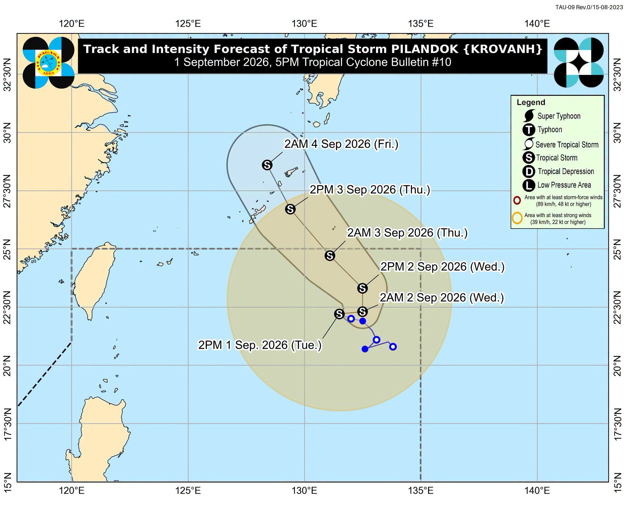
Tropical Depression Pilandok intensified into a tropical storm located 1,015 km east of extreme Northern Luzon. [1] The system moved northwest at 10 km/h with maximum sustained winds of 65 km/h and gusts up to 80 km/h. [1] It has no current effect on the Philippines. [1] With its current track, the storm may exit the Philippine Area of Responsibility by late Wednesday or early Thursday. [1] It will remain over the northern Philippine Sea as a tropical storm before approaching Okinawa, Japan. [1] The hurricane tracker continues to follow these movements closely as the system stays distant from land areas in the region.
Southwest Monsoon Triggers Heavy Rain and Gusty Winds
The southwest monsoon is causing moderate to heavy rain of 50-100 mm in Batanes, Ilocos Norte, Ilocos Sur, and Zambales. [1] Scattered rain and thunderstorms affect Metro Manila, Cordillera Administrative Region, the rest of Ilocos Region, the rest of Cagayan Valley, the rest of Central Luzon, Cavite, Batangas, Rizal, Occidental Mindoro, Aklan, and Antique. [1] Isolated rain showers or thunderstorms are expected across the rest of Luzon and Visayas. [1] From Tuesday afternoon to Wednesday afternoon, moderate to heavy rain of 50-100 mm targets Batanes, Ilocos Norte, Ilocos Sur, and Zambales. [1] From Wednesday afternoon to Thursday afternoon, the same rainfall amounts reach Ilocos Norte, Ilocos Sur, La Union, Pangasinan, Abra, Benguet, Zambales, Bataan, and Occidental Mindoro. [1] From Thursday afternoon to Friday afternoon, heavy to intense rain of 100-200 mm falls over Occidental Mindoro while moderate to heavy rain of 50-100 mm covers Zambales, Bataan, Pampanga, Cavite, Batangas, Oriental Mindoro, and Antique. [1] Strong to gale-force gusts occur over most of Luzon and Visayas plus Zamboanga del Norte, Misamis Occidental, Lanao del Norte, Misamis Oriental, Camiguin, Dinagat Islands, Davao Occidental, and Davao Oriental through Thursday. [1] Seas reach up to 5 meters high on the western seaboards of Batanes and Babuyan Islands and the seaboard of Ilocos Norte. [1] Waves up to 4.5 meters high affect the seaboards of Ilocos Sur and northern La Union, the western seaboard of Pangasinan, the northern seaboard of Babuyan Islands, and the remaining seaboard of Batanes. [1] Waves up to 4 meters high occur on the seaboard of Zambales. [1] Waves up to 3.5 meters high reach the seaboard of Lubang Islands, the western and southern seaboards of Bataan, and the western seaboards of Cavite and Batangas. [1] Waves up to 3 meters high cover the remaining seaboard of Babuyan Islands, the western seaboards of northern Occidental Mindoro, Calamian Islands, and northern Palawan, and the northern and western seaboard of Kalayaan Islands. [1] Waves up to 2.5 meters high appear on the seaboard of Isabela, the western seaboard of central Palawan, the eastern seaboard of Davao Oriental, the remaining seaboards of Kalayaan Islands, Pangasinan, and La Union, the northern seaboard of Calamian Islands, and the remaining western seaboard of Occidental Mindoro. [1] Waves up to 2 meters high extend across seaboards of mainland Cagayan, northern Aurora, Romibon, Cuyo Islands, Antique, Surigao del Sur, and Davao Occidental, the western seaboard of Burias Island, the southern seaboards of Quezon, Marinduque, Oriental Mindoro, Iloilo, and Guimaras, the southwestern seaboard of Negros Occidental, the remaining western seaboard of mainland Palawan, and the remaining seaboards of Occidental Mindoro and Davao Oriental. [1]

Spain records over 5,000 heat-related deaths since June. — Source: thelocal-spain
Record Heat-Related Deaths in Spain
Spain registered more than 5,000 heat-related deaths from June to August. [2] This total marks a record since statistics began in 2015. [2] A fifth heatwave of the summer is on the way. [5]
Tropical Storm Warnings Issued for Texas Gulf Coast
Tropical Storm Warnings are in effect for Sabine Lake and coastal waters from High Island to Freeport, Texas. [3] [4] Southeast winds reach 30-35 kt with gusts up to 50 kt near the center. [3] Seas measure 4-8 ft. [3] Winds of 20-25 knots with gusts up to 45 knots occur in rainbands over coastal waters from High Island to Freeport out 20 NM. [4] Seas there stand at 3-5 ft, occasionally higher. [4] The warnings cover this evening into tomorrow for Sabine Lake areas and until 9 AM CDT Wednesday for the coastal waters zone. [3] [4] Impacts include hazardous seas that can capsize vessels and reduce visibility. [3] [4]
Additional Systems Monitored and September Outlook
Tropical Storm Saudel, formerly Obet, was located 685 km west of Calayan, Cagayan. [1] It moved east northeastward at 30 km/h with winds of 65 km/h and gustiness up to 80 km/h. [1] A low pressure area located 3,010 km east of southeastern Luzon still holds a medium chance of developing into a tropical depression in the next 24 hours. [1] PAGASA forecasts two to three tropical cyclones may develop within or enter the Philippine Area of Responsibility in September. [1]
Haze from Indonesian Fires Affects Visibility
Haze due to forest fires from Kalimantan, Indonesia, affects the western portions of Visayas, Mimaropa, and Mindanao. [1]
What to watch next: PAGASA continues monitoring Tropical Storm Saudel and the low pressure area while expecting two to three tropical cyclones to develop within or enter the Philippine Area of Responsibility in September.