
Hurricane Tracker Shows First Atlantic Hurricane-Free September Since 1994
The hurricane tracker update reveals that the Atlantic basin recorded its first hurricane-free September in more than three decades, with no hurricanes striking Mexico's eastern coast, while the Pacific side saw 20 named storms and nine hurricanes including three Category 5 systems. [3]
Atlantic Hurricane Lull Ends as Isaias Forms
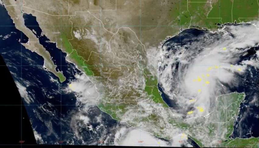
The hurricane tracker shows the Atlantic basin recorded its first hurricane-free September in more than three decades. [3] No hurricanes struck Mexico's eastern coast during that period. [3] Tropical Storm Isaias formed in the southwestern Gulf of Mexico north of Veracruz and west of the Yucatán Peninsula. [3] Forecasters expected Isaias to strengthen into the season’s first Atlantic hurricane. [3] Its maximum sustained winds stood at 45 mph at 9 a.m. Mexico City time on Wednesday. [3] The National Hurricane Center forecast Isaias to reach hurricane strength with winds of at least 75 mph early Thursday. [3] Peak intensity was projected early Friday at 110 mph near the top of the Category 2 range. [3] Increasing wind shear could weaken Isaias before landfall yet the system was still expected to reach the southern U.S. late Friday or early Saturday. [3] The storm could bring 5 to 10 centimeters of rain around the Bay of Campeche and the Yucatan Peninsula before that time. [3]
El Niño Drives Pacific Activity and Atlantic Suppression
A super El Niño is driving the contrast by shifting warm water to the northeastern Pacific, reducing wind shear there while increasing it in the Atlantic to suppress storm development. [3] Specialists at the National Autonomous University of Mexico noted that warmer water from the central equatorial Pacific shifted toward the northeastern Pacific off Mexico, supplying more energy for cyclones to form and intensify. [3] El Niño also tends to reduce vertical wind shear in the eastern and central Pacific, creating conditions more favorable for hurricanes. [3] In the Atlantic the same pattern tends to increase vertical wind shear, which can tear apart developing storms. [3] Mexico’s National Meteorological Service had projected 18 to 21 tropical cyclones in the eastern Pacific and 11 to 15 in the Atlantic months earlier. [3] September illustrated the contrast sharply as the statistical peak of the Atlantic hurricane season passed without a single hurricane. [3]
Pacific Basin Produces Multiple Major Hurricanes
Through Wednesday the Pacific basin stretching from the Americas westward to the International Date Line had produced 20 named storms and nine hurricanes during the 2026 season that began May 15. [3] Three of those hurricanes reached Category 5 intensity. [3] Hurricane Genevieve formed well off Mexico’s Pacific coast in July. [3] Hurricane Lowell formed in the Eastern Pacific in August and moved toward Hawaii. [3] Hurricane Polo pounded the Baja Peninsula and the Sonora coast in September. [3] On the country’s Pacific side the storms kept churning while the Atlantic remained quiet. [3]
Severe Thunderstorms Strike Western New York
The National Weather Service in Buffalo issued a Severe Thunderstorm Warning for northeastern Niagara County, Orleans County, and northwestern Monroe County in western New York until 1030 PM EDT. [1] At 936 PM EDT a severe thunderstorm was located over Newfane or 10 miles north of Lockport moving east at 45 mph. [1] Hazards included 60 mph wind gusts and quarter size hail according to radar indications. [1] Impacts were expected to include hail damage to vehicles. [1]
Flash Flood and River Flood Warnings Issued in Florida
The National Weather Service in Tampa Bay Ruskin issued a Flash Flood Warning for northwestern Hillsborough County and southeastern Pinellas County until 1045 PM EDT. [5] At 914 PM EDT local law enforcement reported thunderstorms producing heavy rain across the warned area. [5] Between 1 and 3 inches of rain had fallen with an additional 1 to 2 inches possible. [5] Flash flooding was already occurring. [5] The Flood Warning continued for the Withlacoochee River at US 41 Dunnellon affecting Levy, Citrus, and Marion Counties. [2] Elevated water levels continued on the Withlacoochee River at Dunnellon due to a combination of excessive hydrilla growth along a 4.5 mile stretch of river between U.S. 41 and Lake Rousseau and recent heavy rainfall. [2] Water levels were expected to hold steady for the next several days remaining above flood stage. [2] Minor flooding was occurring along the river. [2]
Season Outlook Through November
Both hurricane seasons run through Nov. 30. [3] The 2026 Atlantic lull might be over with Tropical Storm Isaias now in the Gulf of Mexico. [3] The National Hurricane Center expected Isaias to reach the southern U.S. late Friday or early Saturday while possibly bringing 5 to 10 centimeters of rain to parts of Mexico beforehand. [3] The contrast between basins was forecast months ago and continued to shape activity into early October. [3]
What to watch next: Tropical Storm Isaias is forecast to become the first Atlantic hurricane of the season and reach the southern U.S. late Friday or early Saturday while both seasons continue through Nov. 30.