/wz.lviv.ua/images/news/_cover/559377/img4437.webp)

Etna Ash Forces Flight Limits at Catania Airport Amid Natural Disasters
Mount Etna in Sicily has emitted large volumes of volcanic ash from its northeast crater, sending plumes up to four kilometers high, prompting flight restrictions at Catania airport while authorities in other regions report unrelated geological phenomena at dormant sites and ongoing volcanic activity elsewhere amid natural disasters. Etna's ash clouds pose risks to aviation by reducing visibility and potentially damaging aircraft engines, leading to canceled or diverted flights to Palermo and Comiso with restrictions possibly continuing. [1] Volcanologists describe Etna's current activity as typical for the volcano and do not anticipate a major eruption; the 3400-meter stratovolcano is one of Europe's highest active volcanoes and a UNESCO World Heritage site. [1]
Etna Ash Plume Disrupts Sicilian Air Travel
Etna throws out significant volumes of ash from the northeast crater. [1] Clouds rise to a height of up to four kilometers and pose a danger to aviation. [1] Volcanic ash can not only worsen visibility but also enter aviation engines, which can cause their damage. [1] Some flights are canceled or redirected to other airports in Sicily, in particular to Palermo and Comiso. [1] Passengers are advised to check the status of their flights before traveling to the airport. [1] It is still unknown when Catania will be able to fully resume operations. [1] Restrictions may continue on Tuesday. [1] At the same time, volcanologists do not expect a large-scale eruption. [1] They characterize the current activity of Etna as typical for this volcano. [1]
Profile of Mount Etna and Its Typical Activity
Etna is a stratovolcano on the eastern coast of Sicily about 3400 meters high. [1] Its height can change due to constant volcanic activity. [1] The volcano is considered one of the highest active volcanoes in Europe and the highest mountain in Italy south of the Alps. [1] Etna is almost constantly in a state of weak activity, and stronger eruptions periodically cause disruptions in the operation of Catania airport. [1] Etna is included in the UNESCO World Heritage list. [1] Volcanic activity in this area began approximately half a million years ago. [1] In ancient Greek and ancient Roman mythology, it was believed that the forge of the gods Vulcan or Hephaestus was located under Etna. [1] At the same time, modern research continues to change scientists' ideas about the nature of the volcano. [1] In particular, researchers from the University of Lausanne suggest that the mechanism of Etna's operation may differ from classical models of volcano formation. [1]
Investigation into Vapors at Syria's Jabal Kawkab
Mysterious vapors emerging from the ground near an ancient volcanic formation in northeast Syria have prompted scientists to investigate whether recent seismic activity disturbed the geology beneath the area. [2] Videos from Jabal Kawkab, around 15 kilometres east of Hasakah, showed white vapour rising from cracks in the ground, alongside reports of subsidence in the surrounding area. [2] The phenomenon sparked speculation on Syrian social media that the ancient volcano could be reawakening, particularly after an earthquake was felt across parts of northern Syria last week. [2] But geologists have cautioned that there is currently no evidence of renewed volcanic activity, with several other possible explanations being investigated. [2] Syrian authorities have now sent specialist teams to Jabal Kawkab to examine the cracks, measure the emissions and determine what is happening beneath the surface. [2] Jabal Kawkab is an ancient volcanic formation rising from the plains east of Hasakah. [2] Its volcanic origins made the appearance of vapour particularly striking, but scientists say images of emissions from the ground are not sufficient to demonstrate that magma or renewed volcanic activity is involved. [2] One preliminary explanation being examined by Syrian geologists is that groundwater could be travelling through newly opened fractures and reaching warmer layers underground, producing vapour at the surface. [2] Scientists are also investigating whether recent seismic activity contributed to the appearance of the cracks or altered existing underground pathways. [2] Dr Abdul-Moneim Issa Hassan, a geology lecturer at Homs University who is originally from Hasakah, has urged caution over claims that the phenomenon is volcanic. [2] Hassan said the nature and source of the emissions could not be determined from videos alone and called for gas analysis, measurements of soil and rock temperatures and geophysical surveys of the area. [2] He also pointed to possible non-volcanic explanations linked to the history of the site. [2] The area around Jabal Kawkab includes an old rubbish dump and has previously been used for military purposes, meaning buried waste or other material could also potentially be responsible for the emissions. [2] Determining the composition and temperature of the gases will therefore be crucial in establishing whether their origin is geological, environmental or linked to human activity. [2] The General Establishment of Geology and Mineral Resources has dispatched specialists to examine the site and investigate underground cavities and fractures. [2] Local environmental authorities are also preparing to analyse the emissions. [2] However, the legacy of Syria's war has complicated even a geological investigation. [2] Before environmental specialists can safely work across the affected area, mine-clearance teams are checking it for unexploded ordnance and other remnants of war. [2] Hasakah's Environment Directorate has said the area has been cordoned off while the investigation continues, with residents and journalists urged not to approach the affected sites. [2] The different teams are expected to examine the composition of the gases and the geology beneath the mountain before determining the most likely cause. [2] For now, there is no indication from Syrian geological authorities that Jabal Kawkab is undergoing a volcanic eruption or that one is imminent. [2] The appearance of vapour shortly after seismic activity has nevertheless drawn attention to a geological feature that has remained dormant for thousands of years. [2] Establishing whether the earthquake played any role will require scientists to determine whether new fractures were created, existing faults shifted or the timing of the two events was simply coincidental. [2] Until laboratory analysis and geophysical surveys are completed, scientists say the origin of the mysterious vapours remains unresolved. [2]
Volcanic ash rises from Mount Etna's northeast crater. — Source: gdelt
Access Ban at Indonesia's Ile Lewotolok Volcano
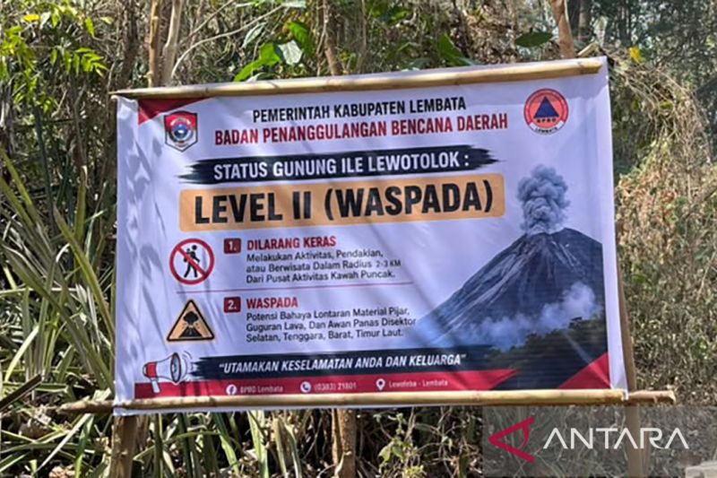
The Center for Volcanology and Geological Disaster Mitigation prohibits tourists or climbers from carrying out activities within a 2 km radius from the center of activity of Mount Ile Lewotolok in Lembata, East Nusa Tenggara Province. [3] Observer of Mount Ile Lewotolok Stanislaus Ara Kian said that in every recommendation report sent, his party always conveys the prohibition. [3] “According to the recommendation, it is not allowed to carry out activities within a 2 km radius from the center of activity of Mount Ile Lewotolok,” he said. [3] He said that even though it has been prohibited, there are still tourists or climbers who are naughty who carry out activities in the radius prohibited by the PVBMG. [3] According to him, currently the status of the mountain is still on alert status. [3] In addition, surface activity is also quite high so it is dangerous if there are tourists and climbers who carry out activities in that radius. [3] He said the Lembata Regency Government has also issued the appeal, but it is still being violated, meaning that if something happens in the area, it will be their own responsibility. [3] “If something happens outside our responsibility, but it will make many people difficult later,” he said. [3] Previously, the Lembata Regency Government of East Nusa Tenggara Province limited the activities of tourists and the community in the Mount Ile Lewotolok area following an increase in volcanic activity of the mountain. [3] “Customary and cultural activities, which involve mass crowds in disaster-prone areas, tourism, including the Kacang Festival, are temporarily postponed until further notice from the local government based on recommendations from PPGA-PVMBG,” said Lembata Regent Kanisius Tuaq in a circular issued in Lewoleba. [3] He explained that the restriction was implemented as a mitigation step to protect the community from potential hazards of eruption, hot clouds, ejected material, toxic gas and rain lahars in the volcanic area. [3]
Heimaey Residents' Defense Against 1973 Eldfell Eruption in Context of Natural Disasters
The Eldfell volcano erupted in January 1973. [4] The earth opened up in the middle of the night and started spewing fire and lava everywhere. [4] Miraculously, only one person died in the aftermath; all the islanders' boats were in the harbour that night, sheltering from a storm, so when they had to evacuate, there was enough space for everyone on board. [4] Most of the 5300 residents fled to the mainland; those who stayed behind fire-hosed the advancing lava with icy seawater in the hope it would cool and solidify. [4] The eruption continued for nearly six months, and powerful water pumps were brought in to redouble the fire-hoses' efforts. [4] Though 400 houses were buried in lava and ash, the molten flow was halted before it could destroy Heimaey's fishing industry. [4] The air is pungent with the odour of this primary export - cod, haddock, tusk, ling - as we sail past a fish-processing factory in Vestmannaeyjar, the island's harbour settlement. [4] This we call 'the money smell', because fishing is the main source of money here on the island. [4] A volcano-affected house at Eldheimar museum. [4] The sea air swallows the polarising scent as we cast out along Heimaey's eastern flank. [4] Beside us, Eldfell's cone is a lanced boil on the blistered landscape; now a popular hiking spot, it overlooks a partially buried house, preserved as a reminder beside the volcano museum of remembrance, Eldheimar. [4] Seabirds and livestock were also displaced during the eruption; like most of their human cohabitants, they've returned. [4] Bluffs and islets are streaked with the orange of puffins' beaks; Icelandic sheep drift like balls of cottonwool on precipitous clifftops. [4] My whole life I've lived here, and I've only heard of two sheep that have fallen into the ocean. [4] To the west looms Iceland's newest island, Surtsey, which arose almost fully formed after erupting underwater in 1963. [4] When people saw smoke rising out of the ocean they thought the world was ending. [4] But it sounds like a whole new world was just beginning. [4]
What to watch next: Etna ash restrictions may continue while volcanologists assess typical activity, Syrian teams analyze Jabal Kawkab emissions for non-volcanic causes, Indonesia maintains the 2 km ban at Ile Lewotolok due to high surface activity, and Heimaey continues to feature the Eldheimar museum from the 1973 eruption.