
58 Wildfires Burn in Algeria as Heatwave Continues Amid Natural Disasters
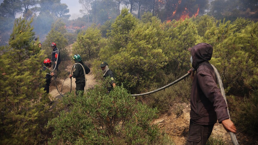
Wildfires are burning in multiple countries amid heatwaves, drought and climate-driven conditions as part of ongoing natural disasters, with Algeria reporting 58 active fires, Indonesia combating forest and land fires through technology and patrols to protect orangutan habitats, and Greece and Cyprus tackling new blazes that have already consumed thousands of hectares this summer. [1] Algeria contends with 58 wildfires amid an ongoing heatwave. [1] Twenty-one fires have since been extinguished while efforts remain underway to put out the rest. [1]
Algeria Battles Dozens of Fires in Prolonged Heatwave
Algeria contends with 58 wildfires amid an ongoing heatwave. [1] Twenty-one fires have since been extinguished while efforts remain underway to put out the rest. [1] The situation in Algeria illustrates the immediate pressures on emergency responders during periods of extreme heat. [1] Officials continue directing resources toward the remaining fires that have not yet been contained. [1] The heatwave conditions have persisted, complicating containment operations across affected regions. [1] Algeria's response focuses on extinguishing active blazes while monitoring for any new ignitions. [1]
Indonesia Deploys Satellite Technology for Fire Detection and Mapping
Indonesia's National Research and Innovation Agency is urging wider use of satellite and geoinformatics technology to detect and tackle forest and land fires. [2] Geoinformatics technology plays a crucial role in managing forest and land fires through three main functions. [2] Its first role is to serve as an early warning system based on weather prediction models that develop daily fire-weather and drought-risk indexes. [2] The climate monitoring model has been developed and is now fully operated by Indonesia's Meteorology, Climatology, and Geophysics Agency. [2] The second role is to monitor fire indicators through hotspot tracking that can detect daily hotspots across Indonesia. [2] To promote data transparency and public access, a free web-based digital monitoring platform has been provided. [2] The third role of geoinformatics is to estimate and map burned forest areas using high-resolution satellite imagery from Landsat and Sentinel-1 and Sentinel-2. [2] The resulting estimates of fire-affected areas are submitted monthly to the Forestry Ministry. [2] Daily satellite hotspot data are crucial as an early warning tool. [2] All hotspot data must be followed by accurate field verification because materials such as metal roofs can also trigger satellite detections. [2] Thermal drones and remote surveillance cameras help determine whether detected hotspots represent actual fires. [2]

Indonesian officials discuss using satellites to monitor and combat forest and land fires. — Source: antaranews
Protecting Orangutan Habitats Amid Indonesian Wildfires
Indonesia's Forestry Minister Raja Juli Antoni has urged continued patrols to ensure forest and land fires in East Kalimantan's Berau District do not threaten Bornean orangutan habitats. [4] The minister stated that the visit to Berau aimed to ensure wildfires do not harm communities or wildlife, especially orangutans. [4] The government continues efforts to prevent, control, and extinguish forest and land fires while safeguarding wildlife habitats. [4] Regular patrols are required to protect orangutan habitats from wildfire threats. [4] Indonesia is particularly concerned about this year's weather because El Niño arrived earlier and with unusual strength according to the Meteorology, Climatology, and Geophysics Agency. [4] The minister noted that this year's fires are linked to extraordinary climate change and that El Niño usually occurs every four years but climate change is real. [4] Wildlife protection forms an important part of the government's response alongside protecting communities. [4] A conservation area in the Keraitan orangutan landscape has been designated to protect orangutan habitat in cooperation with the Long Sam Wildlife Rehabilitation Center and other partners. [4] The Keraitan landscape covers 87 hectares and serves as an important orangutan habitat. [4]
Rapid Containment of Blaze in Cyprus
A wildfire which broke out in the Ayia Anna area of Larnaca on Wednesday afternoon was brought fully under control after burning around six hectares of vegetation. [3] The fire broke out at around 3pm in the bed of the Tremithos river within the administrative boundaries of Agia Anna and was brought fully under control at 5.30pm. [3] The blaze burned around six hectares of reeds, wild grasses and dry vegetation. [3] Strong ground and aerial forces were deployed including five firefighting aircraft. [3] The fire service supported the operation with three fire engines. [3] Forestry department forces included six fire engines, two water tankers and a bulldozer with a total of 33 personnel involved. [3] A forestry department aerial operations coordination officer was deployed to coordinate the firefighting aircraft. [3] The fire was spotted by one of its fire lookout posts at 2.58pm. [3]

Firefighting aircraft deploys over a wildfire in Cyprus. — Source: cyprusmail
Greece Faces New Fires and Warnings of Difficult Days Ahead
A new forest fire broke out in northern Greece near the village of Paraskevi in the Deskati area of Grevena. [5] Five water-bombing planes and helicopters assisted 50 firefighters battling the blaze. [5] Another blaze broke out in farmland and forest near the village of Aghios Antonios in the northern Kilkis area, mobilizing three aircraft and 38 firefighters. [5] Authorities formally confirmed that a blaze on the island of Salamina had been extinguished after forcing the evacuation of two settlements. [5] So far this summer some 30,000 hectares of land have been lost to wildfires, among them 2,800 hectares of forest. [5] In 89 percent of the cases where the cause has been determined, the blazes were due to negligence and 11 percent resulted from arson. [5] Seven people have been killed by wildfires in recent weeks. [5] The Climate Crisis and Civil Protection Minister warned that the end of the summer is expected to be tough for firefighters with strong winds forecast amid high temperatures. [5] The next few days will be difficult because right now everything is like dynamite and everything has dried up following protracted high temperatures. [5] For Thursday the Greater Athens area and Attica, southern Evia, Crete, the Cyclades, Chios, Samos, Ikaria and many of the Dodecanese islands will face a category-4 wildfire threat. [5]
Broader Context of Global Wildfire Response to Natural Disasters
Different nations are addressing natural disasters through technology, habitat protection and emergency deployment under heat and drought stress. [1] [2] [3] [4] [5] Algeria continues directing resources toward remaining fires after extinguishing 21 of the 58 reported blazes during the heatwave. [1] Indonesia promotes satellite tools for early warning via fire-weather indexes, hotspot monitoring and burned-area mapping with Landsat and Sentinel imagery while requiring field verification to avoid false positives from metal roofs. [2] Ministerial directives in Indonesia emphasize patrols in Berau District to protect orangutan habitats amid an early and strong El Niño linked to climate change, including designation of an 87-hectare conservation area in the Keraitan landscape. [4] Cyprus achieved rapid containment of a six-hectare fire in reeds, wild grasses and dry vegetation using ground and aerial resources after detection by a lookout post. [3] Greece battles new fires near Grevena and Kilkis with water-bombing aircraft and ground crews while warning of high risk across Greater Athens, islands and Crete due to strong winds and tinder-dry conditions, noting that 30,000 hectares have burned this summer with 89 percent of determined causes linked to negligence and seven fatalities recorded. [5] Coordinated use of monitoring platforms, patrols and rapid response teams reflects ongoing efforts to manage wildfire impacts across regions facing similar climate pressures. [2] [4] [5]
What to watch next: Authorities in Greece have warned that the next few days will be difficult with strong winds forecast amid high temperatures while Indonesia continues patrols and satellite monitoring to protect habitats from fires linked to the early El Niño.