2,500-Meter Ash Column Rises From Indonesia's Lewotobi Laki-laki Volcano Eruption Today
Gunung Lewotobi Laki-laki produced a volcano eruption today that sent a gray ash column 2,500 meters above the summit, drifting southwest and west while lasting about two minutes and five seconds. [1] The event was recorded on the seismogram with a maximum amplitude of 47.3 millimeters and included booming sounds. [1] Material from the column reached approximately 4,084 meters above sea level. [1] This volcano eruption today occurred at 08:30 WITA on August 27 in East Flores, Indonesia, and placed the volcano in ongoing focus alongside lahar concerns elsewhere. [1]
Indonesia Eruption Details
The volcano eruption today at Gunung Lewotobi Laki-laki began at 08:30 WITA on August 27 with an ash column that reached 2,500 meters above the summit. [1] Observers described the column as gray with thick intensity, moving toward the southwest and west. [1] The eruption lasted about two minutes and five seconds according to the seismogram reading that showed a maximum amplitude of 47.3 millimeters. [1] Booming sounds accompanied the activity. [1] With the column height measured, material reached about 4,084 meters above sea level. [1] The monitoring report from the observer at the site confirmed these details through direct observation and instrument data. [1] The short duration and specific amplitude reading allowed authorities to classify the event quickly while noting its visible effects on the surrounding area. [1] Residents nearby could see the column clearly as it drifted, and the seismic trace provided precise timing for the two-minute-five-second span. [1] The combination of visual and instrumental evidence established the scale of this volcano eruption today without requiring further immediate escalation in reported activity. [1]
Current Alert Status and Safety Measures

A gray ash column rises 2500 meters from Indonesia's erupting Lewotobi Laki-laki volcano. — Source: gdelt Gunung Lewotobi Laki-laki remains at Level III (Siaga) alert status following the volcano eruption today. [1] A five-kilometer exclusion zone around the eruption center stays in effect for residents, visitors, and tourists. [1] Authorities continue to warn of potential rain-triggered lahars in rivers that originate on the summit, with specific communities listed as Dulipali, Padang Pasir, Nobo, Nurabelen, Klatanlo, Hokeng Jaya, Boru, and Nawakote. [1] People affected by ashfall are advised to wear masks or cover their nose and mouth to reduce respiratory risks from volcanic ash exposure. [1] Local government is instructed to maintain coordination with the observation post in Desa Pululera, Kecamatan Wulanggitang, Kabupaten Flores Timur, and with the geological agency in Bandung. [1] Residents are urged to stay calm, follow directions from local authorities, and avoid unverified information. [1] The monitoring post can be reached at 022-7272606 for updates on activity. [1] Coordination between provincial disaster management and local response teams ensures that any changes after the volcano eruption today are communicated promptly. [1] The exclusion radius and lahar watch areas remain the primary safety measures while the alert level holds at Level III. [1]
Volcano Eruption Today Underscores Lahar Threat at Mount Rainier
Mount Rainier ranks among the highest-threat volcanoes according to USGS assessments because of its ability to generate lahars that could reach towns including Orting, Sumner, Puyallup, and Ashford within 15 to 60 minutes even without an eruption. [2] More than 60,000 residents live inside the lahar danger zone where flows of water, rock, mud, and debris can move like wet concrete. [2] The heavily glaciated slopes can produce such events from landslides, heavy rainfall, melting ice, or small earthquakes. [2] A lahar detection and warning system installed in 1998 uses buried sensors and tripwires along river valleys to detect vibrations and automatically alert emergency centers. [2] Upgrades between 2015 and 2021 added 14 new stations for real-time data, expanded coverage, and improved technology including seismometers and cameras. [2] Computer models indicate mudflows could reach homes and visitor areas inside Mount Rainier National Park in about five minutes and towns outside the park in 15 to 60 minutes. [2] The west flank remains vulnerable to future large-scale collapse that could send flows down multiple river paths. [2] Historical precedent includes the Electron Mudflow of 1500 AD caused by a landslide on the west flank. [2] The 1980 Mount St. Helens eruption produced a lahar that traveled more than 60 miles, destroyed over 200 homes, 195 miles of roads, and 27 bridges. [2] More than 45,000 students and staff from over 20 schools took part in a large-scale evacuation drill on April 23 to practice moving to higher ground. [2]
Nepal Disaster as Cautionary Parallel
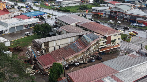
A glacier collapse and avalanche in Nepal on Wednesday triggered a lahar-like flood that killed at least 95 people and left hundreds missing. [2] The event began when an ice chunk roughly 2,000 feet wide fell thousands of feet into the Lhende Khola river valley along the Nepal-Tibet border. [2] The ice mixed with water, rock, and debris to create a sudden surge of muddy floodwater that rushed into the Bhote Koshi River and devastated the Rasuwa district. [2] At least 54 Americans are among the hundreds reported missing, with a total of 579 people unaccounted for according to Nepali police figures. [2] Surveillance cameras captured waves taller than local buildings sweeping through streets. [2] This disaster serves as a direct analog for the sudden mudflow risk that exists at Mount Rainier, where similar glacier or flank instability could produce comparable results without any volcanic eruption. [2] Scientists note that the Nepal event illustrates the speed and power of such flows once initiated. [2]
Evacuation Preparedness and Warning Signs
USGS advises residents to recognize natural warning signs of an approaching lahar, described as ground rumbling accompanied by a roaring sound like a jet or locomotive. [2] The most critical action is to move to higher ground immediately when a siren sounds or signs appear, which may require abandoning vehicles if roads become blocked. [2] The lahar warning system on Mount Rainier is designed to provide the earliest possible alert through its network of sensors. [2] Emergency officials emphasize that flows can arrive too quickly for last-minute decisions, making prior drills and awareness essential. [2] Studies continue to assess the west flank for signs of instability that could lead to large-scale collapse. [2]
What to watch next includes continued monitoring of Gunung Lewotobi Laki-laki activity through the observation post and any updates on lahar detection readings at Mount Rainier.