
Typhoon Dolphin Nears Taiwan With 144 kph Winds and Heavy Rain Forecast
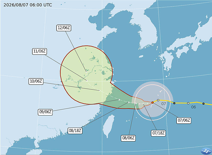
Typhoon Dolphin is approaching waters north of Taiwan with sustained winds of 144 kph and is forecast to make landfall in China's Zhejiang Province while triggering heavy to extremely heavy rainfall in northern Taiwan and the central mountains this weekend. The Central Weather Administration issued a sea warning for Typhoon Dolphin at 2:30pm yesterday as the storm steadily moved toward the waters north of Taiwan. [1] As of 5pm yesterday Dolphin was about 680km east-northeast of Taipei and moving west at 10kph with maximum sustained winds of 144kph and a storm radius of 280km. [1] While the typhoon has slowed slightly it remains within forecast expectations and would not be longer than previously predicted according to CWA forecaster Chu Mei-lin. [1]
Typhoon Dolphin Approaches Taiwan
The storm is projected to be closest to Taiwan today and tomorrow before likely making landfall in China’s Zhejiang Province between tomorrow night and Monday. [1] Dolphin is expected to maintain its strength as a moderate typhoon according to Chu Mei-lin. [1] The projected path of Typhoon Dolphin is pictured as of 2pm yesterday with data from the Central Weather Administration. [1] As it passes north of Taiwan the storm would bring significant winds and high waves according to the forecaster. [1] CWA data showed the typhoon located 680 km east-northeast of Taipei at 5pm yesterday while moving west at 10 kph with a 280 km storm radius. [1] The agency noted that the storm would maintain moderate typhoon strength through the period leading to landfall in Zhejiang Province. [1]
Forecast Rainfall and Mountain Alerts
{IMAGE_2}
Heavy or extremely heavy rain is expected over the weekend in the central mountains and the north according to the Central Weather Administration. [1] Heavy to extremely heavy rain is forecast for the northern areas and central mountains while mountainous regions north of Taichung should be on high alert for torrential rainfall according to CWA forecaster Chu Mei-lin. [1] The Central Weather Administration issued the sea warning at 2:30pm yesterday in connection with these rainfall expectations across northern Taiwan and the central mountains. [1] CWA senior weather specialist Wu Wan-hua provided additional details on the rain impacts tied to the typhoon's passage north of Taiwan. [1] The agency emphasized that the rainfall would occur as the storm passes closest to Taiwan today and tomorrow before its projected landfall in Zhejiang Province between tomorrow night and Monday. [1] Mountainous regions north of Taichung face particular concern for torrential rainfall during this period according to the Central Weather Administration. [1]
Hazardous Coastal Conditions
Long swells were expected through Monday along the north coast of Keelung eastern Taiwan Green Island Orchid Island and the Hengchun Peninsula according to CWA senior weather specialist Wu Wan-hua. [1] Central and northern coastal areas and Penghu County are also expected to experience long swells over the weekend Wu said. [1] The agency urged people to exercise caution near the coast and avoid water activities because of hazardous sea conditions. [1] As the typhoon passes north of Taiwan it would bring significant winds and high waves according to forecaster Chu Mei-lin. [1] These conditions are forecast to persist through Monday along the listed coastal areas including Keelung eastern Taiwan Green Island Orchid Island and the Hengchun Peninsula. [1] The Central Weather Administration highlighted the need for caution due to the long swells expected in multiple regions through the weekend and into Monday. [1]
Post-Typhoon Weather Outlook
Independent meteorologist Wu Der-rong said that as the typhoon moves farther away from Taiwan next week southwesterly winds are expected to bring localized showers or thunderstorms and possible heavy rain to southwestern Taiwan. [1] Other areas are forecast to remain hot and mostly sunny although afternoon thunderstorms are possible in parts of northern and central Taiwan he added. [1] The southwesterly winds are expected to weaken from Thursday but abundant moisture would continue to bring localized morning rain to southwestern Taiwan and possible afternoon thunderstorms to the western parts of the country according to Wu Der-rong. [1] These effects follow the typhoon's passage closest to Taiwan today and tomorrow and its landfall in Zhejiang Province between tomorrow night and Monday. [1] The independent meteorologist noted that the moisture effects would linger after the main storm system departs the region. [1]
U.S. Severe Weather Alerts
The National Weather Service in the Twin Cities issued a severe thunderstorm warning for northwestern McLeod County in central Minnesota and central Meeker County in central Minnesota until 1130 AM CDT with hazard of half dollar size hail. [2] A separate severe thunderstorm warning from the National Weather Service covered Martin County Minnesota with hazard of ping pong ball size hail at 1032 AM CDT for locations including Ormsby Foxlake Welcome Fairmont Northrop Fairmont Airport Truman Granada and Imogene. [5] The National Weather Service in Pittsburgh issued a flash flood warning for northeastern Armstrong County in west central Pennsylvania southeastern Clarion County in west central Pennsylvania and west central Jefferson County in west central Pennsylvania until 245 PM EDT after Doppler radar indicated thunderstorms producing heavy rain with between 0.5 and 2 inches of rain fallen and up to 1 inch more possible. [3] An additional severe thunderstorm warning was issued for Elk County Kansas at 1040 AM CDT with hazard of quarter size hail for locations including Piedmont. [4] These warnings addressed separate severe thunderstorm activity in Minnesota counties and Kansas alongside the flash flood conditions in Pennsylvania counties. [2][3][4][5]
What to watch next: Long swells continue through Monday along Keelung eastern Taiwan Green Island Orchid Island the Hengchun Peninsula central and northern coastal areas and Penghu County while southwesterly winds bring localized showers or thunderstorms and possible heavy rain to southwestern Taiwan next week with abundant moisture continuing localized morning rain and possible afternoon thunderstorms. [1]