Indonesia Volcano Eruptions Send Ash Columns Up to 1,000 Meters High
Indonesia volcano activity intensified recently as three volcanoes in eastern Indonesia — Mount Dukono and Mount Ibu in North Maluku, and Mount Lewotobi Laki-laki in East Nusa Tenggara — erupted on Friday morning, ejecting ash columns between 400 and 500 meters high, while Mount Semeru in East Java recorded six eruptions with the highest plume reaching 1,000 meters. [1][2]
Multiple Eruptions Across Eastern Indonesia
Three active volcanoes in eastern Indonesia, namely Mount Dukono and Mount Ibu in North Maluku, and Mount Lewotobi Laki-laki in East Nusa Tenggara, erupted on Friday morning according to the Geological Agency of the Energy and Mineral Resources Ministry. [1] The eruptions occurred within a short period and sent columns of volcanic ash ranging from 400 to 500 meters above the summit of their respective craters. [1] The first eruption took place at Mount Dukono in North Halmahera at 6:15 a.m. local time. [1] This was followed by Mount Lewotobi Laki-laki in East Flores at 7:04 a.m. local time. [1] Mount Ibu in West Halmahera erupted at 7:45 a.m. local time. [1] Mount Semeru in East Java separately produced six eruptions from 00:41 to 11:13 WIB on Thursday with the highest plume reaching 1,000 meters above the summit. [2]
Eruption Details and Seismic Readings
At Mount Dukono a thick white to gray ash column rose 500 meters above the crater and drifted northwest. [1] The eruption registered on a seismogram with a maximum amplitude of 12 millimeters. [1] Mount Lewotobi Laki-laki emitted a 400-meter-high gray ash column toward the west and northwest. [1] Instrumental recordings at that site showed a maximum amplitude of 47.3 millimeters lasting 46 seconds. [1] At Mount Ibu a dense gray ash column reached 400 meters and moved westward from the crater. [1] The seismic record there showed a peak amplitude of 28 millimeters with a duration of about 45 seconds. [1] On Mount Semeru the highest eruption occurred at 08:03 WIB with a column reaching 1,000 meters above the summit or 4,676 meters above sea level. [2] That column appeared white to gray with thick intensity and moved southwest. [2] It was recorded on a seismograph with a maximum amplitude of 22 millimeters and a duration of 94 seconds. [2] An earlier eruption at 00:41 WIB produced a 600-meter column that was white to gray with moderate intensity drifting southwest. [2][3]
/data/photo/2026/06/11/6a2a665a69849.jpg)
Mount Semeru emits a 1,000-meter ash plume during one of its six eruptions since dawn. — Source: gdelt
Current Alert Levels
The Geological Agency has set the activity level for Mount Lewotobi Laki-laki at Level III (Alert). [1] Mount Ibu and Mount Dukono are both at Level II (Warning). [1] Mount Semeru remains at Level III (Siaga). [2] These designations reflect the ongoing eruptive behavior observed at each site and guide the specific safety measures issued to nearby communities. [1][2]
Safety Recommendations and Restricted Zones
Because Mount Lewotobi Laki-laki remains at Alert status residents and tourists must avoid all activities within a five-kilometer radius of the eruption crater. [1] Communities at the base of Mount Lewotobi Laki-laki especially in Dulipali Klatanlo and Hokeng Jaya must stay alert for possible rain-triggered lava floods along rivers originating from the summit during heavy rainfall. [1] For the Mount Ibu and Mount Dukono areas residents and visitors are advised to remain within a designated safe radius of two to four kilometers and always wear masks and eye protection to reduce exposure to volcanic ash. [1] At Mount Semeru the public must not conduct any activities in the southeast sector along Besuk Kobokan up to 13 kilometers from the summit. [2] People are also advised not to approach within 500 meters of riverbanks along Besuk Kobokan because of the risk of expanding hot clouds and lahar flows that could reach 17 kilometers from the peak. [2] A five-kilometer exclusion zone from the crater is enforced because of the danger from incandescent rock ejections. [2]
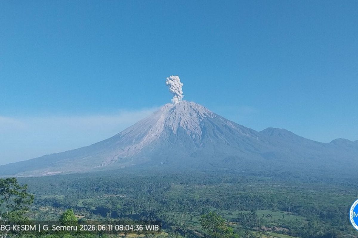
Mount Semeru emits ash plume reaching 1,000 meters during its sixth eruption. — Source: gdelt
Ongoing Seismic Activity at Semeru
During the six-hour period from 06:00 WIB to 12:00 WIB Mount Semeru recorded 18 eruption earthquakes one lava avalanche quake and six emission quakes. [2] One harmonic tremor and three distant tectonic quakes were also detected. [2] The lava avalanche quake showed an amplitude of 3 millimeters while the emission quakes ranged from 5 to 7 millimeters in amplitude. [2] The harmonic tremor reached 4 millimeters and the distant tectonic events ranged from 7 to 34 millimeters with S-P intervals of 13 to 67 seconds and durations of 36 to 115 seconds. [2] Authorities continue to warn residents to watch for hot clouds lava avalanches and lahar along rivers and valleys originating from the summit especially Besuk Kobokan Besuk Bang Besuk Kembar and Besuk Sat as well as smaller tributaries of Besuk Kobokan. [2][3]
Monitoring Updates from Geological Agency
The Geological Agency continues to track seismic and visual data from all four volcanoes to assess any changes in activity levels. [1][2] Reports from observation posts at each site provide the amplitude durations and ash column directions that inform the current alert statuses. [1][2] These measurements help determine whether additional restrictions or evacuations may become necessary in the coming days.
What to watch next: Continued seismic recordings at Mount Semeru and visual observations of ash columns at Mount Dukono Mount Ibu and Mount Lewotobi Laki-laki will determine whether alert levels are adjusted or if additional safety advisories are issued for communities near the rivers and exclusion zones.