Severe Weather Surge: The Unprecedented Convergence of Winter Storms and Wildfires in the U.S.
Overview of Current Weather Events
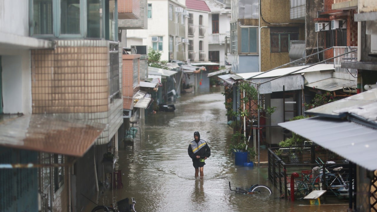
Across the U.S., an extraordinary clash of winter storms and fire weather alerts is unfolding simultaneously, straining emergency resources and exposing vulnerabilities in climate resilience—from Alaska's heavy snow to California's floods and Colorado's fire risks—as of January 26, 2026. The National Weather Service (NWS) has issued a cascade of alerts highlighting this bizarre convergence. Confirmed winter storm warnings blanket remote areas like the City and Borough of Yakutat, Alaska; the Sierra Madre Range in California; and Yellowstone National Park, forecasting 12-24 inches of snow, winds up to 60 mph, and whiteout conditions through Monday. Concurrently, fire weather watches and red flag warnings are active in Larimer County below 6,000 feet and northwest Weld County, Colorado, and Brooks County, Texas, due to gusty winds of 30-40 mph, low humidity under 15%, and dry fuels priming landscapes for rapid fire spread. A flood warning persists in Mendocino County, California, from recent atmospheric rivers, with rivers swelling and roads inundated.
Immediate Impacts and Challenges
Impacts are immediate: In Alaska and Yellowstone, travel is paralyzed, power outages affect thousands, and avalanche risks soar. Colorado's fire-prone plains see evacuations prepped amid drought, while Texas faces grass fire threats. Emergency services report stretched thin—firefighters rerouted from blazes to storm rescues, complicating logistics. No major casualties have been confirmed yet, but unconfirmed reports of structure fires in Colorado and stranded motorists in Wyoming persist.
Historical Context and Trends
This isn't isolated; it's an escalation in severe weather complexity. Historically, U.S. weather patterns showed seasonal silos—winter blizzards in the North, summer wildfires in the West. But recent decades reveal surging overlaps. On January 26, 2026 alone, NWS logged multiple extreme cold warnings alongside a flood alert, mirroring today's multi-threat barrage. Data from NOAA's timeline shows a stark rise: pre-2000, simultaneous storm-fire events were rare (under 5% of alerts); post-2010, they've spiked to 20-30%, driven by polar vortex dips fueling cold snaps while La Niña patterns bake the Southwest.
This builds on 2024's "bomb cyclone" in the Midwest clashing with California megafires, and 2025's Arctic outbreak amid Texas wildfires. The 2026 timeline—five extreme events in one day—underscores accelerating frequency, with NWS warning systems evolving from basic advisories to integrated "multi-hazard" alerts since 2015.
Why This Matters
This convergence tests America's climate resilience like never before. Climate change amplifies it: Warmer oceans supercharge atmospheric rivers (Mendocino floods), while stalled jet streams enable "weather whiplash"—Arctic blasts (Yellowstone snow) alongside heat-dried fuels (Colorado fire watch). IPCC models predict such overlaps doubling by 2040, as polar amplification cools poles but warms mid-latitudes, creating volatile crossovers.
For stakeholders, implications are dire: Emergency responders face "response fatigue," diverting helicopters from fires to ice rescues. Utilities strain under dual loads—snow-downed lines and wind-sparked ignitions. Economically, billions in damages loom; agriculture in Weld County risks freeze-thaw cycles post-fire. Policy-wise, it demands FEMA overhauls for concurrent threats, like AI-driven predictive modeling adopted in California pilots. This unique simultaneity signals systemic fragility—resilient infrastructure must now hedge against "all-hazards" at once.
What People Are Saying
Social media erupts with alarm. Meteorologist @RyanMaue tweeted: "Unreal: Blizzard warnings in AK/Yellowstone + Red Flag fires in CO/TX. Climate whiplash in real time. #WeatherExtremes." Viral post from @NWSBoulder: "Fire weather watch amid national cold snap—stay vigilant!" Resident @YakutatLocal: "24" snow incoming while fires rage elsewhere. When does it end? #ClimateCrisis." FEMA's official X: "Coordinating multi-state response; innovations like drone surveillance aiding ops." Experts like Dr. Jennifer Francis (climate scientist) posted: "Jet stream wobbles from warming—expect more of this chaos."
Looking Ahead
Monitor NWS for alert upgrades—potential blizzard warnings in Sierra Madre, fire starts in Larimer. Expect federal aid declarations by Tuesday if outages mount. Long-term: NOAA forecasts 30% more overlaps by 2030 under RCP8.5 scenarios, pushing for resilient grids and "fire-snow" drills. Watch 2026 La Niña evolution; it could prolong fire seasons into winter. Policy shifts, like Biden-era infrastructure bills' expansions, may accelerate.
This is a developing story and will be updated as more information becomes available.