Recent Earthquakes Shake Colombia: Strong Tremor Felt Widely on December 30, Followed by M4.9 Quake Near Aratoca
BOGOTÁ, Colombia – Colombia experienced two notable seismic events in late December 2025 and early January 2026, underscoring the country's position in one of the world's most seismically active regions. A medium-severity tremor rattled multiple cities on the afternoon of December 30, followed by a magnitude 4.9 earthquake on January 5 near the municipality of Aratoca in Santander department.
The first event occurred on December 30, local time, with the tremor registering at approximately 15:14 UTC on December 31 (accounting for time zone differences, as Colombia observes UTC-5). Described as a strong shaking, it was felt across several cities, prompting public alerts but no immediate reports of significant damage or casualties. Colombia's National Seismological Network, operated by the Geological Service of Colombia (SGC), typically monitors such events, which are common in the Andean nation due to its location along convergent tectonic boundaries.
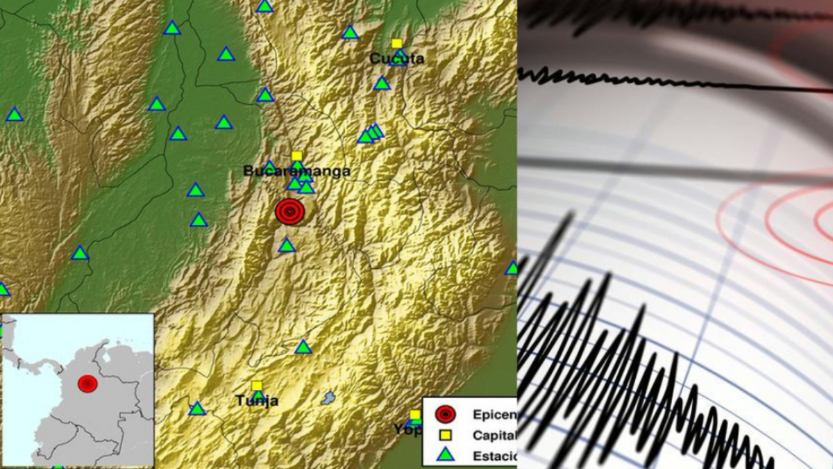
Just days later, on January 5, 2026, at 05:35 UTC, a magnitude 4.9 earthquake struck 3 kilometers east-northeast of Aratoca, Santander, at a depth of 170 kilometers. Classified as low severity, this intermediate-depth quake was less likely to cause surface damage given its profundity, though it was detectable in surrounding areas. Aratoca, a rural municipality in the Andean region, lies in a zone prone to tectonic activity from the subduction of the Nazca Plate beneath the South American Plate.
Details of the Events
The December 30 tremor, while not assigned a specific magnitude in initial reports, was characterized as "strong" and widely felt, aligning with medium-intensity events that often lead to temporary disruptions such as evacuations or pauses in daily activities. Such tremors are frequently reported in Colombia, where the SGC records thousands of seismic events annually, ranging from minor rumbles to more powerful quakes.
The January 5 event, detailed in reports from El Tiempo, pinpointed the epicenter near Aratoca. At 170 km deep, the quake exemplifies intermediate-depth seismicity common in the northern Andes. Shallow quakes (less than 70 km) pose greater risks, but deeper ones like this can still be felt over broad areas. No major impacts were noted, consistent with its low severity rating.
Both events were captured through real-time monitoring systems, including the SGC's network of over 100 stations nationwide. Public response included activation of early warning apps and social media reports of shaking, but authorities did not issue tsunami alerts, as neither event originated from coastal subduction zones.
Background on Colombia's Seismic Activity
Colombia sits atop the Pacific Ring of Fire, a 40,000-kilometer horseshoe-shaped belt where 90% of the world's earthquakes occur. The interaction between the Nazca, Caribbean, and South American plates generates frequent tremors. The country averages about 1,000 perceptible earthquakes per year, with magnitudes above 4.0 happening several times monthly.
Historically, Colombia has endured devastating quakes, such as the 1999 Armenia earthquake (magnitude 6.2), which killed over 1,100 people in the coffee-growing region of Quindío. More recently, a 6.4-magnitude event struck near Paratebueno in 2021, causing structural damage but limited fatalities due to improved building codes. The SGC emphasizes preparedness, with mandatory seismic-resistant construction in high-risk zones and nationwide drills.
The Andean cordilleras amplify shaking due to mountainous terrain, while urban centers like Bogotá, Medellín, and Cali experience amplified effects from soft soils. Government initiatives, including the National Risk Management Unit (UNGRD), promote apps like the SGC's "ÍnformaSismo" for real-time alerts.
Current Status and Monitoring
As of January 5, 2026, no aftershocks of notable magnitude have been reported from either event, though seismic swarms can persist. The SGC continues 24/7 monitoring, urging residents to identify safe spots indoors and prepare emergency kits. International bodies like the U.S. Geological Survey (USGS) corroborate data, listing the Aratoca quake in global catalogs.
These incidents serve as reminders of Colombia's vulnerability, where over 80% of the population lives in seismic zones. Enhanced infrastructure and public education have reduced fatalities in recent decades, but experts stress ongoing vigilance amid climate-influenced fault stresses.
In a nation where earthquakes are a geological constant, these events highlight the effectiveness of monitoring systems in minimizing harm. Updates from the SGC and local authorities remain the primary sources for developments.
(Word count: 612)


