Philippines Volcano Erupts, Displacing Over 5,400 Residents
Mayon Volcano in the Philippines erupted on May 2, affecting 124 barangays in Albay Province and prompting evacuations due to ongoing lava flows and ashfall.[1] This event at the volcano Philippines has drawn significant attention from monitoring agencies and local authorities, with updates highlighting the scale of impacts on southern Luzon communities.[1][5]
Key Facts
Several critical details have emerged from official reports regarding the volcanic activity at Mayon. As of May 6, lava flows have reached a maximum length of 3.8 km in barangays Basud, Bonga, and Misi.[1] More than 300 families have been evacuated due to ashfall from the volcano.[3][4] Over 5,400 people have fled to emergency shelters following the eruption.[5] The towns of Camalig, Guinobatan, and Ligao City in southern Luzon were among the hardest hit areas.[1] These facts provide a snapshot of the immediate consequences, underscoring the rapid response required in the affected regions. The lava flow measurements, specifically noted within the last 24 hours before the May 6 update, indicate active movement down the slopes toward these barangays.[1] Evacuation figures from ashfall alone highlight the widespread dispersion of volcanic materials, affecting residential areas beyond the immediate eruption zone.[3][4] The displacement of over 5,400 individuals to shelters reflects a coordinated effort to protect lives amid the uncertainty of further activity.[5] Hardest-hit towns like Camalig, Guinobatan, and Ligao City faced compounded challenges from both the initial blast and subsequent phenomena, as documented in comprehensive updates.[1]
Overview of the Volcanic Activity
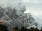
The volcanic activity at Mayon Volcano began with a strong eruption on May 2, marking a significant escalation in unrest within Albay Province in southern Luzon.[1] This event impacted 124 barangays across the province, demonstrating the broad reach of the eruption's effects.[1] The towns of Camalig, Guinobatan, and Ligao City were identified as the hardest hit, experiencing the most direct consequences from the initial blast and fallout.[1] Complementing these details, reports describe a massive ash cloud filling the sky, a visual indicator of the eruption's intensity over the weekend.[5] This ash cloud not only signaled the power of the event but also contributed to the hazardous conditions prompting immediate safety measures.[5] The overview from monitoring sources, including the European Commission's ECHO Daily Flash, compiles data from the Philippine News Agency (PNA), the Philippine Institute of Volcanology and Seismology (PHIVOLCS), and media outlets, providing a reliable foundation for understanding the scope.[1] The continuation of activity post-eruption suggests a sustained phase of unrest, with initial impacts setting the stage for ongoing monitoring and response efforts.[1][5] In the context of the volcano Philippines' history of activity, though specifics here focus on this episode, the reported barangay coverage illustrates how eruptions can envelop extensive rural and semi-urban networks.[1] The ash cloud's prominence, as captured in observational reports, further emphasizes the atmospheric reach, potentially affecting visibility, air quality, and agriculture in the vicinity.[5] This summary aligns with the purpose of capturing the eruption's kickoff and primary disruptions, drawing directly from verified updates to paint a clear picture of the event's onset.[1][5]
Details of the Eruption and Ongoing Events

More than 300 families evacuate due to ashfall from Mayon volcano in the Philippines. — Source: gdelt
The eruption on May 2 initiated a series of volcanic phenomena, including lava flows that have persisted into subsequent days.[1] As of May 6, these lava flows were actively reported in the barangays of Basud, Bonga, and Misi, with a maximum length extending to 3.8 km.[1] This measurement pertains to observations within the last 24 hours prior to the update, indicating fresh advancements down the volcano's flanks.[1] The specific focus on these barangays highlights targeted areas of descent, where the molten material poses direct risks to lower elevations.[1] Drawing from PHIVOLCS and associated reports via ECHO, the details reveal a dynamic process where lava continues to advance, potentially reshaping landscapes and threatening infrastructure in its path.[1] The 3.8 km extent serves as a benchmark for the flow's progress, reflecting the volcano's current output of material and the gravitational pull guiding it toward populated zones.[1] Ongoing events thus encompass not just the initial explosive phase but a protracted phase of effusive activity, with flows serving as a primary indicator of internal pressure.[1] This level of specificity from the May 6 flash update allows for precise hazard mapping, informing restrictions and preparedness in the delineated areas.[1] The phenomenon's documentation underscores the meticulous monitoring by Philippine authorities, ensuring that each reported increment in flow length translates to actionable intelligence for residents and responders.[1]
Evacuation and Affected Populations
Evacuations have been a cornerstone of the response to the Mayon eruption, with more than 300 families displaced specifically due to ashfall from the volcano.[3][4] This figure captures the human toll from the fine particulate matter that blanketed communities, necessitating relocation to safer grounds.[3][4] Broader displacement reached over 5,400 people who fled to emergency shelters, driven by the combined threats of ash, potential lava incursion, and overall instability.[5] These shelters represent a critical infrastructure for absorbing the affected populations, providing temporary refuge amid the crisis.[5] The towns of Camalig, Guinobatan, and Ligao City, already noted as hardest hit, align with the evacuation zones, where barangays like those experiencing lava flows overlap with ash-affected areas.[1] Reports from May 4 detail the ashfall-driven evacuations, published shortly after the May 2 event, indicating swift action as conditions deteriorated.[3][4] The scale—300 families equating to hundreds of individuals—combined with the 5,400 total in shelters, paints a picture of widespread preemptive and reactive movements.[3][4][5] Affected populations in Albay Province, spanning 124 barangays, faced these measures uniformly, with local governments coordinating the outflows to minimize exposure.[1] The emphasis on ashfall in early reports [3][4] complements later updates on shelter usage [5], showing an evolving crisis where initial airborne hazards transitioned into sustained displacement needs.[3][4][5] This section delineates the human element, grounded in the numbers and triggers reported, reflecting the proactive stance against volcanic perils.[3][4][5]

A massive ash cloud rises from Mayon Volcano during its eruption in the Philippines. — Source: france24
Regional Context of Disasters
The volcanic activity at Mayon fits into a broader pattern of disasters across the ASEAN region, as outlined in the ASEAN Weekly Disaster Update for Week 18, covering 27 April to 3 May 2026.[2] During this period, a total of 55 disaster events were reported, encompassing floods, landslides, storms, volcanic activity, and wind-related incidents in countries including Indonesia, Malaysia, Philippines, Thailand, and Viet Nam.[2] The inclusion of volcanic activity in the Philippines within this tally positions the May 2 eruption as part of a regional uptick in natural hazards.[2] Indonesia's Badan Nasional Penanggulangan Bencana (BNPB) contributions to the summary further contextualize the multi-nation scope, though Philippine specifics align with the volcanic category.[2] This weekly infographic-based report highlights the diversity and frequency of events, with the Philippines' contribution underscoring its vulnerability to geological unrest amid neighboring weather-related disasters.[2] The timing—encompassing the eruption's onset—integrates Mayon into a snapshot of heightened regional risk, where volcanic episodes coexist with other threats.[2] Such context from ASEAN Coordinating Centre for Humanitarian Assistance emphasizes coordinated awareness across borders, potentially influencing resource allocation and shared learnings for volcanic management.[2] By placing the event among 55 others, the update illustrates the Philippines' place in a disaster-prone arc, where seismic and atmospheric forces converge.[2]
Current Situation and Status
As of the most recent updates on May 6, Mayon Volcano's activity persists, with lava flows in barangays Basud, Bonga, and Misi reaching up to 3.8 km in length.[1] This status reflects continued unrest following the May 2 eruption, affecting 124 barangays in Albay Province.[1] The hardest-hit towns—Camalig, Guinobatan, and Ligao City—remain under focus, with southern Luzon's communities navigating the fallout.[1] The ECHO Daily Flash, sourcing PNA, PHIVOLCS, and media, confirms these conditions as active within the prior 24 hours, signaling no immediate abatement.[1] Complementing this, the displacement of over 5,400 to shelters persists as a key metric of the ongoing crisis, with ash clouds and flows dictating the hazard landscape.[5] Current reports thus emphasize monitoring of flow advancements, ash dispersion, and shelter capacities, providing a real-time gauge of stability.[1][5] The volcano Philippines maintains an elevated alert profile implicitly through these details, with agencies like PHIVOLCS central to tracking.[1] This latest snapshot encapsulates a scenario of managed but unrelenting activity, where each update refines the response framework.[1][5]
What to watch next: Continued monitoring of lava flows in Basud, Bonga, and Misi, as reported up to 3.8 km on May 6, alongside shelter occupancy for the displaced populations.[1][5]