Heavy Snow and Drifting Snow Force Road Closures in Groningen as Dutch Big Freeze Persists
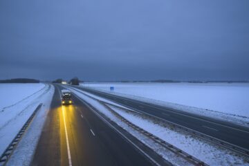
Groningen, Netherlands – Heavy snowfall and drifting snow have triggered road closures across Groningen province in the northern Netherlands, disrupting travel amid a prolonged cold snap gripping the country. The severe weather event, which began on Friday, January 9, 2026, at approximately 3:48 p.m. GMT, coincides with forecasts of sub-zero temperatures persisting through the weekend.
The closures stem from accumulating snow and strong winds causing drifts that have made several roads impassable, according to provincial authorities. While specific routes affected were not detailed in initial reports, the situation has prompted warnings for motorists to avoid non-essential travel in the region. This medium-severity event underscores the challenges posed by the ongoing "big freeze," with a very cold weekend anticipated nationwide.
Snowfall has been particularly disruptive in the north, where Groningen is located, exacerbating conditions from an Arctic air mass that has dominated Dutch weather since early January. The Dutch Meteorological Institute (KNMI) has issued code yellow warnings for snow and ice across multiple provinces, highlighting the risks of slippery roads and reduced visibility.
Widespread Cold Snap Continues
The broader weather pattern is marked by unrelenting sub-zero temperatures, as reported by DutchNews.nl on Saturday, January 10, 2026. While snow is expected to continue falling in the south and south-east of the Netherlands on Saturday, other areas—including the north like Groningen—face dry but bitterly cold conditions with daytime highs remaining below freezing.
"Sub-zero temperatures all day as Dutch big freeze continues," the DutchNews.nl article states, noting that the cold weather is set to linger. Winds from the east, carrying frigid air from Siberia, have been the primary driver, a common setup for harsh winter spells in the Netherlands. Overnight lows have dipped to -10°C (-14°F) in some areas, with ice formation on untreated surfaces adding to hazards.
In Groningen, the combination of fresh snow and drifts has led to proactive measures by local authorities. Emergency services have been placed on standby, and de-icing operations are underway where feasible. Travelers are advised to check real-time updates from Rijkswaterstaat, the national road authority, which manages major highways potentially impacted.
Background on Dutch Winter Weather Disruptions
The Netherlands, with its flat terrain and dense road network, is highly vulnerable to snow events despite its generally mild maritime climate influenced by the North Sea. Winters are typically wet and overcast rather than snowy, but intrusions of continental polar air can lead to significant disruptions. Historical precedents include the 2010 "Snowmageddon," when heavy snow paralyzed airports and motorways, and the 1991 cold wave that brought record lows.
Groningen province, bordering Germany in the northeast, often bears the brunt of northerly or easterly winds funneling snow across the border. The region's rural roads and polders—low-lying reclaimed land—are prone to drifting, amplifying closure risks. Climate data from KNMI indicates that such events, while infrequent, occur roughly once every few years during La Niña-influenced winters, which enhance cold outbreaks in Europe.
This week's freeze follows a pattern observed across northern Europe, where similar weather has caused disruptions in Germany, Poland, and Scandinavia. The European Centre for Medium-Range Weather Forecasts (ECMWF) models predicted the Arctic plunge several days in advance, allowing preparations but not averting all impacts.
Impacts and Safety Measures
Beyond road closures, the weather has ripple effects on daily life. Schools in affected areas may delay openings, and public transport schedules face delays. Energy demands are rising due to heating needs, though the grid has held steady so far. Health authorities warn of hypothermia risks for the vulnerable, including the elderly and homeless populations.
Rijkswaterstaat and provincial teams have deployed gritters and plows, but drifting snow poses ongoing challenges. "Expect a very cold weekend ahead," aligns with forecasts showing little respite until mid-week, when milder Atlantic air may return.
As of Saturday morning, no major accidents were reported from the Groningen closures, but officials urge caution. The KNMI advises layered clothing, checking vehicles for winter kits, and using public transport where possible.
Outlook: Prolonged Chill with Gradual Thaw
The big freeze is expected to peak over the weekend, with Saturday seeing continued snow in southern regions and bone-chilling cold elsewhere. Sunday may bring light flurries to the north, maintaining slippery conditions in Groningen. Relief appears by Tuesday, January 13, as high pressure builds and temperatures climb above freezing.
This event serves as a reminder of the Netherlands' preparedness for winter extremes, honed by past incidents. While not catastrophic, it highlights the interplay between climate variability and infrastructure resilience in a low-lying nation.
(Word count: 612)