Cyclone Koji Downgraded to Storm After Landfall in Queensland, Triggering Widespread Flood Warnings
Brisbane, Australia – Tropical Cyclone Koji weakened to a storm after crossing Australia's northeast coast on January 11, 2026, raising concerns over heavy rainfall and potential flooding across Queensland. Authorities have issued flood warnings as the system continues to bring intense rains and gusty winds to the region.
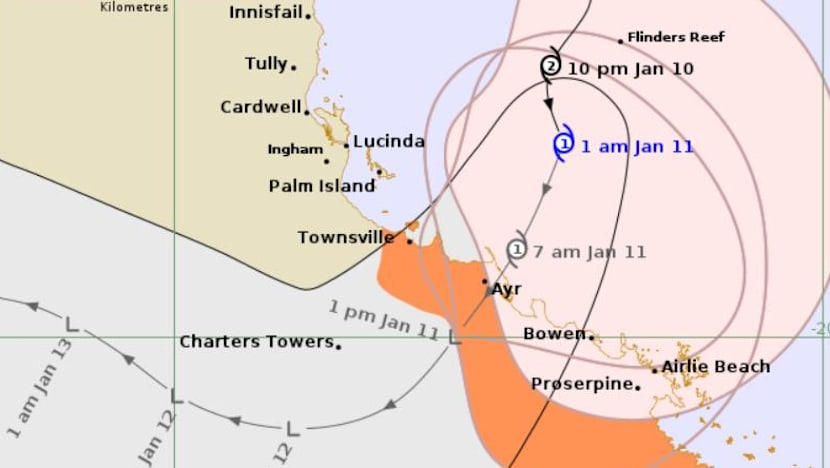
The cyclone made landfall near the Queensland coast early on Sunday, prompting immediate downgrades from the Bureau of Meteorology (BoM). Initially classified as a severe weather event of medium severity, Koji transitioned into a tropical low, but its remnants are expected to deliver significant precipitation, exacerbating risks in already saturated areas. Evacuation orders and emergency alerts were activated prior to landfall, with residents urged to avoid flood-prone zones.
Immediate Impacts and Response Measures
As Koji crossed the coast, it unleashed heavy rains and strong winds, consistent with patterns observed in similar systems. The BoM reported wind gusts exceeding safe thresholds during the cyclone's peak intensity, though no widespread structural damage has been confirmed in initial assessments. Flood watches are now in effect for multiple river catchments in northeast Queensland, including areas around Cairns and Townsville, where rainfall totals could surpass 200 millimeters in the coming days.
Emergency services, including the Queensland State Emergency Service (SES), have mobilized resources for potential rescues and sandbagging operations. "Communities should remain vigilant as the risk of flash flooding persists," a BoM spokesperson noted in updates following the downgrade. Power outages were reported in isolated pockets, reminiscent of disruptions from prior events, but infrastructure held up better than anticipated due to preemptive preparations.
This event underscores Queensland's vulnerability during the southern hemisphere's wet season, which typically runs from November to April. The state's tropical climate fosters the rapid development of cyclones in the Coral Sea, drawing moisture from warm ocean waters.
Background: A Pattern of Cyclonic Activity in Queensland
Koji's arrival follows a string of severe weather incidents in the region. Notably, in March of the previous year, Tropical Cyclone Alfred – also downgraded upon landfall – battered Queensland with damaging winds and torrential rains. That event cut power to hundreds of thousands of residents, caused widespread flooding, and led to significant economic losses estimated in the billions of Australian dollars. Recovery efforts from Alfred were still ongoing when Koji formed, highlighting the cumulative strain on local resources.
Queensland has a long history of cyclonic impacts. The BoM tracks systems using advanced satellite and radar technology, categorizing them from 1 to 5 based on wind speeds. Category 1 cyclones, like the downgraded Koji, produce gale-force winds (up to 125 km/h) but can still generate life-threatening floods. Historical precedents include Cyclone Yasi in 2011, which devastated far north Queensland with winds over 280 km/h, and more recent storms like Debbie in 2017, which caused over 10 fatalities and A$5.6 billion in damages.
Climate data from the Australian government indicates that while cyclone frequency has remained stable, their intensity and rainfall output may be influenced by warming sea surface temperatures. The 2025-2026 wet season has already seen above-average rainfall across northern Australia, priming soils for rapid runoff.
Regional Context and Broader Implications
Northeast Queensland, encompassing the Wet Tropics and Great Barrier Reef regions, relies heavily on tourism, agriculture (particularly sugar cane and bananas), and mining. Severe weather disrupts these sectors profoundly; for instance, Alfred's floods last year led to crop failures and reef stress from sediment runoff. With Koji's moisture lingering, agricultural losses could mount if rivers like the Herbert and Tully burst their banks.
Federal and state governments have ramped up resilience measures in recent years, including the A$1.5 billion Flood Resilience Program and upgraded early warning systems. The National Emergency Management Agency (NEMA) coordinates multi-agency responses, emphasizing community education on cyclone preparedness.
Internationally, Australia's cyclone season aligns with global tropical activity peaks. Comparable systems, such as those affecting the U.S. Gulf Coast or the Philippines, share traits like post-landfall weakening and flooding dominance.
Outlook: Monitoring for Secondary Hazards
As of January 11, 2026, Koji's remnants are tracking southwest inland, potentially interacting with monsoon troughs to amplify rainfall further south. The BoM forecasts a 70-90% chance of heavy falls through mid-week, with isolated severe thunderstorms possible. Residents are advised to monitor official alerts via the BoM app and local radio.
While the immediate cyclone threat has passed, the focus shifts to flood mitigation. No fatalities have been reported from Koji, a testament to robust forecasting and evacuations. However, the back-to-back nature of these events – Koji just months after Alfred – serves as a stark reminder of Australia's exposure to intensifying weather patterns.
Queensland officials project a gradual return to normalcy, barring unforeseen escalations. Updates will continue as new data emerges, with recovery support pledged for affected communities.
(Word count: 712)


