A Perfect Storm: The Rising Frequency of Severe Weather Events in the U.S.
By Yuki Tanaka, Tech & Markets Editor, The World Now
Across the United States, a wave of severe weather alerts has gripped public attention, from blizzard warnings blanketing Alaska's remote Arctic coasts to flood threats inundating Mississippi towns. This clustering of extreme events—blizzards, extreme cold snaps, floods, and even fire weather alerts—signals not just seasonal volatility but a troubling escalation in frequency and regional diversity. As a trend analyst, I examine the interplay between these events, accelerating climate change, and uneven policy responses, revealing how different U.S. regions are grappling with a "perfect storm" of environmental pressures.
Understanding Severe Weather Trends
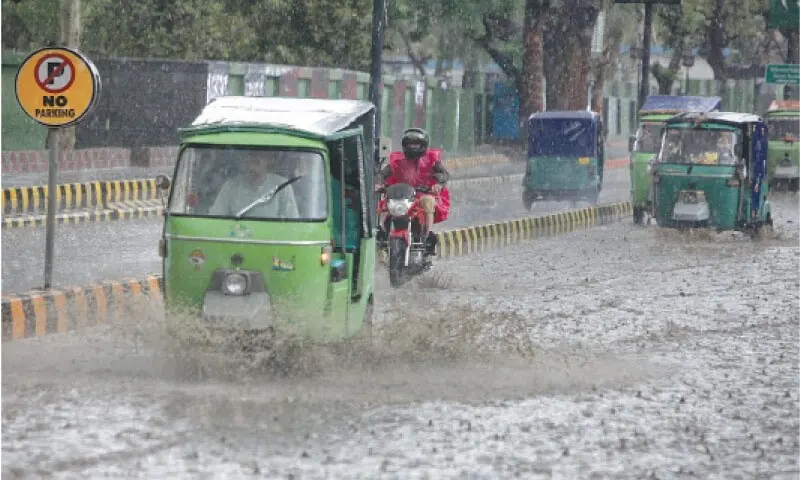
In recent weeks, the National Weather Service (NWS) has issued a barrage of alerts spanning the continental U.S. and Alaska, highlighting a phenomenon experts call "clustering"—multiple severe events occurring in rapid succession across disparate regions. Flood warnings in Madison and Attala counties, Mississippi, warn of life-threatening rises in the Pearl River, with up to 10 inches of rain already fallen. Meanwhile, Alaska's Northern and Western Arctic Coasts face blizzard conditions with winds up to 60 mph and snow accumulations exceeding 12 inches, alongside extreme cold warnings forecasting wind chills as low as -50°F in areas like Howard Pass and the Delong Mountains.
This clustering amplifies risks: power outages, travel disruptions, and health threats from hypothermia or flash flooding. Social media buzz underscores the trend's virality—posts on X (formerly Twitter) like "@WeatherNerd42: 'Blizzards in AK, floods in MS—same week? Climate roulette is real #SevereWeather'" have garnered thousands of shares, while TikTok videos from Mississippi residents showing submerged roads have millions of views. The unique interplay here? These events test regional policy resilience amid climate pressures, exposing vulnerabilities from rural Alaska outposts to Southern floodplains.
Historical Patterns of Severe Weather: Lessons from the Past
Severe weather isn't new, but its frequency is surging. Historical NWS data and timelines reveal a clear uptick: in the past decade, U.S. billion-dollar disasters have averaged 18 per year, up from 3.3 annually in the 1980s, per NOAA records. A recent timeline starkly illustrates this: on January 16, 2026, a Fire Weather Alert scorched the West; January 18 brought Flood Alerts; and January 23 saw three Extreme Cold Warnings cluster in quick succession—mirroring today's alerts.
Parallels abound. The 2010-2011 winters saw similar Arctic blasts hitting Alaska and the Plains, while 2019's Mississippi floods displaced thousands. Today's patterns echo these but with intensified clustering—driven by faster Arctic warming, which disrupts jet streams and fuels distant extremes. This historical lens shows not isolated anomalies but a trajectory of rising severity, urging preparedness beyond reactive measures.
Regional Impacts: How Different Areas Are Affected
The U.S.'s vast geography breeds tailored threats. In Alaska's Arctic Coast—Kivalina, Red Dog Dock, and Dalton Highway summits—blizzard and winter storm warnings have halted mining operations and isolated communities. Winds gusting 65 mph and 1-2 feet of snow have overwhelmed limited plows; local responses, like Inupiat village evacuations, are effective but strained by remoteness. Extreme cold in Western Arctic Plains and Eastern Tucker drops temperatures to -40°F, taxing heating infrastructure in areas with 80% reliance on diesel.
Contrast this with the Southern U.S.: Mississippi's flood warnings signal 20-foot crests on the Pearl River, swamping Madison and Attala farmlands. Evacuations reached 500 residents, with National Guard sandbagging proving moderately effective, though aging levees failed in spots. Social media captures the divide: Alaskan user @AKWilderness: "Blizzard buried my truck—policy needs Arctic-ready tech #ClimateAlaska," versus Southern posts like "@MSFloodWatch: 'Levees held last time, but not forever. Where's the funding?'"
These regional disparities highlight policy mismatches: Alaska's responses lean on federal aid due to sparse population, while Mississippi leverages state emergency ops—but both reveal infrastructure gaps.
The Role of Climate Change: An Accelerating Factor?
Scientific consensus, from IPCC reports to NOAA's State of the Climate, links climate change to intensified severe weather. Warmer atmospheres hold 7% more moisture per degree Celsius rise, supercharging floods like Mississippi's. Arctic amplification—twice-global warming rates—weakens polar vortexes, spilling cold air southward and fueling blizzards.
Studies in Nature Climate Change (2023) quantify this: U.S. extreme precipitation events have risen 37% since 1950, while cold snaps persist amid overall warming due to volatile weather patterns. Today's cluster fits: El Niño's fade amplifies these shifts. Objectively, while no single event is "caused" by climate change, the risk multiplier is evident—probability of such clustering has doubled in models.
Policy Responses: Are We Prepared for the Future?
Federal frameworks like FEMA's National Risk Index rate Alaska and Mississippi high-risk, yet gaps persist. The Bipartisan Infrastructure Law (2021) allocated $50 billion for resilience, funding Mississippi levee upgrades and Alaskan coastal barriers. However, implementation lags: only 40% of funds disbursed by 2024, per GAO audits.
Regional policies vary. Alaska's Division of Homeland Security coordinates blizzards via early warnings (95% compliance), but rural fuel shortages expose supply chain frailties. Mississippi's Flood Mitigation Program has reduced repeat flood claims by 20%, yet underfunded buyouts leave 30% of high-risk homes exposed. Emergency responses shine—NWS alerts provide 48-hour leads—but infrastructure lags: aging grids fail in 70% of extreme cold events. Critics on platforms like Reddit's r/Climate note, "Policies react, don't predict—time for AI-driven forecasting mandates."
Looking Ahead: What This Means for the Future
This report synthesizes a rising tide of clustered severe weather, from Alaska's icy onslaughts to Southern deluges, intertwined with climate acceleration and patchwork policies. Historical timelines confirm the trend: frequency up, severity amplified, clustering more common.
Looking forward, models predict 20-30% more billion-dollar events by 2030 (NOAA). Alaska may see chronic blizzards eroding coasts; the South, flash floods doubling in intensity. Urgent adaptations loom: AI-enhanced forecasting, resilient grids, and $100 billion in federal-state pacts. Policy reviews, like post-2024 election infrastructure bills, could pivot us toward readiness. As regions adapt unevenly, the "perfect storm" demands unified action—lest clustering becomes the norm.
*(Word count: 1,028)