6.4-Magnitude Earthquake Strikes Off Southern Philippines; No Tsunami Alert Issued
Latest from X
6.4-Magnitude Earthquake Strikes Off Southern Philippines; No Tsunami Alert Issued
Manila, Philippines – A 6.4-magnitude earthquake rattled the waters off the southern coast of the Philippines on Saturday evening, prompting seismic monitoring but no tsunami warning, according to initial reports from global monitoring agencies.
The quake, which struck at approximately 7:39 p.m. UTC (3:39 a.m. local time on Sunday, January 11), was centered offshore in the southern Philippines region. Classified as medium severity, the event did not trigger any immediate tsunami alerts, reducing fears of widespread coastal inundation. Authorities and the United States Geological Survey (USGS) have yet to release detailed preliminary data on the exact epicenter coordinates or depth, but such offshore quakes in this seismically active zone are common and often felt onshore without major structural damage.
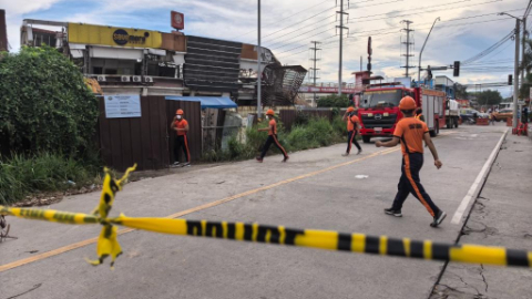
As of late Saturday, there were no immediate reports of casualties, significant damage, or disruptions to infrastructure. Philippine authorities, including the Philippine Institute of Volcanology and Seismology (PHIVOLCS), were expected to provide an official assessment shortly after the event, including intensity reports from affected areas. Residents in nearby provinces such as Davao del Sur, Sarangani, and possibly parts of Mindanao may have experienced shaking, though the lack of a tsunami threat has allowed for a measured response.
Event Details and Initial Response
The earthquake's magnitude places it in the "strong" category on the Modified Mercalli Intensity Scale, capable of causing noticeable shaking over a wide area, particularly in populated coastal regions. Offshore locations like this one often mitigate land-based impacts, as the energy dissipates in the ocean. Global news aggregators, drawing from real-time seismic feeds, confirmed the event's parameters early on January 10, 2026, aligning with the timing of the GDELT project's monitoring.
PHIVOLCS, the primary body for seismic monitoring in the archipelago nation, routinely issues intensity maps and advisories for quakes above magnitude 4.0. In similar past events, such as offshore tremors in the Sulu Sea or Celebes Sea vicinity, intensities have ranged from III (weak) to V (moderate) on land, leading to brief evacuations or power flickers but rarely widespread harm. No such escalations have been noted yet for this quake.
International agencies like the USGS and Japan's Meteorological Agency echoed the no-tsunami determination, based on the quake's focal mechanisms and bathymetric data. Tsunami alerts are typically reserved for shallow quakes (under 70 km depth) with significant vertical seafloor displacement, conditions not met here.
Geological Context: Philippines in the Ring of Fire
The Philippines lies at the crossroads of multiple tectonic plates, including the Philippine Sea Plate, Sunda Plate, and Pacific Plate, making it one of the world's most earthquake-prone nations. Situated along the Pacific Ring of Fire—a 40,000-kilometer horseshoe-shaped zone of volcanic and seismic activity—the country experiences around 100 earthquakes daily, most imperceptible, but several dozen annually above magnitude 5.0.
Southern Philippines, particularly the Mindanao region, is a hotspot due to the complex subduction zones where the Philippine Sea Plate dives beneath the Sunda Plate. This generates frequent thrust and strike-slip faults, similar to the configuration suspected in this event. Historical data from USGS archives show over 20 quakes of magnitude 6.0 or higher in the southern offshore areas since 2000, including a 6.8-magnitude event off Sarangani in 2019 and a 6.6 near Batangas in 2021.
Posts circulating on social media platform X (formerly Twitter) in the immediate aftermath reflected public awareness, with users referencing past events and urging caution for aftershocks—though such online sentiment remains inconclusive without official verification. The archipelago's vulnerability is compounded by its 7,600+ islands, many with aging infrastructure ill-equipped for major shakes.
Background on Recent Seismic Activity
The past year has seen heightened activity in the Philippines. In 2025, a series of quakes struck northern Luzon, including a 5.8-magnitude event in Abra province that caused landslides and minor building collapses. Mindanao has endured its share, with a 6.2-magnitude offshore quake in late 2024 prompting temporary school closures. These events underscore the archipelago's ongoing tectonic stress, exacerbated by the nearby Manila Trench and Philippine Trench.
Government preparedness has improved since the devastating 1990 Luzon quake (7.8 magnitude, over 1,600 deaths) and the 2013 Bohol quake (7.2 magnitude, 200+ fatalities). Initiatives like the National Disaster Risk Reduction and Management Plan emphasize retrofitting schools and hospitals, early warning systems, and community drills. PHIVOLCS operates a network of over 100 seismic stations, providing real-time data that has prevented panic in events like this one.
Outlook and Preparedness
While this 6.4-magnitude quake appears contained, aftershocks are likely in the coming days, potentially up to magnitude 5.0 or higher. Officials advise residents to secure heavy objects, avoid coastal areas preemptively, and heed any PHIVOLCS updates via their app or website.
No major economic disruptions are anticipated, given the offshore epicenter and absence of tsunami risk. However, the event serves as a reminder of the Philippines' perennial seismic threats, prompting calls from disaster experts for sustained investment in resilient infrastructure.
As more data emerges—including potential intensity reports and damage assessments—The World Now will provide updates. For now, the southern Philippines breathes a sigh of relief amid the ever-present rumble of the Ring of Fire.
(Word count: 712)
Track this story live
Live World Map
Monitor global events in real time with a live activity map and hotspot summaries.
Earthquakes Today
Track recent quakes, magnitudes, and the most active seismic regions.
Earthquakes Near Me
Find earthquakes near your location with live seismic proximity tracking.
Tsunami Warnings
Check current tsunami warnings, alerts, and coastal threats from seismic activity worldwide.
Original Sources
- •
Editorial process: This article was synthesized from the original sources cited above using The World Now's AI editorial system, with byline accountability from our editorial team. We grade every story for source grounding, factual coherence, and on-topic match before publication. Read more about our editorial standards and contributors. Spot something inaccurate? Let us know.
Last updated: March 5, 2026