Cyprus Faces Intense Cold Snap with Snow, Rain, and Thunderstorms as Low-Pressure System Intensifies
Nicosia, Cyprus – A powerful low-pressure system is sweeping across the eastern Mediterranean, ushering in a severe cold snap to Cyprus that promises plummeting temperatures, widespread rainfall, thunderstorms, sleet, and potential snow by early next week. The island, transitioning from a brief period of high-pressure stability, is bracing for rapidly deteriorating weather conditions starting immediately.
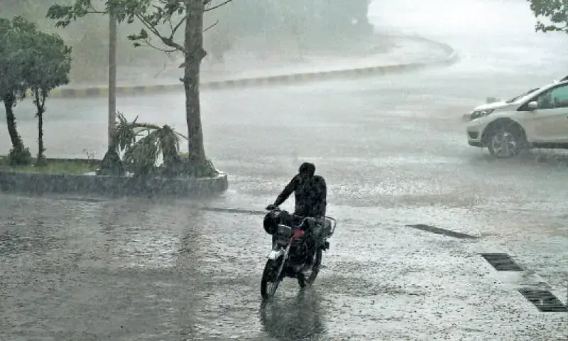
The meteorological shift began gaining momentum around January 7, 2026, with the low-pressure system expected to fully grip Cyprus by the weekend. According to reports from local weather monitoring, the event marks a medium-severity stormy weather episode characterized by heavy rain, thunderstorms, and strong winds following the dissipation of a preceding high-pressure system. Conditions escalated notably by January 11, as partial cloud cover and isolated showers observed earlier in the day gave way to heavy cloud dominance, particularly affecting western and southern districts.
The incyprus.philenews.com report details how a cold air mass is set to envelop the island from the following day after publication on January 11. "Today begins with partial cloud cover and isolated showers, but conditions will rapidly deteriorate," the article states, highlighting widespread local rain and potential thunderstorms in vulnerable areas. Sleet is anticipated in higher elevations, with snow possible in the Troodos Mountains, a range known for occasional winter flurries despite Cyprus's predominantly mild Mediterranean climate.
Cyprus's Department of Meteorology has issued warnings for the public to prepare for gusty winds reaching up to 60-70 km/h in exposed areas, alongside risks of localized flooding in low-lying regions. Temperatures are forecasted to drop significantly, with daytime highs struggling to exceed 10°C (50°F) in coastal areas and dipping below freezing overnight in mountainous zones. Coastal waters may see wave heights of 2-3 meters, prompting advisories for mariners and fishermen to exercise caution.
Weather Progression and Immediate Impacts
The low-pressure system's approach aligns with broader regional patterns observed in the eastern Mediterranean during mid-winter. Initially detected on January 7 at 06:23 GMT, the system has intensified, bringing a stark contrast to the high-pressure ridge that dominated earlier in the week, offering clear skies and milder conditions. By January 11, the weather had already turned, with heavy clouds delivering precipitation across much of the island.
Western districts like Paphos and Limassol, along with southern areas including Larnaca, are expected to bear the brunt of the thunderstorms. These storms could produce hail and brief but intense downpours, raising concerns for minor infrastructure disruptions such as power outages or road closures due to water accumulation. In the Troodos Mountains, where elevations exceed 1,900 meters at Mount Olympus, snow accumulation could reach several centimeters, attracting warnings for drivers and hikers while potentially boosting the local ski season at facilities like Troodos Ski Resort.
No major incidents have been reported as of January 11, but emergency services are on heightened alert. The Cyprus Civil Defence has recommended residents secure outdoor items, avoid unnecessary travel during peak storm hours, and monitor official updates from the Meteorological Service.
Historical Context and Regional Patterns
Cyprus, an EU member state situated at the crossroads of Europe, Asia, and Africa, experiences a classic Mediterranean climate with hot, dry summers and mild, wet winters. However, cold snaps like this one are not unprecedented. Similar low-pressure systems originating from the Balkans or Anatolia periodically plunge the island into wintry conditions. For instance, in January 2023, a comparable event brought rare snowfall to the capital Nicosia suburbs and record lows, disrupting air traffic and daily life.
The current system draws parallels to these episodes, exacerbated by the cold air mass funneling southward. Climate data from the Cyprus Meteorological Service indicates that such events contribute to the island's annual rainfall, vital for agriculture and reservoirs amid ongoing drought concerns. Yet, they also heighten risks of flash floods in urban areas like Nicosia and Famagusta, where drainage systems are occasionally overwhelmed.
Globally, these weather patterns tie into larger atmospheric dynamics, including the polar vortex's occasional southward extensions and the North Atlantic Oscillation's influence on Mediterranean weather. Scientists note that while individual events are natural, their intensity may be influenced by broader climate variability.
Outlook and Preparations
Forecasts suggest the cold snap will peak over the weekend of January 17-18, 2026, before gradually easing as high-pressure builds again by mid-week. Accumulated rainfall could total 50-100 mm in affected areas, providing relief to parched farmlands but necessitating vigilance against soil erosion on slopes.
Authorities urge the public to stay informed via official channels, including the Cyprus Meteorological Service app and website. Schools and some public services may implement flexible hours if conditions worsen. Tourists, a mainstay of Cyprus's economy, are advised to adjust plans, particularly for outdoor activities in the Troodos or coastal regions.
As Cyprus navigates this wintry interlude, the event underscores the island's vulnerability to abrupt weather shifts, prompting ongoing investments in early warning systems and resilient infrastructure. Updates will follow as the system evolves.
(Word count: 712)